Understanding Distance Calculations in Geography
Interactive Video
•
Geography
•
9th - 10th Grade
•
Practice Problem
•
Hard

Thomas White
FREE Resource
Read more
8 questions
Show all answers
1.
MULTIPLE CHOICE QUESTION
30 sec • 1 pt
What is the main focus of the video tutorial?
Learning about the solar system
Understanding Earth's distance calculations
Calculating the distance to the Moon
Studying the Earth's core
2.
MULTIPLE CHOICE QUESTION
30 sec • 1 pt
What is the primary difference between longitude and latitude?
Longitude measures north-south, latitude measures east-west
Longitude measures east-west, latitude measures north-south
Both measure the same direction
Longitude is used for time zones, latitude is not
3.
MULTIPLE CHOICE QUESTION
30 sec • 1 pt
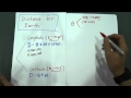
Which formula is used to calculate distance along longitudes?
Distance = angle / 60
Distance = angle * 60 * cos(alpha)
Distance = angle * 60
Distance = angle * sin(alpha)
4.
MULTIPLE CHOICE QUESTION
30 sec • 1 pt
In the longitude distance calculation example, what is the angle between 20E and 60W?
60 degrees
80 degrees
40 degrees
100 degrees
5.
MULTIPLE CHOICE QUESTION
30 sec • 1 pt
How do you calculate the distance along latitudes?
Distance = angle * sin(alpha)
Distance = angle / 60
Distance = angle * 60
Distance = angle * 60 * cos(alpha)
6.
MULTIPLE CHOICE QUESTION
30 sec • 1 pt
In the latitude example, what is the distance between 70N and 10N?
4,800 NAA M
3,600 NAA M
2,400 NAA M
5,000 NAA M
7.
MULTIPLE CHOICE QUESTION
30 sec • 1 pt
What is a key strategy for solving problems without diagrams?
Drawing your own diagrams
Using given information to deduce angles and distances
Memorizing all formulas
Ignoring the problem
Access all questions and much more by creating a free account
Create resources
Host any resource
Get auto-graded reports
Continue with Google

Continue with Email
Continue with Classlink
Continue with Clever
or continue with
Microsoft
%20(1).png)
Apple
Others
Already have an account?
