Understanding 6-Figure Grid References
Interactive Video
•
Geography
•
6th - 7th Grade
•
Practice Problem
•
Medium

Jennifer Brown
Used 2+ times
FREE Resource
10 questions
Show all answers
1.
MULTIPLE CHOICE QUESTION
30 sec • 1 pt
What is the primary purpose of grid references on a topographic map?
To determine the weather conditions
To measure the height of mountains
To find a location on a local scale
To calculate the distance between two points
2.
MULTIPLE CHOICE QUESTION
30 sec • 1 pt
What are the vertical lines on a topographic map called?
Northings
Longitudes
Eastings
Latitudes
3.
MULTIPLE CHOICE QUESTION
30 sec • 1 pt
In which order should you read the grid reference numbers?
Latitude first, then Longitude
Longitude first, then Latitude
Easting first, then Northing
Northing first, then Easting
4.
MULTIPLE CHOICE QUESTION
30 sec • 1 pt
What is the grid reference for point A on the simple map?
975280
975290
970290
970280
5.
MULTIPLE CHOICE QUESTION
30 sec • 1 pt
How is the grid reference for point B determined?
By reading the easting first
By using a compass
By estimating the distance from the center
By reading the northing first
6.
MULTIPLE CHOICE QUESTION
30 sec • 1 pt
What is the grid reference for point C on the simple map?
005255
005250
010250
010255
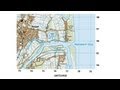
7.
MULTIPLE CHOICE QUESTION
30 sec • 1 pt
What is the easting value for the Surf Club on the Waimakariri River map?
775
770
780
765
Access all questions and much more by creating a free account
Create resources
Host any resource
Get auto-graded reports
Continue with Google

Continue with Email
Continue with Classlink
Continue with Clever
or continue with
Microsoft
%20(1).png)
Apple
Others
Already have an account?
Popular Resources on Wayground

7 questions
History of Valentine's Day
Interactive video
•
4th Grade
15 questions
Fractions on a Number Line
Quiz
•
3rd Grade
20 questions
Equivalent Fractions
Quiz
•
3rd Grade
25 questions
Multiplication Facts
Quiz
•
5th Grade
22 questions
fractions
Quiz
•
3rd Grade
15 questions
Valentine's Day Trivia
Quiz
•
3rd Grade
20 questions
Main Idea and Details
Quiz
•
5th Grade
20 questions
Context Clues
Quiz
•
6th Grade
Discover more resources for Geography
21 questions
Continents and Oceans
Quiz
•
6th Grade
10 questions
Seasons and Earth's Tilt
Quiz
•
7th Grade
12 questions
Russia, Central Asia, & the Caucasus
Quiz
•
6th Grade
20 questions
Mardi Gras History
Quiz
•
6th Grade - University
16 questions
Southern and Eastern Asia Government Basics
Quiz
•
7th Grade
21 questions
Plate Tectonics and Earth's Structure review quiz
Quiz
•
6th Grade
10 questions
38a, b, c: Voluntary trade in Africa
Quiz
•
7th Grade
10 questions
Understanding Landslides
Interactive video
•
5th - 6th Grade