Topographic Maps and Slopes Quiz
Interactive Video
•
Geography
•
6th - 8th Grade
•
Hard

Jennifer Brown
FREE Resource
3 questions
Show all answers
1.
MULTIPLE CHOICE QUESTION
30 sec • 1 pt
What is the purpose of the contour interval on a topographic map?
To show the distance between two points
To indicate the difference in elevation between contour lines
To measure the area of a region
To provide the exact elevation of a point
2.
MULTIPLE CHOICE QUESTION
30 sec • 1 pt
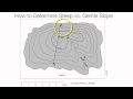
How can you identify a steep slope on a topographic map?
By finding the highest elevation point
By looking for widely spaced contour lines
By observing closely spaced contour lines
By checking the map's scale
3.
MULTIPLE CHOICE QUESTION
30 sec • 1 pt
What does a benchmark on a topographic map represent?
The average elevation of the area
The steepness of a slope
The distance between two points
An exact elevation at a specific point
Access all questions and much more by creating a free account
Create resources
Host any resource
Get auto-graded reports
Continue with Google

Continue with Email
Continue with Microsoft
or continue with

%20(1).png)
Apple
Others
Already have an account?
