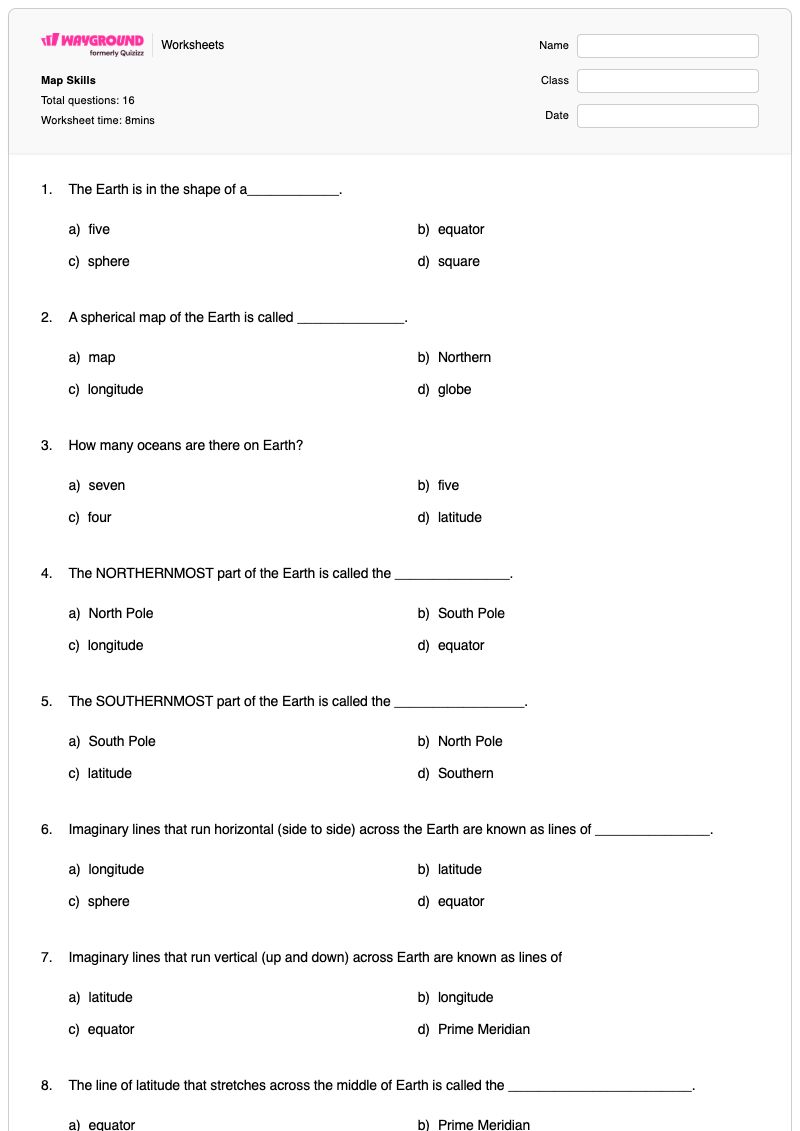
Map Skills is a free printable Grade 3 social studies worksheet that uses 16 multiple-choice questions to build foundational map and globe-reading vocabulary. Students identify Earth’s spherical shape, recognize a globe as a spherical map, recall the five oceans, and distinguish the North Pole, South Pole, equator, and Prime Meridian. They also classify horizontal lines as latitude and vertical lines as longitude.
The worksheet helps students connect geographic terms to locations and reference systems. Questions ask students to identify the four hemispheres, distinguish the Northern and Southern Hemispheres, recognize North America’s Western Hemisphere location, and differentiate absolute location based on latitude and longitude from relative location based on another place. It is suitable for Grade 3 review, independent practice, or a formative check, and includes a complete answer key for efficient checking.
Worksheet settings
Font size
S
M
L
XL
Worksheets
Map Skills
Total questions: 16
Name
Class
Date
1.
The Earth is in the shape of a____________.
a)
five
b)
equator
c)
sphere
d)
square
2.
A spherical map of the Earth is called ______________.
a)
map
b)
Northern
c)
longitude
d)
globe
3.
How many oceans are there on Earth?
a)
seven
b)
five
c)
four
d)
latitude
4.
The NORTHERNMOST part of the Earth is called the _______________.
a)
North Pole
b)
South Pole
c)
longitude
d)
equator
5.
The SOUTHERNMOST part of the Earth is called the _________________.
a)
South Pole
b)
North Pole
c)
latitude
d)
Southern
6.
Imaginary lines that run horizontal (side to side) across the Earth are known as lines of _______________.
a)
longitude
b)
latitude
c)
sphere
d)
equator
7.
Imaginary lines that run vertical (up and down) across Earth are known as lines of
a)
latitude
b)
longitude
c)
equator
d)
Prime Meridian
8.
The line of latitude that stretches across the middle of Earth is called the ________________________.
a)
equator
b)
Prime Meridian
c)
longitude
d)
latitude
9.
The line of longitude that stretches across the middle of Earth is called the______________.
a)
equator
b)
Prime Meridian
c)
longitude
d)
latitude
10.
The Earth has _________ hemispheres.
a)
6
b)
5
c)
7
d)
4
11.
The land ABOVE the equator is the _____________hemisphere.
a)
Southern
b)
Northern
c)
North Pole
d)
South Pole
12.
The land BELOW the equator is the ____________ hemisphere.
a)
Southern
b)
Northern
c)
North Pole
d)
South Pole
13.
Is North America in the Western of Eastern hemisphere?
a)
Eastern
b)
Western
14.
What kind of location is based on longitude and latitude?
a)
absolute
b)
relative
15.
What is the location of a place in relation to another location?
a)
absolute location
b)
relative location
16.
Why do we have 24 time zones?
a)
because it sounds cool
b)
because there are 24 continents
c)
because there are 24 hours in a day
Answer Key
Map Skills
Total questions: 16
1.
c)
sphere
2.
d)
globe
3.
b)
five
4.
a)
North Pole
5.
a)
South Pole
6.
b)
latitude
7.
b)
longitude
8.
a)
equator
9.
b)
Prime Meridian
10.
d)
4
11.
b)
Northern
12.
a)
Southern
13.
b)
Western
14.
a)
absolute
15.
b)
relative location
16.
c)
because there are 24 hours in a day
140 %
Browse by subjects
Browse by grades
Browse by format
FAQs
What does this Map Skills worksheet cover?
This Grade 3 worksheet uses multiple-choice questions to assess foundational map skills, including globes, oceans, poles, latitude, longitude, the equator, the Prime Meridian, hemispheres, and North America’s Western Hemisphere location. It also asks students to distinguish absolute location, based on latitude and longitude, from relative location, based on a place’s relationship to another location. Completing these items helps students connect geographic vocabulary with Earth’s reference system.
How can I use this worksheet to teach map skills?
Introduce the worksheet by reviewing a globe and tracing horizontal latitude lines, vertical longitude lines, the equator, and the Prime Meridian. Have students explain why the equator separates the Northern and Southern Hemispheres and then complete the multiple-choice items independently or with a partner. Afterward, discuss why a latitude-and-longitude description is an absolute location while a description based on another place is relative location.
What mistakes should I watch for when students complete this map skills worksheet?
Watch for students reversing latitude and longitude, especially when selecting the lines that run horizontally versus vertically. Students may also confuse the equator with the Prime Meridian, or interchange the Northern and Southern Hemispheres and the North and South Poles. The final location questions may reveal confusion between absolute location, which uses latitude and longitude, and relative location, which describes where a place is in relation to another place.
How do I assign and grade this Map Skills worksheet?
Wayground provides this worksheet as a printable PDF and as a digital quiz, and it includes a complete answer key for all multiple-choice questions. You can grade printable student submissions by scanning their work with the Wayground for Teachers app. The printable format also gives schools an option for practicing map skills with less screen use.
How can I differentiate this map skills worksheet for my students?
Use the worksheet’s Advanced Settings to adjust font spacing or increase the font size so the map vocabulary and multiple-choice options are easier to read. You can also enable a dyslexia-friendly font or translate the worksheet into another language when appropriate. These options can make terms such as latitude, longitude, equator, and hemisphere more accessible without changing the questions.
Where can I find more free worksheets like this on Wayground?
Wayground offers a comprehensive collection of free printable worksheets and practice problems across subjects, with downloadable PDFs and answer keys to support essential skills and concepts. Browse more resources at https://wayground.com/en-us/worksheets.

 Worksheets