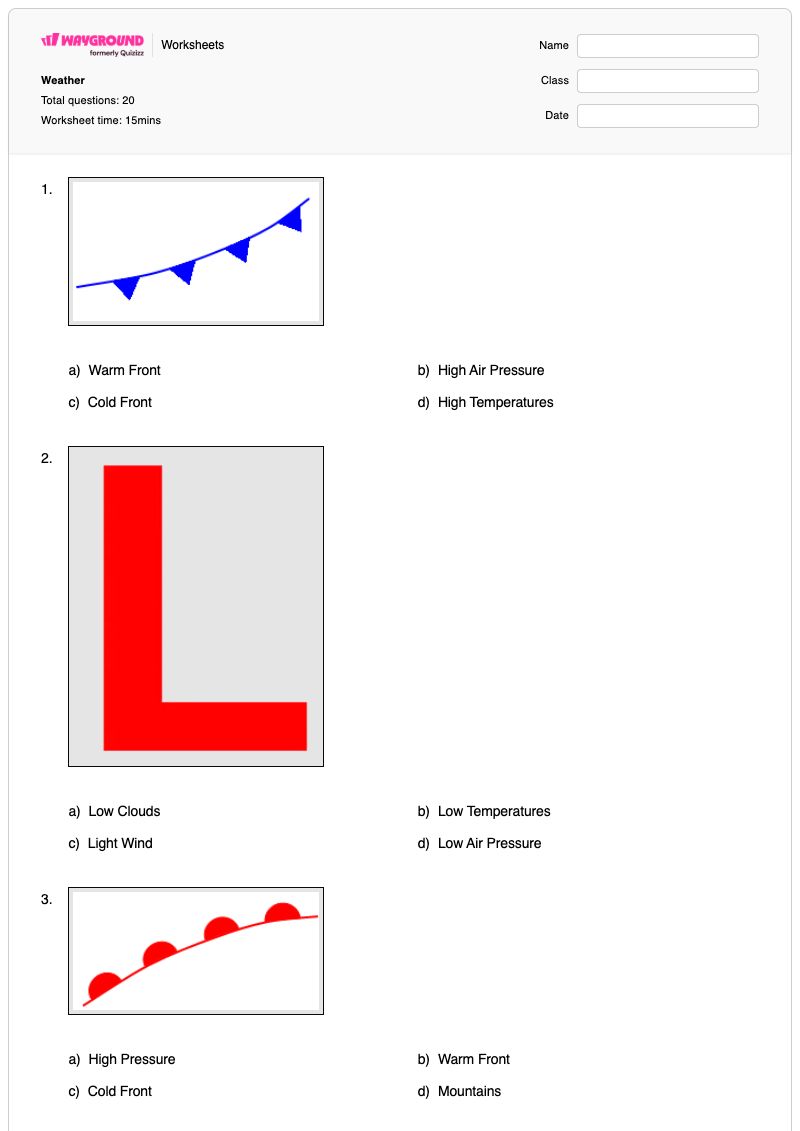

This Grade 8 science worksheet builds weather-map interpretation and atmospheric science skills through 20 questions: 19 multiple-choice items and 1 multiple-select item. Students connect air density to rising warm air, distinguish high- and low-pressure weather, identify cold-front movement and temperature changes, interpret the jet stream, and use pressure systems and fronts to predict weather in cities such as Seattle, Chicago, Dallas, and Los Angeles. The questions require students to apply weather patterns rather than recall isolated definitions.
Use this resource for independent practice, a review lesson, or a formative assessment after teaching air movement, pressure systems, fronts, and forecasting. Students must also select two causes of precipitation near a low-pressure system, giving you a quick check of whether they can recognize more than one correct explanation. This is a free printable worksheet with a complete answer key for efficient checking and feedback.
Worksheet settings
Font size
S
M
L
XL
Worksheets
Weather
Total questions: 20
Name
Class
Date
1.
a)
Warm Front
b)
High Air Pressure
c)
Cold Front
d)
High Temperatures
2.
a)
Low Clouds
b)
Low Temperatures
c)
Light Wind
d)
Low Air Pressure
3.
a)
High Pressure
b)
Warm Front
c)
Cold Front
d)
Mountains
4.
High Pressure is associated with this type of weather...
a)
Cloudy/Overcast Weather
b)
Cold Weather
c)
Warm Weather
d)
Fair Weather
5.
What causes warm air to rise?
a)
the fact that it's less dense than cold air
b)
The fact that it weighs more than cold air
c)
The fact that it has higher pressure than cold
d)
the fact that its more dense than cold air
6.
Hot air moves in __________________direction.
a)
Upward
b)
Downward
c)
Circular
d)
Sideways
7.
The cold front is moving
a)
east and southeast
b)
west and northwest
c)
north
d)
south
8.
A cold front is approaching Minneapolis. What will happen to the air temperature?
a)
stay the same
b)
increase
c)
decrease
9.
Choose the best forecast for Seattle on Saturday.
a)
rain
b)
sunny skies
c)
warmer temperatures
d)
snow
10.
Choose the best forecast for Chicago on Saturday.
a)
rain
b)
warmer temperatures
c)
snow
d)
sunny skies
11.
Choose the best forecast for Dallas on Saturday.
a)
thunderstorms
b)
snow
c)
warmer temperatures
d)
clear skies
12.
Choose the best forecast for Los Angeles on Saturday.
a)
cooler temperatures
b)
warmer temperatures
c)
low pressure
d)
snow
13.
a)
High Air Pressure
b)
High Temperatures
c)
Heavy Rain
d)
Hail
14.
Why do you see precipitation near the L? (select 2 answers)
a)
because that is low pressure and that is where air rises, forming clouds
b)
because that is where air is falling and it brings rain with it
c)
because southern Ohio is always rainy this time of year
d)
because the cold front is meeting the warm front which forces warm air to rise rapidly forming clouds
15.
The Jet Stream is a global pattern of atmospheric movement that influences patterns in local weather. Based on the information provided in the weather map, which city shown will most likely experience a drop in pressure over the next few days?
a)
Baltimore
b)
Portland
c)
Rapid City
16.
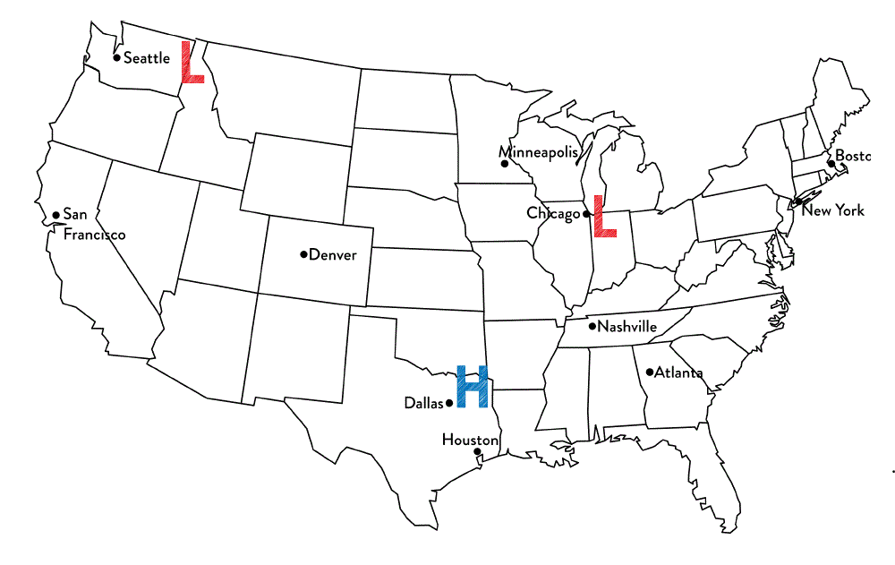
Near which two cities are the low pressure systems located?
a)
Seattle & San Francisco
b)
Chicago & Seattle
c)
Dallas & Houston
d)
Chicago & Nashville
17.
Near which city is the high pressure system located?
a)
Seattle
b)
Minneapolis
c)
Dallas
d)
Chicago
18.
Which two cities are most likely to experience clear, dry weather?
a)
Seattle & San Francisco
b)
Chicago & Minneapolis
c)
Chicago & Nashville
d)
Dallas & Houston
19.
Tim said that Chicago is most likely to experience rainy weather. Jennifer thinks that Dallas is most likely to experience rainy weather.
Which student is correct?
a)
Tim because Chicago is the closest to a low pressure system and they produce precipitation.
b)
Jennifer because high pressure systems produce precipitation
c)
Both students are correct because all systems produce precipitation
d)
Neither of the students are correct because the cities are not close enough to the system.
20.
Why does city "B" have clear skies?
a)
It is in North America
b)
There is not a front moving through city "B"
c)
Clouds do not form in the West
d)
It is located near a high pressure system
Answer Key
Weather
Total questions: 20
1.
c) Cold Front
2.
d) Low Air Pressure
3.
b) Warm Front
4.
d) Fair Weather
5.
a) the fact that it's less dense than cold air
6.
a) Upward
7.
a)
east and southeast
8.
c)
decrease
9.
a) rain
10.
d) sunny skies
11.
a) thunderstorms
12.
a) cooler temperatures
13.
a) High Air Pressure
14.
a)
because that is low pressure and that is where air rises, forming clouds
, d)
because the cold front is meeting the warm front which forces warm air to rise rapidly forming clouds
15.
a)
Baltimore
16.
b)
Chicago & Seattle
17.
c)
Dallas
18.
d)
Dallas & Houston
19.
a)
Tim because Chicago is the closest to a low pressure system and they produce precipitation.
20.
d)
It is located near a high pressure system
140 %
Browse by subjects
Browse by grades
Browse by format
FAQs
What does this Grade 8 weather worksheet cover?
This worksheet practices interpreting weather maps and applying relationships among air density, rising warm air, high and low pressure, cold fronts, the jet stream, and precipitation. Its 19 multiple-choice questions and 1 multiple-select question ask students to use those patterns to predict conditions and temperature changes in specific cities, including Seattle, Chicago, Dallas, and Los Angeles.
How can I use this worksheet to teach weather-map interpretation?
Introduce the worksheet by modeling how less-dense warm air rises, then connect rising air to pressure systems, clouds, and precipitation. Have students explain the direction of a cold front and its effect on Minneapolis before asking them to interpret the city forecasts and pressure-system questions. Use the multiple-select precipitation item as a discussion prompt about why low pressure and fronts can produce rising air and clouds.
What mistakes should I watch for when students complete this weather worksheet?
Watch for students reversing the effects of high and low pressure, choosing precipitation near a high-pressure system, or treating every answer choice in the multiple-select item as correct. Students may also confuse the direction of the cold front, predict a temperature increase when it approaches Minneapolis, or select a city based on its name rather than its position relative to a pressure system or front on the map.
How do I assign and grade this weather worksheet?
The worksheet is available as a printable PDF and as a digital quiz on Wayground, and it includes a complete answer key for all 20 items. For printable submissions, you can scan student work with the Wayground for Teachers app to help grade responses efficiently. The printable format can also support schools that are reducing screen time.
How can I differentiate this weather-map worksheet for my students?
Use the worksheet’s Advanced Settings to adjust font spacing and font size so the pressure-system, front, and city-forecast questions are easier to read. You can also enable a dyslexia-friendly font or translate the worksheet into another language when those file-level options support access to the weather vocabulary and map questions.
Where can I find more worksheets like this on Wayground?
Wayground offers a comprehensive collection of free printable worksheets and practice problems across subjects, with downloadable PDFs and answer keys to help students master essential skills and concepts. Browse more resources at https://wayground.com/en-us/worksheets.