

Wayground
World Geography Review - Printable Social studies Worksheets 8th Grade - Wayground

World Geography Review

Terri Brandt

Created by Terri Brandt

20 questions

8th Grade

Social studies

Updated Oct 2026

World Geography Review is a free printable Grade 8 geography worksheet that helps students build foundational world geography vocabulary. Across 20 questions—16 multiple-choice and 4 multiple-select—students identify the Prime Meridian and Equator, distinguish latitude from longitude, connect parallels and meridians to their measurements, and name the Eastern, Western, Northern, and Southern Hemispheres. The worksheet also checks understanding of key physical geography terms, including mountain range, continent, and Asia as the largest continent. Use this review worksheet to reinforce map and globe terminology after instruction or to check students’ readiness for more advanced coordinate-based geography work. The selected-response format gives students repeated practice distinguishing closely related terms and applying definitions to directional relationships. It is suitable for independent practice, a review station, homework, or a short formative assessment. The free printable worksheet includes a complete answer key for efficient checking and feedback.

Worksheet settings

Font size

S
M
L
XL
WaygroundWorksheets

World Geography Review

Total questions: 20

Name
Class
Date
1.
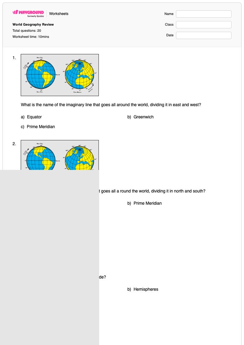
What is the name of the imaginary line that goes all around the world, dividing it in east and west?

What is the name of the imaginary line that goes all around the world, dividing it in east and west?

a)

Equator

b)

Greenwich

c)

Prime Meridian

2.
What is the name of the imaginary line that goes all a round the world, dividing it in north and south?

What is the name of the imaginary line that goes all a round the world, dividing it in north and south?

a)

Equator

b)

Prime Meridian

c)

Parallels

3.
What is another name for the lines of latitude?

What is another name for the lines of latitude?

a)

Parallels

b)

Hemispheres

c)

Meridians

4.
What is another name for the lines of longitude?

What is another name for the lines of longitude?

a)

Parallels

b)

Hemispheres

c)

Meridians

5.

What is another way to call the east and west of our planet?

a)

Northern and Southern Hemispheres.

b)

East and west hemisphere

c)

Eastern and Western Hemispheres

d)

North and South Poles

6.

What is another way to call the north and south of our planet?

a)

Northern and Southern Hemispheres.

b)

East and west hemisphere

c)

Eastern and Western Hemispheres

d)

North and South Poles

7.

Lines of longitude measure distance ___ and ___ of the prime meridian.

a)

north / south

b)

east / west

c)

north / east

d)

south / west

8.

Lines of latitude measure distance ___ and ___ of the Equator.

a)

north / south

b)

east / west

c)

north / east

d)

south / west

9.

imaginary horizontal lines that measure north and south

a)

atlas

b)

latitude

c)

Prime Meridian

d)

longitude

10.

0* degrees longitude, dividing eastern and western hemispheres

a)

atlas

b)

latitude

c)

Prime Meridian

d)

longitude

11.

imaginary vertical lines that measure east and west

a)

atlas

b)

latitude

c)

Prime Meridian

d)

longitude

12.

0* degrees latitude, dividing northern and southern hemispheres

a)

atlas

b)

latitude

c)

Equator

d)

longitude

13.

a group or chain of mountains

a)

mountain range

b)

continent

c)

atlas

d)

country

14.

large land mass, mostly surrounded by water

a)

mountain range

b)

continent

c)

atlas

d)

country

15.

The largest continent...

a)

Africa

b)

Asia

c)

North America

d)

Antarctica

16.

The least populated continent...

a)

Australia

b)

South America

c)

Europe

d)

Antarctica

17.

Continents in the Northern Hemisphere (3)

a)

North America

b)

Australia

c)

Europe

d)

Africa

e)

Asia

18.

Continents in the Southern Hemisphere (3)

a)

Antarctica

b)

Australia

c)

Europe

d)

Africa

e)

Asia

19.

What TWO lines of latitude will you find all the world's rainforests?

a)

Tropic of Cancer

b)

Equator

c)

Prime Meridian

d)

Tropic of Capricorn

20.

What TWO oceans are alongside North America?

a)

Indian Ocean

b)

Southern Ocean

c)

Pacific Ocean

d)

Atlantic Ocean

WaygroundAnswer Key

World Geography Review

Total questions: 20

1.
c)

Prime Meridian

2.
a)

Equator

3.
a)

Parallels

4.
c)

Meridians

5.
c)

Eastern and Western Hemispheres

6.
a)

Northern and Southern Hemispheres.

7.
b)

east / west

8.
a)

north / south

9.
b)

latitude

10.
c)

Prime Meridian

11.
d)

longitude

12.
c)

Equator

13.
a)

mountain range

14.
b)

continent

15.
b)

Asia

16.
d)

Antarctica

17.
a)

North America

, c)

Europe

, e)

Asia

18.
a)

Antarctica

, b)

Australia

, d)

Africa

19.
a)

Tropic of Cancer

, d)

Tropic of Capricorn

20.
c)

Pacific Ocean

, d)

Atlantic Ocean

FAQs

What does the World Geography Review worksheet cover?

This Grade 8 geography worksheet uses 16 multiple-choice and 4 multiple-select questions to assess latitude and longitude vocabulary, the Equator and Prime Meridian, hemispheres, and basic landform and continent terms. Students distinguish parallels from meridians, identify whether lines measure north-south or east-west distance, and connect 0° latitude and longitude to the correct reference lines. The items also review mountain range, continent, and Asia.

How can I use this worksheet to teach latitude, longitude, and hemispheres?

Introduce the worksheet with a globe or world map and have students locate the Equator and Prime Meridian before completing the selected-response items. Ask students to explain why latitude relates to north and south while longitude relates to east and west, then use the questions on parallels, meridians, and hemispheres for guided practice. Finish by discussing the continent and mountain-range vocabulary items as a bridge from map lines to physical geography.

What mistakes should I watch for when students complete this geography worksheet?

Students may reverse the Equator and Prime Meridian, confuse latitude with longitude, or select north-south for longitude and east-west for latitude. They may also mix up parallels and meridians or confuse Eastern and Western Hemispheres with Northern and Southern Hemispheres. On the definition items, check that students distinguish a continent from a mountain range and recognize Asia as the largest continent.

How do I assign and grade the World Geography Review worksheet?

The worksheet is available as a printable PDF and as a digital quiz on Wayground, and it includes a complete answer key. For printable submissions, you can grade student work by scanning it with the Wayground for Teachers app. The PDF option also supports schools that want to reduce screen time while students review geography terms.

How can I differentiate this latitude and longitude worksheet for my students?

In the worksheet’s Advanced Settings, adjust font spacing or choose a larger font size to make the multiple-choice and multiple-select items easier to read. You can also enable a dyslexia-friendly font or translate the worksheet into another language. These options can support access to the geography vocabulary and directional comparisons without changing the questions.

Where can I find more worksheets like this on Wayground?

Wayground offers a broad collection of free printable worksheets and practice problems across subjects, with downloadable PDFs and answer keys to support mastery of essential skills and concepts. Browse more resources at https://wayground.com/en-us/worksheets.