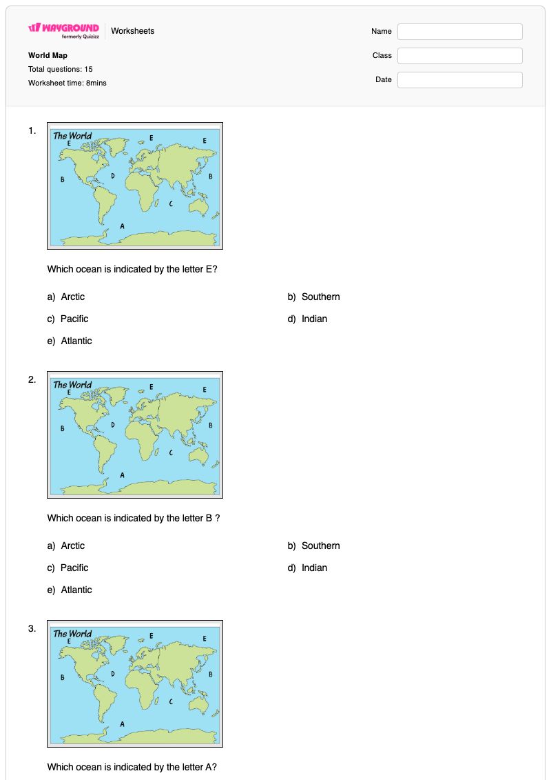
World Map is a free printable Grade 6 geography worksheet that helps students read a labeled world map and identify major physical features. In 15 multiple-choice questions, students match lettered locations to the Arctic, Pacific, Southern, Indian, and Atlantic Oceans and identify the continents represented by map labels, including Asia, North America, Africa, South America, Australia, and Antarctica.
The worksheet also introduces essential map-grid vocabulary. Students distinguish longitude lines from latitude lines and identify the Prime Meridian and Equator by their numbered and colored line labels. This combination of location recognition and map-coordinate practice supports foundational geography review, independent practice, or a quick formative assessment. The worksheet is available as a free printable PDF and includes a complete answer key for efficient checking.
Worksheet settings
Font size
S
M
L
XL
Worksheets
World Map
Total questions: 15
Name
Class
Date
1.
Which ocean is indicated by the letter E?
a)
Arctic
b)
Southern
c)
Pacific
d)
Indian
e)
Atlantic
2.
Which ocean is indicated by the letter B ?
a)
Arctic
b)
Southern
c)
Pacific
d)
Indian
e)
Atlantic
3.
Which ocean is indicated by the letter A?
a)
Arctic
b)
Southern
c)
Pacific
d)
Indian
e)
Atlantic
4.
Which ocean is indicated by the letter C?
a)
Arctic
b)
Southern
c)
Pacific
d)
Indian
e)
Atlantic
5.
Which ocean is indicated by the letter D?
a)
Arctic
b)
Southern
c)
Pacific
d)
Indian
e)
Atlantic
6.
Which continent is indicated by the letter A?
a)
North America
b)
South America
c)
Asia
d)
Europe
e)
Africa
7.
Which continent is indicated by the letter B?
a)
Australia
b)
South America
c)
Asia
d)
Europe
e)
North America
8.
Which continent is indicated by the letter C?
a)
Australia
b)
South America
c)
Africa
d)
Europe
e)
North America
9.
Which continent is indicated by the letter G?
a)
Australia
b)
Europe
c)
South America
d)
Antarctica
e)
Africa
10.
Which continent is indicated by the letter E?
a)
Australia
b)
Europe
c)
Africa
d)
Antarctica
e)
North America
11.
Which continent is indicated by the letter D?
a)
Australia
b)
South America
c)
Africa
d)
Antarctica
e)
North America
12.
Which numbers are longitude line(s)?
a)
2,3,4,5,6
b)
1
c)
1,2,3,4,5,6
13.
Which number(s) represent latitude line(s)?
a)
2,3,4,5,6
b)
1
c)
1,2,3,4,5,6
14.
Which line is the Prime Meridian?
a)
Pink, 3
b)
Green, 1
c)
Red, 2
d)
Yellow, 6
15.
Which line is the Equator ?
a)
Dark Blue, 4
b)
Green, 1
c)
Red, 2
d)
Yellow, 6
Answer Key
World Map
Total questions: 15
1.
a) Arctic
2.
c)
Pacific
3.
b) Southern
4.
d)
Indian
5.
e)
Atlantic
6.
c)
Asia
7.
e)
North America
8.
c)
Africa
9.
c)
South America
10.
a)
Australia
11.
d)
Antarctica
12.
b)
1
13.
a)
2,3,4,5,6
14.
b)
Green, 1
15.
a)
Dark Blue, 4
140 %
Browse by subjects
Browse by grades
Browse by format
FAQs
What does the World Map worksheet cover?
This Grade 6 geography worksheet uses 15 multiple-choice questions to assess whether students can identify five oceans and six lettered continents on a world map. It also asks students to distinguish longitude from latitude and recognize the Prime Meridian and Equator from numbered and colored line labels, building both map-reading accuracy and foundational coordinate vocabulary.
How can I use this worksheet to teach world map features?
Introduce the lettered ocean and continent prompts by having students locate each label on a classroom world map before selecting an answer. Then model the distinction between the single longitude line and the group of latitude lines shown in the worksheet, using the Prime Meridian and Equator questions as a short guided check before students complete the remaining multiple-choice items independently.
What mistakes should I watch for when students complete this world map worksheet?
Watch for students confusing the ocean labels or choosing a nearby continent without first matching the letter to its map location. The coordinate questions may also reveal a reversal of latitude and longitude, or confusion between the Prime Meridian and Equator; ask students to explain what each numbered or colored line represents rather than relying only on answer-choice recognition.
How do I assign and grade this World Map worksheet?
On Wayground, assign it as a printable PDF or as a digital quiz, depending on whether students will mark paper or answer online. The worksheet includes a complete answer key, and printable submissions can be graded by scanning student work with the Wayground for Teachers app.
How can I differentiate this world map worksheet for my students?
Use the worksheet’s Advanced Settings to adjust font spacing or increase the font size so the ocean, continent, and latitude-longitude prompts are easier to read. You can also apply a dyslexia-friendly font or translate the worksheet into another language while keeping its multiple-choice world map format.
Where can I find more worksheets like this on Wayground?
Wayground offers a comprehensive collection of free printable worksheets and practice problems across subjects, with downloadable PDFs and answer keys to support essential skills and concepts. Browse more resources at https://wayground.com/en-us/worksheets.


 Worksheets

