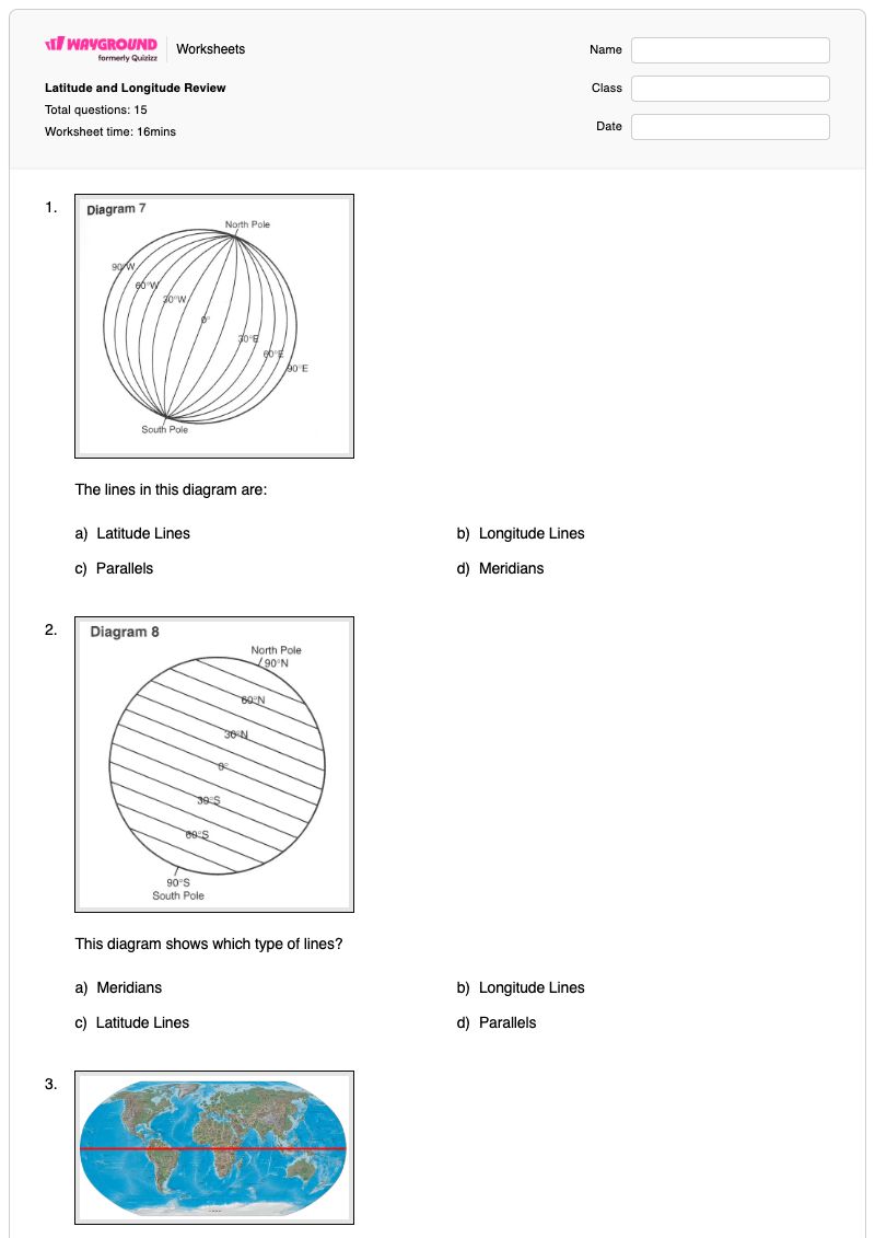

Wayground
Latitude and Longitude Review - Printable Geography Worksheets class 6 - Wayground

Latitude and Longitude Review

15 questions

6th - 6th Grade

Geography

Latitude and Longitude Review is a Grade 6 geography worksheet that builds students’ understanding of Earth’s geographic grid and location vocabulary. Through 15 questions—2 multiple-select and 13 multiple-choice—students identify latitude lines, longitude lines, parallels, and meridians; distinguish the Equator from the Prime Meridian; and explain how hemispheres divide Earth. The worksheet also reviews compass roses, absolute location, and relative location. Students then apply these ideas to read and interpret coordinates, matching locations such as Concord, Carson City, and Springfield with latitude-and-longitude pairs. They also identify approximate locations by correctly ordering north or south latitude and east or west longitude. This free printable worksheet includes an answer key, making it useful for review, independent practice, homework, or a geography assessment.

Worksheet settings

Font size

S
M
L
XL
Worksheets

Latitude and Longitude Review

Total questions: 15

Name
Class
Date
1.

The lines in this diagram are:

a)

Latitude Lines

b)

Longitude Lines

c)

Parallels

d)

Meridians

2.

This diagram shows which type of lines?

a)

Meridians

b)

Longitude Lines

c)

Latitude Lines

d)

Parallels

3.

The red line on this map represents the imaginary line at zero degrees latitude.

a)

Prime Meridian

b)

International Dateline

c)

Equator

d)

Eastern and Western Hemisphere

4.
What is the name of the line at zero degrees longitude?
a)

Equator

b)

Prime Meridian

c)

International Date Line

d)

North Pole

5.
A _______________ is exactly half of the earth.
a)
Equator
b)
Hemisphere
c)
Tropic of Cancer
d)
Arctic Circle
6.

How many hemispheres do the equator and prime meridian divide the earth into?

a)

2

b)

4

c)

6

d)

8

7.
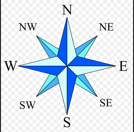
What is this object known as?
a)
map symbol
b)
map key
c)
map scale
d)
compass rose
8.
The invisible line at 0 degrees latitude is called the ________. 
a)
International Date Line
b)
Prime Meridian
c)
Equator
d)
Arctic Circle
9.

Relative location is

a)

Exactly where something is located

b)

Within a mile of where the thing is located

c)

Where something is located compared to some other location or landmark

10.

The precise point on Earth where a particular place can be found is called its ______.

a)

Absolute location

b)

Relative location

c)

distortion

d)

map projection

11.

What coordinates does Concord have?

a)

47n, 77w

b)

35n, 94w

c)

43n, 72w

12.

What has the coordinates of 38, 120w?

a)

Carson City

b)

Salt Lake City

c)

Helena

13.

What coordinates match Springfield?

a)

45n, 75w

b)

40n, 90w

c)

50n 100w

14.
What is the approximate location of G?
a)
100oW, 40oN
b)
40oN, 100oW
c)
40oS, 100oW
d)
40oN, 100oE
15.
Which of the following letter is at approximately 60 degrees S, 40 degrees W? 
a)
A
b)
D
c)
E
d)
H
Answer Key

Latitude and Longitude Review

Total questions: 15

1.
b)

Longitude Lines

, d)

Meridians

2.
c)

Latitude Lines

, d)

Parallels

3.
c)

Equator

4.
b)

Prime Meridian

5.
b) Hemisphere
6.
b)

4

7.
d) compass rose
8.
c) Equator
9.
c)

Where something is located compared to some other location or landmark

10.
a)

Absolute location

11.
c)

43n, 72w

12.
a)

Carson City

13.
b)

40n, 90w

14.
b) 40oN, 100oW
15.
b) D

FAQs

What does the Latitude and Longitude Review worksheet cover?

This Grade 6 geography worksheet uses 2 multiple-select and 13 multiple-choice questions to review latitude and longitude concepts. Students identify parallels, meridians, the Equator, and the Prime Meridian; distinguish absolute from relative location; recognize a compass rose; and use coordinate pairs to identify places and approximate map locations.

How can I use this worksheet to teach latitude and longitude?

Introduce the worksheet by having students sort the line terms—latitude, longitude, parallels, and meridians—and then connect the Equator and Prime Meridian to zero degrees. After reviewing absolute and relative location, have students explain how they read the coordinate pairs in the Concord, Carson City, Springfield, and letter-location questions, including why latitude is listed before longitude.

What mistakes should I watch for on this latitude and longitude worksheet?

Students may confuse latitude lines with longitude lines, or treat parallels and meridians as unrelated terms rather than equivalent names. Watch for students reversing latitude and longitude in coordinate pairs, confusing the Equator with the Prime Meridian, or selecting relative location when a question asks for a precise absolute location.

How do I assign and grade this worksheet?

Latitude and Longitude Review is available as a printable PDF and as a digital quiz on Wayground, so you can choose paper practice or online completion. It includes a complete answer key for checking the line-identification, vocabulary, and coordinate questions. Printable submissions can also be graded by scanning student work with the Wayground for Teachers app.

How can I differentiate this latitude and longitude worksheet for my students?

Use the worksheet’s Advanced Settings to adjust font spacing or font size so the line-identification and coordinate questions are easier to read and navigate. You can also enable a dyslexia-friendly font or translate the worksheet into another language when that better supports students working with the geographic vocabulary.

Where can I find more worksheets like this on Wayground?

Wayground offers a broad collection of free printable worksheets and practice problems across subjects, with downloadable PDFs and answer keys to help students master essential skills and concepts. Browse more resources at https://wayground.com/en-us/worksheets.