
 Worksheets
UAG Earth Sci - Interim Assessment 3 Review
Total questions: 15
Worksheet time: 16mins
Name
Class
Date
1.

The ozone layer protects life on Earth by absorbing harmful ultraviolet radiation. The ozone layer is located between 17 kilometers and 35 kilometers above Earth’s surface in which atmospheric temperature zone?
a)
troposphere
b)
stratosphere
c)
mesosphere
d)
thermosphere
2.

Which weather map symbol is associated with extremely low air pressure?
a)
SYMBOL 1
b)
SYMBOL 2
c)
SYMBOL 3
d)
SYMBOL 4
3.

What is the approximate P-wave travel time from an earthquake if the P-wave arrives at the seismic station 8 minutes before the S-wave?
a)
4 minutes 20 seconds
b)
6 minutes 30 seconds
c)
10 minutes 0 seconds
d)
11 minutes 20 seconds
4.
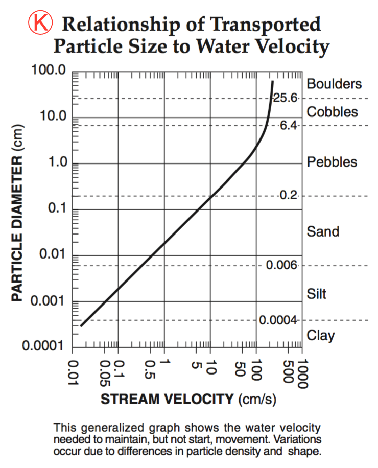
What is the minimum water velocity necessary to maintain movement of 0.1-centimeter-diameter particles in a stream?
a)
5.0 cm/s
b)
0.02 cm/s
c)
0.5 cm/s
d)
20.0 cm/s
5.
What is the minimum water velocity necessary to maintain movement of 0.1-centimeter-diameter particles in a stream?
a)
5.0 cm/s
b)
0.02 cm/s
c)
0.5 cm/s
d)
20.0 cm/s
6.
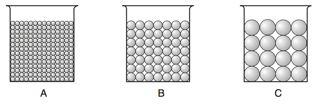
The cross sections below represent three beakers that were used to test porosity. Beakers A, B, and C each contain a different size of bead. Each beaker holds an equal volume of beads. The amount of water needed to fill the total pore space between the beads in each beaker was measured.
Which statement best describes the porosity that was found for these three samples?
Which statement best describes the porosity that was found for these three samples?
a)
A had a greater porosity than B and C.
b)
B had a greater porosity than A and C.
c)
C had a greater porosity than A and B.
d)
All three samples had the same porosity.
7.
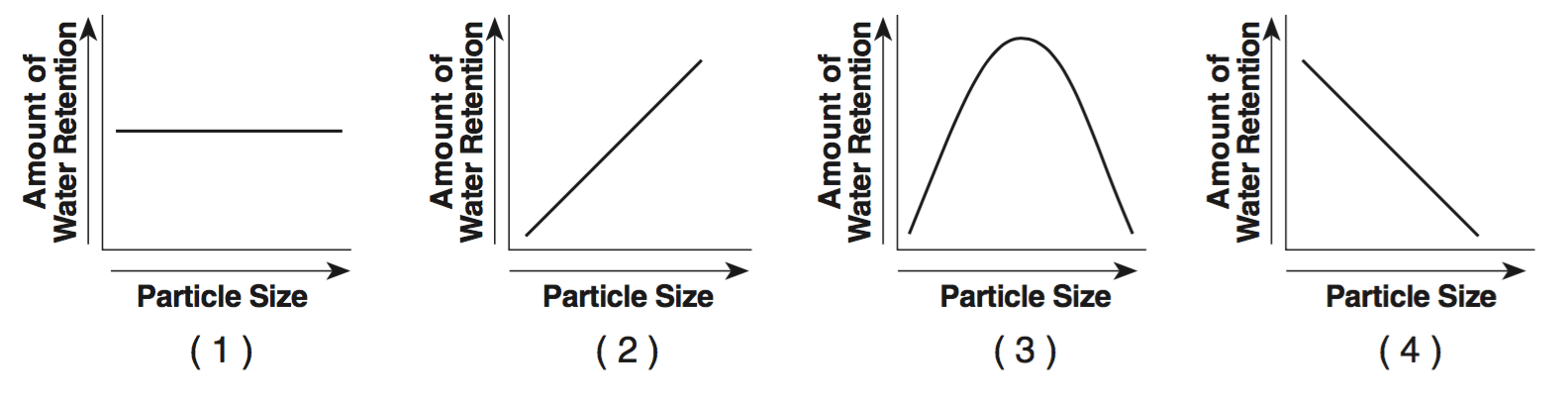
Which graph best indicates the general relationship between soil particle size and the amount of water retention by a permeable soil?
a)
GRAPH 1
b)
GRAPH 2
c)
GRAPH 3
d)
GRAPH 4
8.
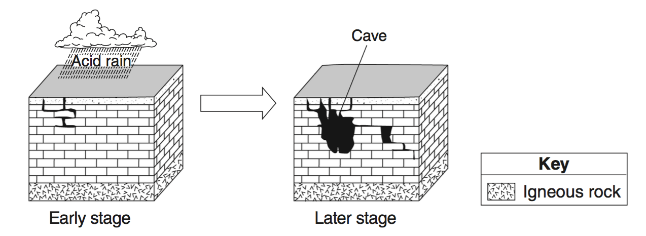
The two block diagrams below represent the formation of caves.
Which types of weathering and erosion are primarily responsible for the formation of caves?
Which types of weathering and erosion are primarily responsible for the formation of caves?
a)
chemical weathering and groundwater flow
b)
chemical weathering and runoff
c)
physical weathering and groundwater flow
d)
physical weathering and runoff
9.

Which diagram represents a side view of a sand dune most commonly formed as a result of the prevailing wind direction shown?
a)
DIAGRAM 1
b)
DIAGRAM 2
c)
DIAGRAM 3
d)
DIAGRAM 4
10.

The map below indicates an air-pressure field over North America. Isobar values are recorded in millibars.
At which city was the greatest wind speed occurring?
At which city was the greatest wind speed occurring?
a)
Boise
b)
Denver
c)
Kansas City
d)
Austin
11.

The boxes labeled A through G represent rocks and rock materials. Arrows represent the processes of the rock cycle.
Which lettered box could represent the rock conglomerate?
Which lettered box could represent the rock conglomerate?
a)
E
b)
G
c)
C
d)
D
12.

Which rock is composed of the mineral halite that formed when seawater evaporated?
a)
rock salt
b)
limestone
c)
rock gypsum
d)
dolostone
13.

Which mineral is mined for its iron content?
a)
hematite
b)
fluorite
c)
galena
d)
talc
14.

Compared to the surrounding material, mantle plumes rise toward Earth’s surface from the core-mantle boundary because they are
a)
cooler and less dense
b)
hotter and less dense
c)
cooler and more dense
d)
hotter and more dense
15.

At which depth below Earth’s surface is the boundary between Earth’s outer core and stiffer mantle located?
a)
700 km
b)
2000 km
c)
2900 km
d)
5100 km
100 %

