
 Worksheets
Africa Map & Physical GY
Total questions: 24
Worksheet time: 12mins
Name
Class
Date
1.
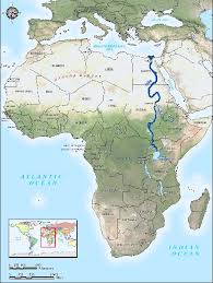
What river is highlighted? This is the longest river on earth from North to South.
a)
Congo
b)
Zambezi
c)
Nile
d)
Amazon
2.
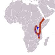
What geographic feature is highlighted? It is a ridge & plate boundary with lots of volcanic activity beneath its surface. Millions of years from now, it will split the continent in half.
a)
Sahel
b)
Transition Zone
c)
Ring of Fire
d)
Great Rift Valley
3.
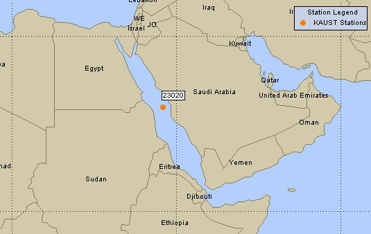
What body of water is shown on the map? It is narrow and separates Africa from the Arabian peninsula (Asia).
a)
Straits of Comoros
b)
Red Sea
c)
Dead Sea
d)
Mediterranean Sea
4.

What geographic feature is shown on the map? It marks the transition between Sahara Desert and the more hospitable savanna region.
a)
Great Rift Valley
b)
step
c)
Sahel
d)
Atlas Mountains
5.

What country is highlighted? Its capital is Nairobi. The equator crosses through the nation.
a)
Ethiopia
b)
Kenya
c)
South Africa
d)
Sudan
6.

What country is highlighted? The official language is Portuguese. Its capital is Luanda and it is a self-declared communist state.
a)
Namibia
b)
Mali
c)
Angola
d)
Botswana
7.

What small country is highlighted? It is known for its diamond mines. The landscape is dominated by the Kalahari desert.
a)
South Africa
b)
Nigeria
c)
Democratic Republic of the Congo
d)
Botswana
8.

What country is highlighted? It has the largest economy and population in Africa.
a)
Ethiopia
b)
Nigeria
c)
South Africa
d)
Ghana
9.

What country is highlighted? Its capital is Addis Ababa. The majority of the population is Orthodox Christian, and it is one of two countries on earth (the other being Russia) to have never been occupied by another power.
a)
Ethiopia
b)
Somalia
c)
Libya
d)
Mali
10.

What country is highlighted? It is the 2nd largest country in Africa in terms of land area (after Algeria). It has been in a state of civil war since the 90s.
a)
Angola
b)
Democratic Republic of the Congo
c)
Senegal
d)
Uganda
11.

What small country is highlighted on the map? Its capital is Dakar.
a)
Morocco
b)
Gambia
c)
Equatorial Guinea
d)
Senegal
12.

What country is highlighted here? Its capitol is Cairo.
a)
Morocco
b)
Egypt
c)
Sudan
d)
Algeria
13.
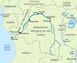
What river is highlighted? It flows through heavily forested regions in the center of the African continent.
a)
Congo
b)
Zambezi
c)
Kasai
d)
Nile
14.

Which of the following is NOT one of the reasons coastal West Africa is able to support larger populations than inland West Africa?
a)
fishing
b)
more rainfall
c)
mining industries
d)
more opportunities for trade
15.

What is the main geographic feature of Central Africa?
a)
The Congo River Basin & rainforest
b)
Nile River Valley
c)
Kalahari Desert
d)
Sahel region
16.

Why is the soil of the Great Rift Valley so rich in nutrients & good for growing crops?
a)
dust deposits from the Sahara Desert
b)
all the animals help fertilize the land
c)
volcanic activity
d)
annual flooding of the major rivers
17.

How do the majority of people in a typical landlocked country on the steppes of Africa, Chad, make their living?
a)
herding cattle
b)
subsistence farming
c)
fishing
d)
tourism
18.

Which country depends on hydro-electric power from the Congo River?
a)
The Democratic Republic of the Congo
b)
Cameroon
c)
Nigeria
d)
Angola
19.

How did the Bantu peoples gain an advantage over other groups as they moved from their homeland in Central Africa to other regions of the continent?
a)
better access to deposits of gold
b)
their homeland had better soil for growing crops
c)
traveled in caravans for safety
d)
knowledge of iron-working and new weapons
20.

What is a lingua franca? Swahili is an example.
a)
a type of weapon
b)
a common currency
c)
a common language used across different groups of people
d)
a storytelling method
21.

What 2 goods allowed West African empires such as Ghana to prosper during the Middle Ages?
a)
coffee and olives
b)
gold and salt
c)
diamonds and emeralds
d)
silver and copper
22.

What about South Africa’s climate helps it support a wide variety of crops, such as apples, bananas, grapes, wheat and corn?
a)
the climate is dry and warm
b)
it is temperate with 4 distinct seasons
c)
it has a wet season (monsoons) and dry season
d)
it is tropical and humid
23.

What does a griot do?
a)
work as a farmer
b)
tell poems/stories & help keep track of oral history
c)
rule city-states in the Sahel region
d)
make elaborate clothes
24.

What do organizations like the African Union do?
a)
provide for common defense
b)
promote trade in the region
c)
try to control the value of currency
100 %

