
 Worksheets
Physical Features
Total questions: 23
Worksheet time: 13mins
Name
Class
Date
1.

Which landform/physical feature borders the Atlantic Ocean and the Gulf of Mexico?
a)
The Continental Divide
b)
Atlantic Ocean
c)
Atlantic Coastal Plain
d)
Appalachian Mountain
2.

This body of water is located between Mexico and Florida.
a)
Erie Canal
b)
Continental Divide
c)
Gulf of Mexico
d)
St. Lawrence River
3.

This landform and physical feature is a desert with high temperatures and little rainfall.
a)
Continental Divide
b)
Erie Canal
c)
Great Lakes
d)
Death Valley
4.
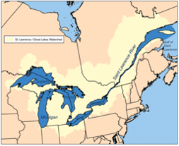
This river flows through northeastern Canada to the Great Lakes.
a)
Lake Lanier
b)
St. Lawrence River
c)
Atlantic Ocean
d)
Erie Canal
5.

The high peaks(mountain tops) of the Rocky Mountains form an imaginary line in the United States known as
a)
Death Valley
b)
Continental Divide
c)
Rocky Mountains
d)
Great Plains
6.

Which landform and physical feature is located west of the Rocky Mountains?
a)
Rocky Mountains
b)
Mississippi River
c)
Gulf Of Mexico
d)
Great Basin
7.

This landform and physical features has very few trees and lots of grassland
a)
Great Plains
b)
Continental Divide
c)
Great Basin
d)
Death Valley
8.

These bodies of water are connected to each other and contain fresh water
a)
Great Lakes
b)
St. Lawrence River
c)
Gulf of Mexico
d)
Atlantic Ocean
9.
Which is the lowland bordering the Atlantic Ocean with excellent harbors?
a)
Gulf of Mexico
b)
Great Basin
c)
St. Lawrence River
d)
Atlantic Costal Plain
10.
Which is a flat area in the mid-United States made up of grasslands with no trees?
a)
Great Basin
b)
Great Plains
c)
Death Valley
d)
Great Lakes
11.
Which is an area west of the Rocky Mountains and east of the Sierra Nevada? There are high peaks and low valleys here.
a)
St. Lawrence River
b)
Great Plains
c)
Great Basin
d)
Death Valley
12.
This River is an important transportation route for large ships.
a)
Erie Canal
b)
Catooga River
c)
St. Lawrence River
d)
Gulf of Mexico
13.
This waterway allows goods to be transported easily along the Great Lakes.
a)
St. Lawrence River
b)
Great Lakes
c)
Gulf of Mexico
d)
Erie Canal
14.
This large area of water has warmer water than the oceans.
a)
Great Basin
b)
Gulf of Mexico
c)
Atlantic Coastal Plain
d)
Erie Canal
15.
This area is a desert with high temperatures and low annual rainfall.
a)
Continental Divide
b)
Erie Canal
c)
Great Lakes
d)
Death Valley
16.
This river flows through northeastern Canada.
a)
Lake Lanier
b)
St. Lawrence River
c)
Atlantic Ocean
d)
Erie Canal
17.

Tallest mountain chain in North America
a)
Appalachians
b)
Coastal Range
c)
Rockies
d)
St. Lawrence
18.

What large mountain range is pictured here?
a)
Catskill Moutains
b)
Rocky Moutanins
c)
Appalachian Mountains
19.
How many Great Lakes are there?
a)
3
b)
4
c)
5
d)
6
20.
Which region of the United States contains the Great Plains?
a)
Northeast
b)
South
c)
Midwest
d)
West
21.
An area in southeastern California that is the lowest, driest, and hottest part of the United States
a)
Great Plains
b)
Death Valley
c)
Continental Divide
d)
Great Basin
22.
A natural geographic feature on Earth's surface, such as a mountain or plateau
a)
Landform
b)
Rocky Mountains
c)
Appalachian Mountains
d)
Continental Divide
23.
Completed in 1825 (took 8 years to build); connects the Great Lakes with the Atlantic Ocean, via the Mohawk and Hudson Rivers in New York
a)
Boston
b)
New York City
c)
St. Lawrence River
d)
Erie Canal
100 %

