
 Worksheets
Unit 1 Test Practice
Total questions: 34
Worksheet time: 24mins
Name
Class
Date
1.
SS8G1a) All of the states border Georgia EXCEPT for _______________.
a)
Mississippi
b)
Alabama
c)
Florida
d)
Tennessee
2.
(SS8G1a) Georgia is located in what region of the United States?
a)
Midwest
b)
Northeast
c)
Southeast
d)
Southwest
3.
(SS8G1a) How many physical/physiographic regions does Georgia have?
a)
1
b)
7
c)
4
d)
5
4.
(SS8G1b) Which of the following is the smallest physiographic region in Georgia?
a)
Blue Ridge
b)
Coastal Plain
c)
Appalachian Plateau
d)
Ridge and Valley
5.
(SS8G1b) Which region is Georgia's only source of coal?
a)
Appalachian Plateau
b)
Ridge and Valley
c)
Blue Ridge
d)
Coastal Plain
6.
(SS8G1c) What is the highest peak in Georgia?
a)
Brasstown Bald
b)
Stone Mountain
c)
Lookout Mountain
d)
Signal Moutain
7.
(SS8G1d) Weather patterns over an extended period of time are referred to as
a)
temperature patterns
b)
extended forecasts
c)
climate
8.
(SS8G1d) Because of its warm weather and sunny beaches, beach-goers would most likely be attracted to which physiographic region?
a)
Coastal Plain
b)
Ridge and Valley
c)
Appalachian Plateau
d)
Blue Ridge
9.
(SS8G1c) Body of water that runs through Atlanta and makes up part of Georgia's border with Alabama is?
a)
Savannah
b)
Tennessee
c)
Chattahoochee
d)
Yellow River
10.
(SS8G1c) This freshwater marsh is located in the Coastal Plain region of Georgia.
a)
Everglades
b)
Ogeechee
c)
Okefenokee
11.
(SS8G1b) Site of the very 1st Gold rush, has the highest amount of annual rainfall, has the highest point (Brasstown Bald)
a)
Ridge and Valley
b)
Piedmont
c)
Coastal Plain
d)
Blue Ridge
12.
(SS8G1c) What physical feature in Georgia built forts to protect Georgia from pirates and the Spanish, but now protects the interior of Georgia from bad weather and is popular for tourism?
a)
Barrier Islands
b)
Savannah River
c)
Chattahoochee
d)
Appalachian Mountains
13.
(SS8G1c) Borders GA and SC, Helps transport goods, Yamacraw Indians were settled here
a)
Barrier Islands
b)
Savannah River
c)
Chattahoochee
d)
Appalachian Mountains
14.
(SS8G1c) Which of the following does NOT describe the Appalachian Mountains?
a)
Only region for coal
b)
It runs through 3 of Georgia�s Northern most regions.
c)
Site of the 1st Gold Rush in Dahlonega in 1828
d)
Is the industrial heart of Georgia
15.
(SS8G1a) Georgia is located in what country?
a)
United States
b)
North American
c)
Southeast
d)
Asia
16.
(SS8G1a) Georgia is located on what continent?
a)
United States
b)
North American
c)
Southeast
d)
Asia
17.
The "Fall Line" is the dividing point between which two geographic regions in Georgia?
a)
Blue Ridge and Piedmont
b)
Piedmont and Coastal Plain
c)
Blue Ridge and Valley & Ridge
d)
Appalachian and Valley & Ridge
18.
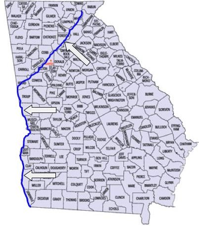
The blue line represents what Georgia river?
a)
Flint
b)
Savannah
c)
Ocmulgee
d)
Chattahoochee
19.
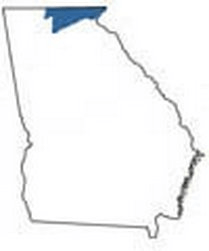
What region is this?
a)
Piedmont
b)
Ridge and Valley
c)
Coastal Plains
d)
Blue Ridge
20.
This region has the largest population.
a)
Coastal Plains
b)
Piedmont
c)
Blue Ridge Mountains
d)
Appalachian Plateau
21.
Why are employees more willing to relocate to GA?
a)
Temperate/Mild Climate
b)
Higher standard of living
c)
Higher cost of living
d)
Lowest taxes in the nation
22.
(SS8G1c) This freshwater marsh is located in the Coastal Plain region of Georgia.
a)
Everglades
b)
Ogeechee
c)
Okefenokee
23.
(SS8G1a) Georgia is located in each of the following hemispheres EXCEPT for the
a)
Eastern
b)
Northern
c)
Western
24.
How does Georgia's climate help its economy?
a)
The mountains attract millions of tourists each year for their world famous snow skiing.
b)
Atlanta has grown into the premier city in the Southeast and offers a wide variety of jobs.
c)
Long growing seasons and adequate moisture in most years allow a wide variety of crops to be produced.
d)
Rivers and roadways provide much needed transportation routes for distribution of goods produced there.
25.
Oconee County is located in the _________ region.
a)
Coastal Plain
b)
Blue Ridge
c)
Piedmont
d)
Appalachian Plateau
26.
When measuring the lines of longitude, always begin with the _______, which represents 0 degrees.
a)
South Pole
b)
Equator
c)
Prime Meridian
d)
Latitude
27.

What is the name of this line at 0 degrees latitude?
a)
Prime Meridian
b)
Equator
c)
North Pole
d)
South Pole
28.

What is the name of the line at zero degrees longitude?
a)
Equator
b)
Prime Meridian
c)
North Pole
d)
South Pole
29.
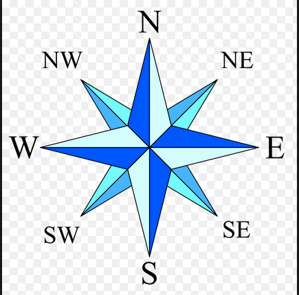
What is this object known as?
a)
map symbol
b)
map key
c)
map scale
d)
compass rose
30.
This location tells you EXACTLY where something is
a)
absolute location
b)
relative location
31.
this location tells you were something is in relation to something else
a)
absolute location
b)
relative location
32.
Keys words for relative location are
a)
north, close to, far, next to
b)
addresses, latitude and longitude
33.
When looking for absolute location, look for:
a)
north, close to, far, beside
b)
addresses and latitude and longitude
34.
Lines of latitude and longitude will give you
a)
absolute location
b)
relative location
100 %

