
 Worksheets
Physical and Political Geography of Southwest Asia
Total questions: 11
Worksheet time: 7mins
Name
Class
Date
1.
Which bodies of water are connected by the Strait of Hormuz?
a)
The Red Sea and the Arabian Sea
b)
The Persian Gulf and the Arabian Sea
c)
The Mediterranean Sea and the Red Sea
d)
The Mediterranean Sea and the Persian Gulf
2.
The Tigris and Euphrates rivers come together to form the border between which countries?
a)
Turkey and Iraq
b)
Kuwait and Iran
c)
Saudi Arabia and Israel
d)
Iraq and Saudi Arabia
3.
Why is the Suez Canal so important to international shipping?
a)
The Suez Canal is Iraq’s only waterway leading into the Persian Gulf
b)
. The Suez Canal is the only way for ships to get out of the Persian Gulf
c)
. The Suez Canal makes it possible to get to the Mediterranean Sea from the Arabian Sea without having to sail around the continent of Africa.
d)
The Suez Canal connects the Jordan River to the Persian Gulf, making it less expensive to ship products to other parts of Southwest Asia
4.
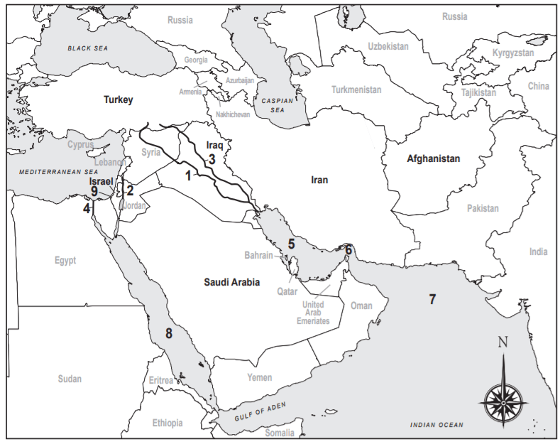
Which Marks the Suez Canal?
a)
1
b)
2
c)
3
d)
4
5.
Which marks the Red Sea?
a)
5
b)
6
c)
7
d)
8
6.
Which is marked with a "9"
a)
Dead Sea
b)
Gaza Strip
c)
Tigris River
d)
Euphrates River
7.
Which is marked with a "1"
a)
Dead Sea
b)
Gaza Strip
c)
Tigris River
d)
Euphrates River
8.
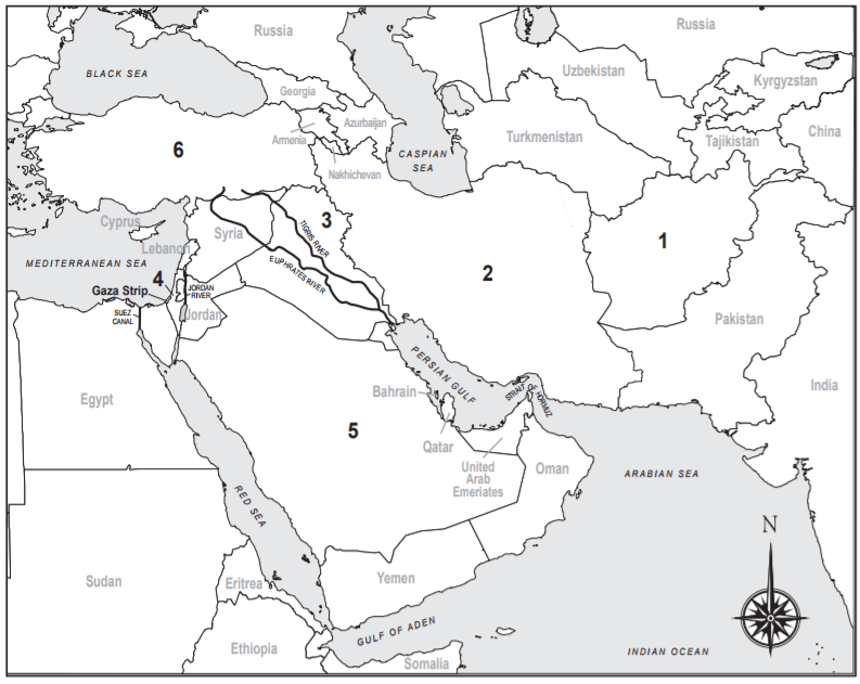
Which number marks Israel?
a)
1
b)
2
c)
3
d)
4
9.
Which number marks Iraq?
a)
2
b)
3
c)
4
d)
6
10.
Which number marks Saudi Arabia?
a)
1
b)
4
c)
5
d)
6
11.
Which country is marked by a “6”?
a)
Iran
b)
Turkey
c)
Jordan
d)
Afghanistan
100 %

