wayground logo

Free Printable Worksheets

Font size

S
M
L
XL
Worksheets

Maps

Total questions: 43

Worksheet time: 43mins

Name
Class
Date
1.

If we split the world into half, it is called a ________________.

a)

longitude

b)

latitude

c)

hemisphere

d)

equator

2.

What are imaginary lines that cross the globe from North to South?

a)

Longitude

b)

Latitude

c)

Equator

d)

Prime Meridian

3.

What is an imaginary line of longitude running from the North and South Pole at 0 degrees longitude called?

a)

Equator

b)

Prime Meridian

c)

Longitude

d)

Latitude

4.

What is an imaginary line of latitude running around the Earth at 0 degrees latitude?

a)

Prime Meridian

b)

Equator

c)

Latitude

d)

Longitude

5.
A flat picture of land.
a)
Map
b)
Globe
6.

What is a round model of the Earth?

a)

globe

b)

hemisphere

c)

compass rose

d)

inset map

7.

What is the kind of map that shows the types of landforms?

a)

Political Map

b)

Physical Map

c)

Inset Map

8.

What tells what the symbols on the map stand for?

a)

Globe

b)

Map key

c)

Compass Rose

9.

What is the name of the drawing that tells you the directions on a map?

a)

Map Key

b)

Compass Rose

c)

Inset Map

10.

North West, North East, South East, South West are called what type of directions?

a)

Inset Map

b)

Intermediate Directions

c)

Cardinal Directions

11.
What is this? 
a)
This is a compass rose.
b)
This is a map scale.
c)
This is a key.
12.
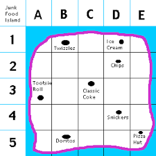
What is located in E5?
a)
Twizzles
b)
Ice Cream
c)
Chips
d)
Pizza Hut
13.
How many miles would 9 inches be on this map?
a)
10
b)
20
c)
30 
d)
90
14.
What is the purpose of a map scale?
a)
To weigh the political power of the states
b)
To show where things are located on the map
c)
Compare the distance measured on the map to the actual distance on Earth
d)
To show how large the map is
15.
What type of map is being shown?
a)
Physical Map
b)
Time Zone Map
c)
Elevation Map
d)
Inset Map
16.
A __________ map shows landforms and other geographic features.
a)
Road
b)
Physical
c)
Political
d)
Locator
17.
What type of map shows borders between states and countries?
a)
Road Map
b)
Physical Map
c)
Time Zone Map
d)
Political Map
18.
One of 4 directions that are midway between the cardinal directions.
a)
Intermiddle directions
b)
Mediate directions
c)
Intermediate directions
d)
Cardinal directions
19.
A _____ tells us what the map is about.
a)
Summary
b)
Story
c)
Title
d)
Conclusion
20.
What is the map scale used to figure out? 
a)
the number of countries on the map
b)
which direction is north, south, east and west
c)
the real distance between places on the map
d)
what the map symbols mean
21.
What kind of map would you use to see what people thought the world looked like 500 years ago? 
a)
a physical map
b)
a military map
c)
a historical map
d)
an agricultural map
22.
If you wanted to know the symbol for "river," where on a map would you look? 
a)
the scale
b)
the compass rose
c)
the borders
d)
the legend
23.
If you wanted to find out the average temperature in Africa, what kind of map would you use? 
a)
an agricultural map
b)
a physical map
c)
a climate map
d)
a political map
24.
What type of map is shown in the picture?
a)
Resource 
b)
Physical 
c)
Climate
d)
Topographical 
25.
Use the map to determine which type is shown.
a)
Trade
b)
Resource
c)
Political
d)
Population
26.
What kind of map can you use to determine an areas average temperatures and precipitation?
a)
Climate
b)
Resource
c)
Trade
d)
Physical
27.
Where is the Eastern Hemisphere located?
a)
Above the Equator
b)
Below the Equator
c)
To the right of the Prime Meridian
d)
To the left of the Prime Meridian
28.
What unit do we use to measure lines of latitude and longitude?
a)
Degrees
b)
Miles
c)
Feet
d)
Inches
29.
Where is the Northern Hemisphere located?
a)
Above the Equator
b)
Below the Equator
c)
To the right of the Prime Meridian
d)
To the left of the Prime Meridian
30.
Absolute location uses coordinates like
a)
Next to
b)
North of
c)
Around
d)
Latitude and Longitude
31.
Cartographers cannot make perfect representations of the Earth on maps because of 
a)
The weather
b)
Satellite Images
c)
Distortion
d)
The Earth is huge
32.
This location tells you EXACTLY where something is
a)
absolute location
b)
relative location
33.
this location tells you were something is in relation to something else
a)
absolute location
b)
relative location
34.
Keys words for relative location are
a)
north, close to, far, next to
b)
addresses, latitude and longitude
35.
When looking for absolute location, look for:
a)
north, close to, far, beside
b)
addresses and latitude and longitude
36.
50° North, 50 ° East
a)
absolute location
b)
relative location
37.
I live near the bus stop
a)
absolute location
b)
relative location
38.
Latitude lines MEASURE the distance  __________ and ________ of the equator.
a)
North and South
b)
East and West
39.
Longitude lines measure the distance _________ and ___________ of the prime meridian.
a)
North and South
b)
East and West
40.
 North, South, East, West are what type of directions?
a)
Cardinal Directions
b)
Intermediate Directions
c)
Absolute
d)
Relative
41.

The study of the earth and everything on it:

a)

Geography

b)

Absolute Location

c)

Relative Location

d)

Distortion

42.

5. Distortion is...

a)

where a place is located compared to another place

b)

different ways of representing Earth on a flat surface or map

c)

a change in the shape or size of a place when representing earth on a flat map

d)

the exact location of someplace on Earth

43.
What city is located at about 39 degrees North latitude and 108 degrees West longitude?
a)
Durango
b)
Delta
c)
Boulder
d)
Denver