
NEW
Font size
S
M
L
XL
 Worksheets
Meandering Stream & Glaciers Quiz
Total questions: 15
Worksheet time: 15mins
Name
Class
Date
1.
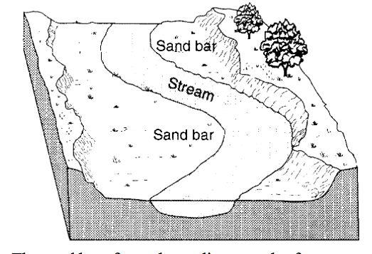
The diagram below shows a portion of a stream. The sand bar formed as a direct result of
a)
erosion due to a decrease in stream velocity
b)
erosion due to an increase in stream velocity
c)
deposition due to a decrease in stream velocity
d)
deposition due to an increase in stream velocity
2.
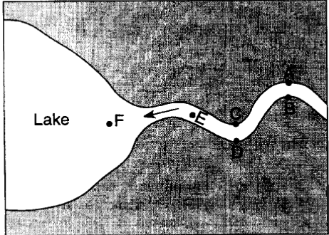
The map below represents a river as it enters a lake.
At which locations is the amount of deposition greater than the amount of erosion?
At which locations is the amount of deposition greater than the amount of erosion?
a)
A,C and E
b)
B, D and F
c)
B, C, and F
d)
A, D and E
3.
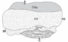
The map below shows an overhead view of sediments that have accumulated at the bottom of a lake. Points A through D represent locations on the shoreline of the lake. A river most likely flows into the lake nearest to location
a)
A
b)
B
c)
C
d)
D
4.
Sediments are deposited in a river delta because the
a)
velocity of the river decreased
b)
force of gravity decreased
c)
volume of the river increases
d)
gradient of the river increases
5.
The entire area drained by a river and its tributaries is called a
a)
Delta
b)
Watershed
c)
Valley
d)
Floodplain
6.
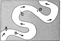
At which location is the greatest amount of sediment most likely being deposited?
a)
A
b)
B
c)
C
d)
D
7.
Trees growing on the edge of a river's meander are most likely to fall into the river due to
a)
deposition on the inside of the meander
b)
deposition on the outside of the meander
c)
erosion on the inside of the meander
d)
erosion on the outside of the meander
8.
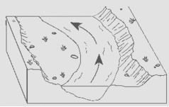
The diagram below shows a section of a meander in a stream. The arrow shows the direction of stream flow. The stream bank on the outside of this meander is steeper than than the stream bank on the inside of this meander because the water on the outside of the meander is moving
a)
Slower, causing deposition
b)
Faster, causing deposition
c)
Slower, causing erosion
d)
Faster, causing erosion
9.
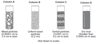
The columns A, B, C, and D shown below contain equal volumes of sediment. When an equal volume of water is added to each column, the greatest rate of infiltration will occur in which column?
a)
A
b)
B
c)
C
d)
D
10.
A stream’s velocity decreases from 100 cm/s to 5cm/s. Which size sediment particles will still be transported by the stream?
a)
pebbles, sand, silt and clay
b)
sand, silt and clay only
c)
silt and clay only
d)
clay only
11.
Flash flooding often occurs in city areas because
a)
runoff decreases during preciptiation
b)
ground water storage is usually very large
c)
roads, pavements and buildings reduce the infiltration of water into the ground
d)
the heat generated by the city areas decreases actual evapotranspiration
12.
During a rainstorm, when the soil becomes saturated, the amount of infiltration
a)
decreases and runoff decreases
b)
decreases and runoff increases
c)
increases and runoff decreases
d)
increases and runoff increases
13.

The diagram below shows a hand-sized rock sample with parallel sets of grooves. This rock sample was found in a gravel bank in central Vermont.
a)
stream erosion
b)
wind erosion
c)
landslide
d)
glacial erosion
14.

The diagram below represents a side view of a hill (drumlin) that was deposited by a glacier on the Atlantic coast. The hill is most likely composed of
a)
cemented sediments
b)
unsorted sediments
c)
vertically layered sediments
d)
horizontally layered sediments
15.

The diagram below shows a glacial landscape feature forming over time from a melting block of ice. This glacial landscape feature is best identified as
a)
kettle lake
b)
outwash plain
c)
finger lake
d)
moraine
Reset

