
 Worksheets
Unit 1 Study
Total questions: 47
Worksheet time: 50mins
Name
Class
Date
1.
Latitude lines run
a)
East to West
b)
North to South
2.
This line measures 0 degrees longitude:
a)
Equator
b)
International Date Line
c)
Meridians
d)
Prime Meridian
3.
The 0 degree line of latitude is the ___________.
a)
Equator
b)
Prime Meridian
c)
International Date Line
d)
Contour line
4.

What is the approximate location of letter B?
a)
80oN, 0o
b)
0o, 80oW
c)
80oS, 0o
d)
0o, 80oE
5.

Which letter would you find at 15oS, 60oW?
a)
A
b)
C
c)
L
d)
H
6.

What is this object known as?
a)
map symbol
b)
map key
c)
map scale
d)
compass rose
7.

What is the latitude of New Orleans?
a)
90*W
b)
30*N
c)
30*W
d)
90*E
8.

What kind of map is this?
a)
Continental
b)
Political
c)
Flat
d)
Globe
9.
What is a map scale?
a)
a tool to measure distance
b)
a tool to tell direction
c)
a tool to start a fire
d)
a tool to build a house
10.
Indicates the location of landforms like deserts, mountains, and plains
a)
Intermediate directions
b)
Prime Meridian
c)
Physical Map
d)
Map key/Legend
11.
Explains what the symbols on a map represent
a)
Bar Scale
b)
Map Key/Legend
c)
Compass Rose
d)
Parallels
12.

Is this showing latitude or longitude?
a)
Latitude
b)
Longitude
13.

Is this showing latitude or longitude?
a)
Latitude
b)
Longitude
14.
Latitude is measured out from what?
a)
Equator
b)
Prime Merididan
c)
International Date Line
d)
United States
15.
Longitude is measured out from what?
a)
Equator
b)
Prime Meridian
c)
International Date Line
d)
United States
16.
Latitude and longitude are measured in what?
a)
Inches
b)
Kilometers
c)
Degrees
d)
Gallons
17.
Is latitude measured in degrees north and south OR degrees east and west?
a)
North and South
b)
East and West
18.
Is longitude measured in degrees north and south OR degrees east and west?
a)
North and South
b)
East and West
19.
Which runs horizontally around the earth?
a)
Equator and lines of latitude
b)
Prime Meridian and lines of latitude
c)
Equator and lines of longitude
d)
Prime Meridian and lines of longitude
20.
Which runs vertically around the earth?
a)
Equator and lines of latitude
b)
Prime Meridian and lines of latitude
c)
Equator and lines of longitude
d)
Prime Meridian and lines of longitude
21.
Latitude lines on a globe measure from-
a)
north to south
b)
east to west
c)
north to east
d)
south to west
22.
_______ lines on a globe run from east to west.
a)
North Pole
b)
South Pole
c)
Latitude
d)
Longitude
23.
When measuring the lines of latitude, always begin with the ______, which represents 0
degrees.
degrees.
a)
Prime Meridian
b)
Equator
c)
Longitude
d)
North Pole
24.
When measuring the lines of longitude, always begin with the _______, which represents 0 degrees.
a)
South Pole
b)
Equator
c)
Prime Meridian
d)
Latitude
25.
On a globe, the Equator is the
a)
Horizontal, center line
b)
Vertical, center line
c)
30 degree line
d)
180 degree line
26.
On a globe, the Prime Meridian is the
a)
Horizontal, center line
b)
Vertical, center line
c)
180 degree line
d)
15 degree line
27.
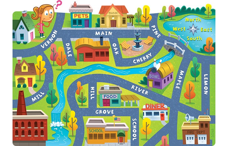
The bank is ____ of the pet store.
a)
East
b)
North
c)
West
d)
South
28.
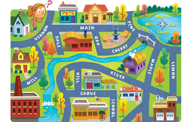
The fire dept. is ______ of the school.
a)
South
b)
East
c)
North
d)
West
29.
What IS NOT a part of most maps?
a)
Compass Rose
b)
Title
c)
Symbols/Key
d)
People
30.
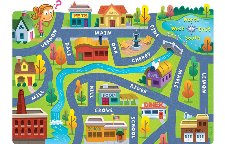
The bank is on what street?
a)
Main
b)
Maple
c)
Lemon
d)
River
31.
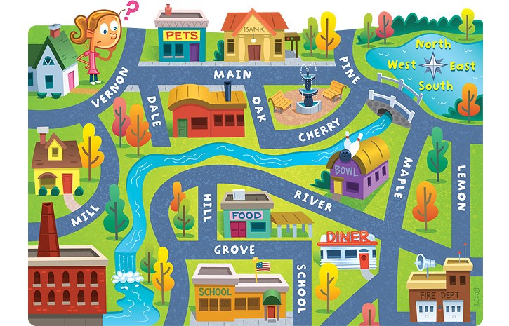
The school is ____ of the pet store.
a)
North
b)
South
c)
East
d)
West
32.
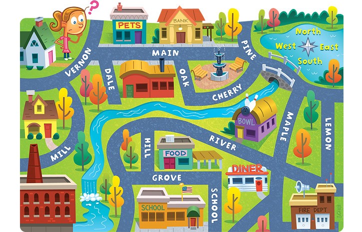
Lemon street runs _____________.
a)
East and West
b)
North and South
c)
South and West
d)
North and East
33.

Scale: 1in.=7ft. The actual width of the backyard is 49 ft, how wide is it in the drawing?
a)
14 in
b)
7 in
c)
42 in
d)
56 in
34.

From Denver to Chicago = 3 in. If the scale is 1 in = 300 miles, find the actual distance.
a)
300 miles
b)
1000 miles
c)
900 miles
d)
600 miles
35.
What is a map scale?
a)
a tool to measure distance
b)
a tool to tell direction
c)
a tool to start a fire
d)
a tool to build a house
36.

How many miles would 4 inches be equal to?
a)
2
b)
400
c)
4000
d)
4
37.

On this scale, what distance would 5 inches on the map represent?
a)
10 miles
b)
50 miles
c)
5 miles
d)
25 miles
38.
Identify the city that DOES NOT belong with the other Midwest Region cities
a)
Chicago
b)
Detroit
c)
Miami
39.
Which U.S. region has canyons (like the Grand Canyon) and deserts?
a)
Southwest
b)
Northeast
c)
Southeast
40.
Which region would you find states like Iowa, North Dakota, Ohio and Kansas?
a)
Northeast
b)
Southwest
c)
Midwest
41.
Texas, Oklahoma, New Mexico, Arizona are all states located in the same region
a)
Southwest
b)
Midwest
c)
Southeast
42.
Washington, D.C. is located in which region?
a)
Southeast
b)
Pacific
c)
Northeast
43.
Which region would you find the Statue of Liberty, located very close to New York City?
a)
Northeast
b)
Southeast
c)
Southwest
44.
States located in the Southeast include all of those listed EXCEPT
a)
Alabama
b)
West Virginia
c)
Montana
d)
Georgia
45.
Which state listed IS NOT part of the Pacific Region?
a)
California
b)
Oregon
c)
Washington
d)
Nevada
46.
The west region's vegetation is rich in ____.
a)
produce
b)
cacti
c)
peanuts
d)
yucca
47.
Wood, lumber, salt, and soil are all examples of natural resources from which region?
a)
Midwest
b)
Northeast
c)
West
d)
Southwest
100 %

