
 Worksheets
Geography
Total questions: 49
Worksheet time: 38mins
Name
Class
Date
1.
What are the largest areas of water on Earth?
a)
Rivers
b)
Lakes
c)
Oceans
d)
Ponds
2.
How many continents do we have on Earth?
a)
4
b)
5
c)
6
d)
7
3.
A _______ is a model of the Earth shaped like a sphere.
a)
map
b)
globe
c)
ball
d)
compass rose
4.
What are the areas at the top and bottom of the globe called?
a)
rings
b)
poles
c)
circles
d)
ends
5.
A __________________ is half of a sphere.
a)
semi-circle
b)
hemisphere
6.
The ________ divides the Earth into the northern and southern parts.
a)
Equator
b)
Prime Meridian
7.
The ________ divides the Earth into the eastern and western parts.
a)
Equator
b)
Prime Meridian
8.
A _______ is a flat model of the Earth.
a)
map
b)
globe
9.
What is it called when there is a change in shape and size of an object on a map?
a)
map scale
b)
cardinal directions
c)
distortion
d)
confusing
10.
North, South, East, and West are the ______________ directions.
a)
cardinal
b)
intermediate
11.
Northeast, Southwest, Northwest, and Southwest are the ______________ directions.
a)
cardinal
b)
intermediate
12.
Pictures on a map that represent something in the real world are called _____________.
a)
oceans
b)
continents
c)
symbols
d)
poles
13.
A map scale that uses a straight line like a number line or a rule.
a)
linear scale
b)
word scale
14.
A map scale that uses words.
a)
linear scale
b)
word scale
15.
How many oceans are there in the world?
a)
7
b)
6
c)
5
d)
4
16.
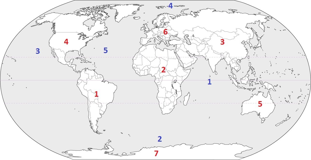
Which continent is located at #3?
a)
Australia
b)
Asia
c)
Europe
d)
South America
17.
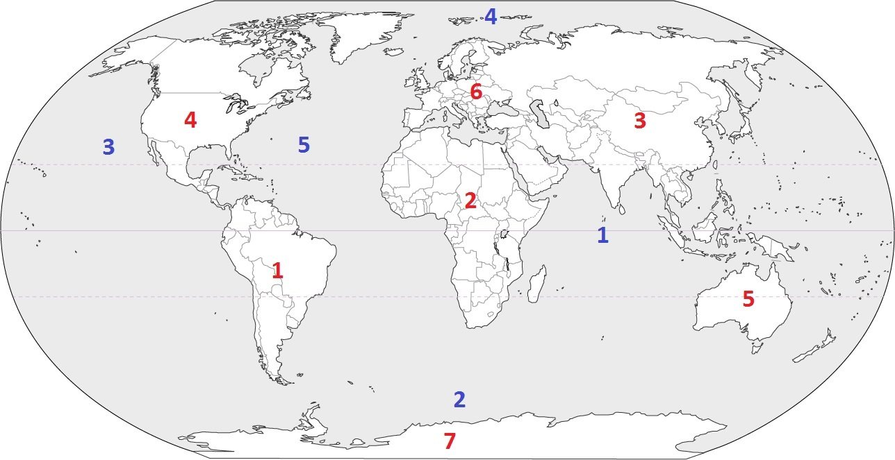
Which continent is located at #5?
a)
South America
b)
Asia
c)
Australia
d)
Antarctica
18.
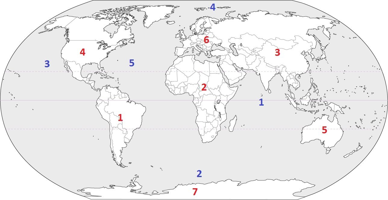
Which continent is located at #7?
a)
Asia
b)
Africa
c)
Australia
d)
Antarctica
19.
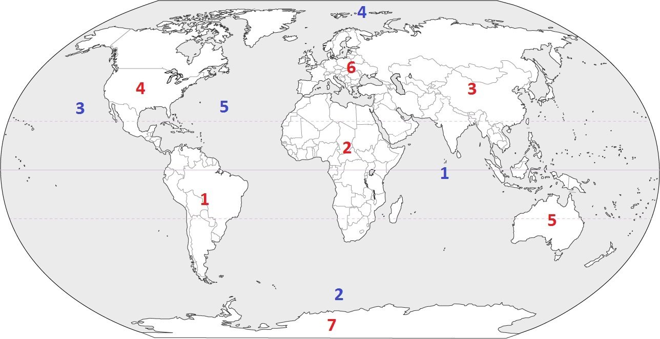
Which continent is located at #4?
a)
South America
b)
North America
c)
Europe
d)
Africa
20.
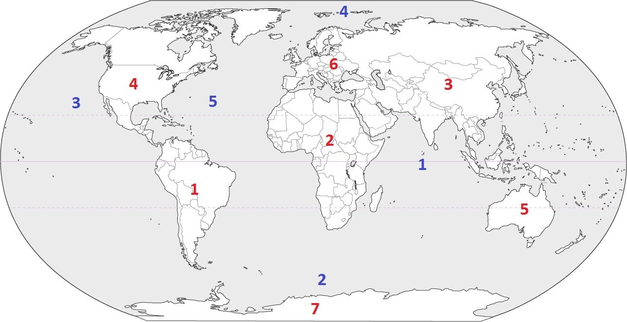
Which continent is located at #1?
a)
North America
b)
Antarctica
c)
South America
d)
Asia
21.
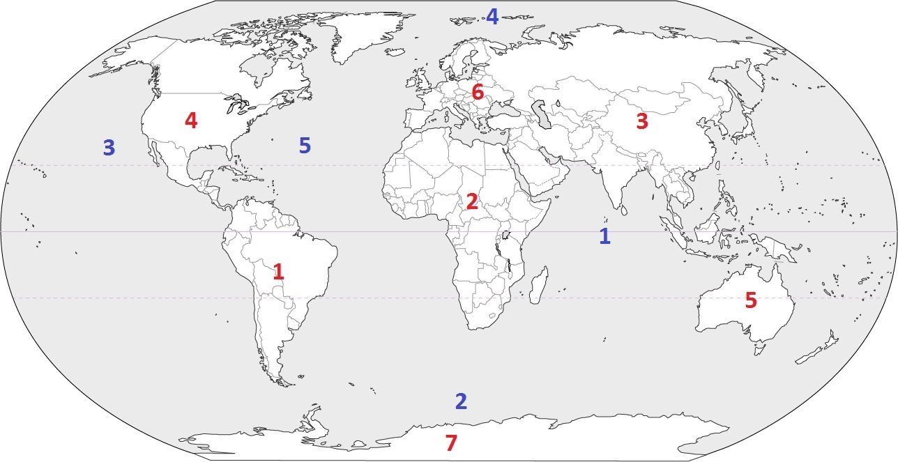
Which continent is located at #6?
a)
Asia
b)
Europe
c)
Africa
d)
Antarctica
22.
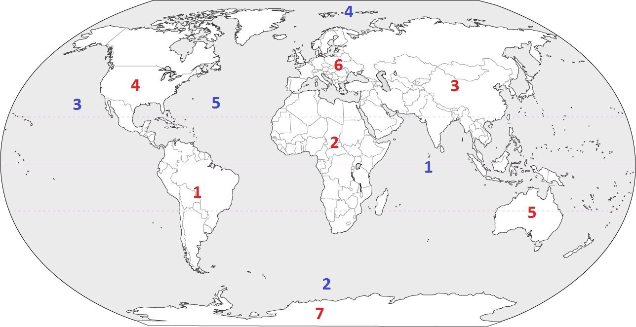
Which continent is located at #2?
a)
Africa
b)
South America
c)
Australia
d)
Europe
23.
Which is the largest continent in the world?
a)
Asia
b)
Africa
c)
North America
d)
Antarctica
24.

This continent is covered by large rainforests and is the wettest.
a)
North America
b)
Asia
c)
South America
d)
Africa
25.

This is the smallest continent, farthest away from the others where you may find koalas and kangaroos.
a)
Europe
b)
Africa
c)
South America
d)
Australia
26.

This continent contains major historic cities like Paris, London and Rome.
a)
Africa
b)
Europe
c)
Asia
d)
North America
27.
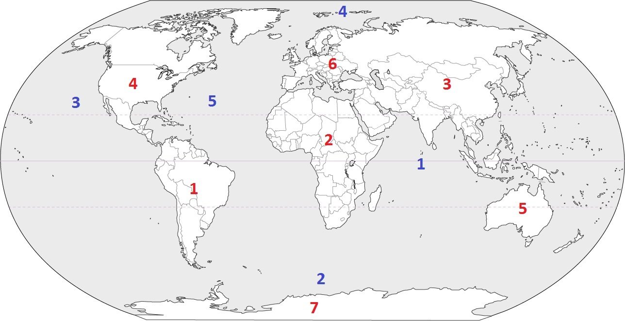
Identify the ocean at location #3
a)
Atlantic Ocean
b)
Arctic Ocean
c)
Pacific Ocean
d)
Indian Ocean
28.
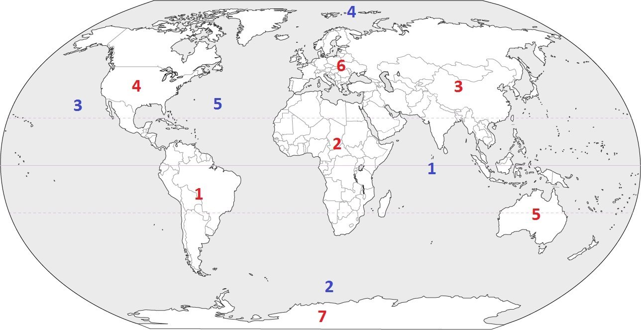
Identify the ocean at location #5
a)
Atlantic Ocean
b)
Southern Ocean
c)
Pacific Ocean
d)
Arctic Ocean
29.
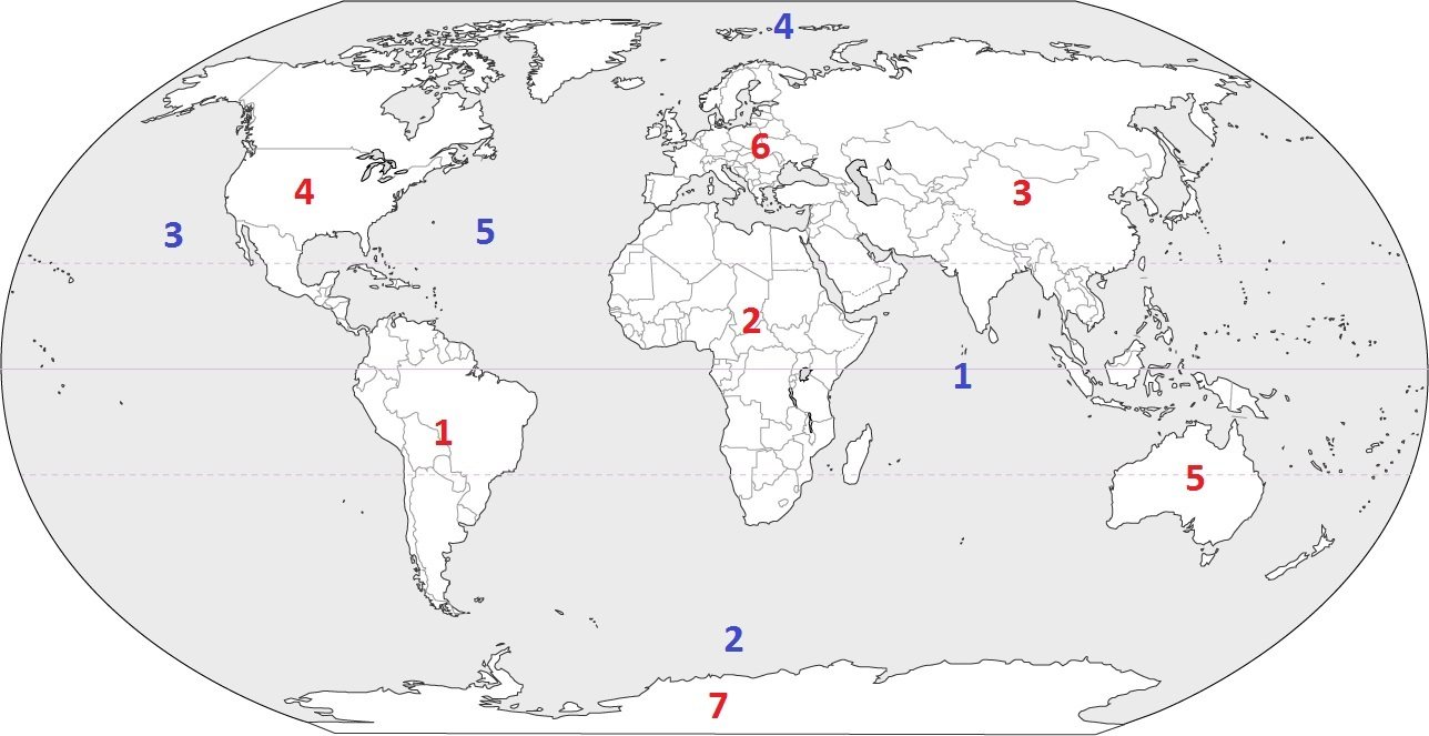
Identify the ocean at location #2
a)
Indian Ocean
b)
Pacific Ocean
c)
Southern Ocean
d)
Arctic Ocean
30.
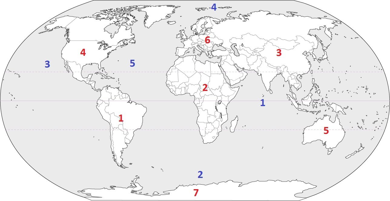
Identify the ocean at location #1
a)
Southern Ocean
b)
Arctic Ocean
c)
Atlantic Ocean
d)
Indian Ocean
31.
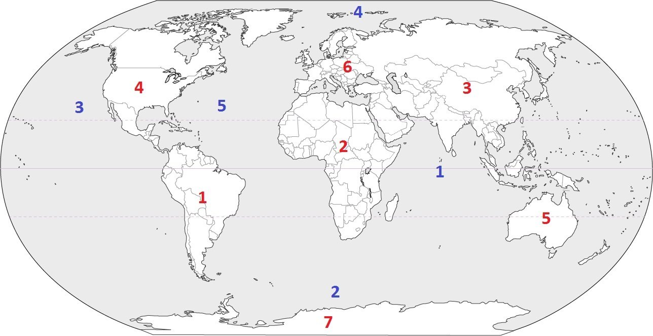
Identify the ocean at location #4
a)
Indian Ocean
b)
Pacific Ocean
c)
Arctic Ocean
d)
Atlantic Ocean
32.
Which type of map shows human features such as borders between states and countries?
a)
Political
b)
Physical
c)
Population
d)
Elevation
33.
Which type of map shows the height of the land?
a)
Political
b)
Physical
c)
Population
d)
Elevation
34.
Which type of map shows natural features, such as land forms and bodies of water?
a)
Political
b)
Physical
c)
Population
d)
Elevation
35.
Which type of map shows how many people live in an area?
a)
Political
b)
Physical
c)
Population
d)
Elevation
36.
Which answer is not a Cardinal
direction?
direction?
a)
North
b)
East
c)
Northeast
d)
South
37.
Which answer shows the tool we
use for cardinal and intermediate
directions?
use for cardinal and intermediate
directions?
a)
line of longitude
b)
compass rose
c)
map
d)
key
38.
Which answer is NOT an intermediate
direction?
direction?
a)
Westnorth
b)
Northeast
c)
Southwest
d)
Southeast
39.
The section of a map that explains the symbols for the map features; also called a legend
a)
Compass Rose
b)
Scale
c)
Map Key
d)
Title
40.

What is an explanatory list of symbols on a map called?
a)
cardinal directions
b)
compass rose
c)
map key
d)
map scale
41.

This part of a map is a way of showing the actual size compared to the size on the map.
a)
legend/key
b)
cardinal directions
c)
compass rose
d)
map scale
42.

This part of a map tells you the topic of a map, what the map is about.
a)
Map Title
b)
Map Key
c)
Map Grid
d)
Compass Rose
43.

This part of a map shows how far away a place is in real life.
a)
Map Grid
b)
Map Scale
c)
Map Title
d)
Map Key
44.

This part of a map helps you find the absolute location of places on a map.
a)
Map Title
b)
Coordinate Grid
c)
Compass Rose
d)
Map Scale
45.
What is an advantage of a map?
a)
Shaped like a sphere
b)
flat and easy to carry
c)
no distortion
46.
What is an advantage of a globe?
a)
flat and easy to carry
b)
same shape as earth
c)
shows lots of details
47.
Maps and globes are both _______ of the Earth.
a)
exact replicas
b)
illustrations
c)
models
d)
graphs
48.
Why have geographers names five oceans on Earth?
a)
Because there are five separate sections of water
b)
Because there were 5 geographers who discovered the oceans
c)
Because five was the favorite number of the geographers who discovered the oceans.
d)
Because geographers gave different names to sections of water separated by land.
49.
What continent is the United States a part of?
a)
Europe
b)
Australia
c)
South America
d)
North America
100 %

