
 Worksheets
Air Masses, Fronts, Storms, Weather Tools and Maps
Total questions: 40
Worksheet time: 29mins
Name
Class
Date
1.

According to the weather map seen here, we could expect weather conditions in El Paso to include
a)
cold temperatures, sunny skies.
b)
cold temperatures, cloudy, some precipitation.
c)
warm temperatures, sunny skies, and no rain.
d)
warm temperatures, increasing clouds, and showers.
2.

A cold front is approaching Minneapolis. What will happen to the air temperature?
a)
stay the same
b)
increase
c)
decrease
3.
What type of weather does an occluded front bring?
a)
Storms
b)
Light rain or snow
c)
Cold and Cloudy skies
d)
Several days of rain
4.

What front is moving through
Alabama and Georgia?
Alabama and Georgia?
a)
Warm
b)
Occluded
c)
Stationary
d)
Cold
5.

What direction is the cold front moving?
a)
Northwest
b)
Southeast
c)
Northeast
d)
Southwest
6.

Which city can expect to see an increase in temperatures over the next 24 hours?
a)
Billings, Montana
b)
Atlanta, Georgia
c)
Minneapolis, Minnesota
d)
Miami, Florida
7.

After a cold front passes through, what type of weather will there be?
a)
Rainy or stormy, and cloudy
b)
Clear, dry, and sunny
8.

Air masses are classified by which 2 characteristics?
a)
temperature and air pressure
b)
air pressure and wind speed
c)
air pressure and humidity
d)
temperature and humidity
9.
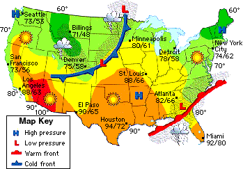
A high pressure system is located north of New York City. What type of weather will be experienced there?
a)
clear, sunny skies
b)
cloudy and rainy
10.
A low pressure system is located over Georgia. What type of weather will they have?
a)
clear, sunny skies
b)
cloudy and rainy
11.
A scientist who measures and predicts weather conditions is known as
a)
an astronomer
b)
a geologist
c)
a meterologist
d)
a weatherologist
12.
A warm front moving into an area can bring this type of weather...
a)
Warmer Temperatures, Clear Skies
b)
Colder Temperatures, Clear Skies
c)
Warmer Temperatures, Clouds, and steady precipitation
d)
Colder Temperatures, Clouds, and Precipitation
13.
A cold front moving into an area can bring this type of weather...
a)
Warmer Temperatures, Clear Skies
b)
Colder Temperatures, Clear Skies
c)
Warmer Temperatures, Clouds
d)
Colder Temperatures, Clouds, and Precipitation
14.
Air pressure is greatest:
a)
closer to Earth
b)
farther from Earth
15.

The amount of water vapor present in the air is called ________________.
a)
weather
b)
humidity
c)
air mass
d)
dew point
16.

What direction is the warm front moving?
a)
Northeast
b)
Northwest
c)
Southeast
d)
Southwest
17.
What front is moving through
Alabama and Georgia?
Alabama and Georgia?
a)
Warm
b)
Occluded
c)
Stationary
d)
Cold
18.

A United States weather map is provided.
Based on the information provided in the weather map, which city shown is most likely experiencing the cloudiest skies and most precipitation?
Based on the information provided in the weather map, which city shown is most likely experiencing the cloudiest skies and most precipitation?
a)
Baltimore
b)
Jacksonville
c)
Portland
d)
Rapid City
19.

Which weather front are severe storms most likely to develop?
a)
warm front
b)
stationary front
c)
cold front
d)
occluded front
20.

Name the front.
a)
cold front
b)
occluded front
c)
stationary front
d)
warm front
21.

Identify the front shown in the diagram.
a)
warm front
b)
cold front
c)
stationary front
d)
occluded front
22.

What does the H and L stand for on the weather map?
a)
high and low pressure systems
b)
heat and land regions
c)
heavy and local winds
d)
high and long distances
23.

The weather data for Columbia shows the barometric reading is rising. Which is the best forecast for the weather in the Columbia area?
a)
Clearer, drier weather
b)
stormy weather
c)
falling temperatures
d)
no change at all
24.
If the relative humidity is at 99%, it is likely to rain.
a)
True
b)
False
25.
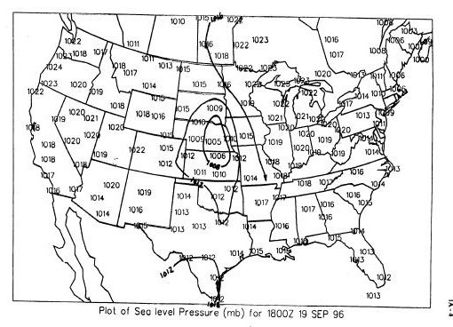
What is the lowest pressure value?
a)
1006
b)
1008
c)
1012
d)
1024
26.
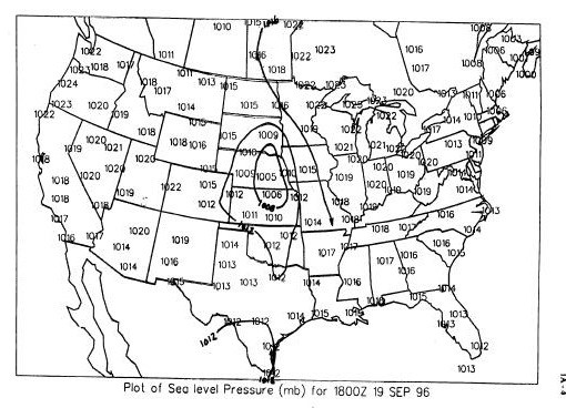
What is the highest pressure value?
a)
1006
b)
1008
c)
1012
d)
1024
27.
What are lines on a weather map connecting points of equal pressure?
a)
Isotherms
b)
Isoclines
c)
Isobars
d)
Isochrons
28.
What are lines on a weather map connecting points of equal temperature?
a)
Isotherms
b)
Isoclines
c)
Isobars
d)
Isochrons
29.

A violently rotating column of air called a _____ when it comes in contact with the ground.
a)
hurrican
b)
tornado
c)
trade wind
d)
local wind
30.

This weather tool is used to measure...
a)
Temperature
b)
Rainfall
c)
Wind Speed
d)
Humidity
31.

This weather tool is used to determine...
a)
Temperature
b)
Wind Vain
c)
Wind Direction
d)
Rainfall
32.
This type of severe weather causes heavy flooding, high winds, and storm surge.
a)
Tornado
b)
Hurricane
c)
Blizzard
d)
Thunderstorm
33.

What type of weather would you predict for Columbia, SC based on this weather map?
a)
Cooler and potential for storms
b)
Warm and clear
c)
Consistently hot and sunny
d)
Record highs
34.
_____ climate is described as hot with a little rain, and is located in low latitudes.
a)
Moderate
b)
Tropical
c)
Continental
d)
Dry
35.
_____ climate is described as cold all year long and located in high latitudes.
a)
Polar
b)
Continental
c)
Dry
d)
Highland
36.

An instrument that measures air pressure
a)
thermometer
b)
barometer
c)
rain guage
d)
wind sock
37.
An instrument used to measure how hot or cold something is
a)
barometer
b)
thermometer
c)
wind sock
d)
rain guage
38.

An instrument used to measure the amount of rainfall
a)
barometer
b)
thermometer
c)
rain guage
d)
wind sock
39.

Jay and Jeff were responsible for recording the class weather data each day in March. This is how the wind sock looked when they went out this morning. What direction is the wind blowing from?
a)
north
b)
south
c)
east
d)
west
40.

Why is a low pressure area, like the one in the map, created along a cold front?
a)
The cold air drops the temperature, creating a low pressure area.
b)
The cold air pushes away the warm air, creating a low pressure area.
c)
The dense, cold air brings rain with it, creating a low pressure area.
d)
The dense, cold air pushes the warm air up, creating a low pressure area.
100 %

