
 Worksheets
Africa Map Review
Total questions: 20
Worksheet time: 12mins
Name
Class
Date
1.
Name the biggest desert in Africa
a)
Kalahari
b)
Sahara
c)
Congo
d)
Sahel
2.
Name the tallest Peak in Africa
a)
Mt. Atlas
b)
Mt. Congo
c)
Ethiopian highlands
d)
Mt.Kilimanjaro
3.
What are the two deserts in Africa
a)
Nafud and Arabian
b)
Death Valley and Sahara
c)
Sahara and Kalahari
d)
Kalahari and Death Valley
4.
Name the mountains that are in North western Africa
a)
Ethiopian Highlands
b)
Rockies
c)
Alps
d)
Atlas
5.
Name the mountains located in the east of Africa in what is known as the "horn of Africa"
a)
Ethiopian Highlands
b)
Atlas Mountains
c)
Alps Mountains
d)
Rocky Mountain
6.
How has the history of Sub-Saharan Africa contributed to political instability in some nations of the region?
a)
The devastation of the Second World War has left some nations struggling to recover.
b)
The end of foreign aid to the region is leaving many without proper food and medicine.
c)
The end of European colonization left some nations struggling to form an effective governments.
d)
The migration of the Bantu-speaking people across national boundaries has caused a clash of cultures.
7.
What is the study of how societies use scarce resources to produce valuable commodities and distribute them among different people?
a)
Geography
b)
History
c)
Economics
d)
Political
8.
What is the characteristics and knowledge of a particular group of people, defined by everything from language, religion, cuisine, social habits, music and arts.
a)
History
b)
Culture
c)
Language
d)
Religion
9.
A map that shows the location of landforms and features like rivers, lakes, ocean, mountains, valleys, deserts and different land elevations.
a)
political
b)
physical
c)
special purpose
d)
GPS
10.
A maps designed to show governmental boundaries of countries and states. They can also indicate the location of major cities, and they usually include significant bodies of water.
a)
physical
b)
political
c)
special purpose
d)
GPS
11.
Which geographic factor is MOST responsible for the prosperous mining operations in South Africa?
a)
mountainous countryside
b)
plentiful natural resources
c)
semi-arid climate
d)
ocean trade routes
12.

a)
Mali
b)
Senegal
c)
Uganda
d)
Botswana
13.
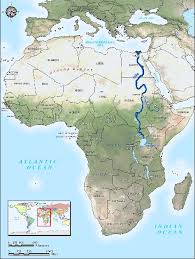
What river is highlighted? This is the longest river on earth from North to South.
a)
Congo
b)
Zambezi
c)
Nile
d)
Amazon
14.
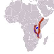
What geographic feature is highlighted? It is a ridge & plate boundary with lots of volcanic activity beneath its surface. Millions of years from now, it will split the continent in half.
a)
Sahel
b)
Transition Zone
c)
Ring of Fire
d)
Great Rift Valley
15.
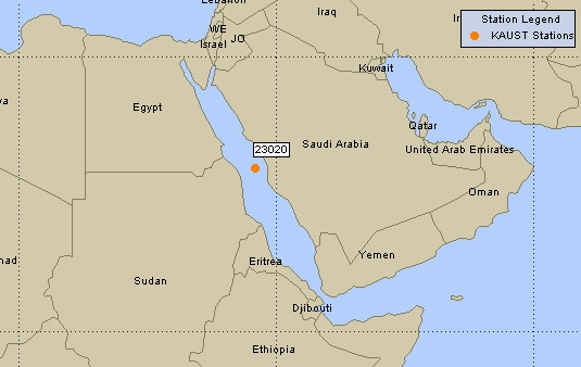
What body of water is shown on the map? It is narrow and separates Africa from the Arabian peninsula (Asia).
a)
Straits of Comoros
b)
Red Sea
c)
Dead Sea
d)
Mediterranean Sea
16.

What country is highlighted? It has the largest economy and population in Africa.
a)
Ethiopia
b)
Nigeria
c)
South Africa
d)
Ghana
17.

What country is highlighted? Its capital is Addis Ababa. The majority of the population is Orthodox Christian, and it is one of two countries on earth (the other being Russia) to have never been occupied by another power.
a)
Ethiopia
b)
Somalia
c)
Libya
d)
Mali
18.

What country is highlighted? It is the 2nd largest country in Africa in terms of land area (after Algeria). It has been in a state of civil war since the 90s.
a)
Angola
b)
Democratic Republic of the Congo
c)
Senegal
d)
Uganda
19.
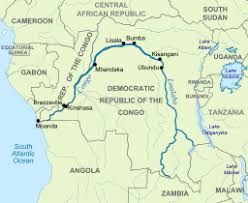
What river is highlighted? It flows through heavily forested regions in the center of the African continent.
a)
Congo
b)
Zambezi
c)
Kasai
d)
Nile
20.

What is the main geographic feature of Central Africa?
a)
The Congo River Basin & rainforest
b)
Nile River Valley
c)
Kalahari Desert
d)
Sahel region
100 %

