
 Worksheets
International and Internal Boundaries
Total questions: 29
Worksheet time: 20mins
Name
Class
Date
1.

Barriers like the Berlin Wall (pictured) and the Great Wall of China are often referred to as _________ borders?
a)
Relic
b)
Antacedent
c)
Geometric
d)
Superimposed
2.

What natural boundary serves as the border between Mexico and Texas.
a)
The Rio Grande
b)
The Nueces
c)
Arkansas River
d)
The Rocky Mountains
3.
All of the following can serve as natural boundaries except
a)
Latitude Lines
b)
Rivers
c)
Mountains
d)
Lakes
4.
Human made boundaries can be created using lines of latitude and longitude
a)
True
b)
False
5.
Geometric Boundaries are made of straight lines created by nature?
a)
True
b)
false
6.
West of the Great Lakes the border between US and Canada is
a)
geometric
b)
physical
c)
river
d)
stateless
7.
redistricting for the benefit of one party over another
a)
corruption
b)
gerrymandering
c)
political parties
d)
borders
8.
Invisible line that marks the extent of a state’s territory
a)
Boundary
b)
Colony
c)
Prorupted State
d)
State
9.
Process of redrawing legislative boundaries for the purpose of benefiting the party in power
a)
Compact state
b)
Gerrymandering
c)
Boundary
d)
Unitary state
10.

What do the maps below represent?
a)
reapportionament
b)
US census
c)
splitting
d)
gerrymandering
11.
Boundaries set by ethnic differences, especially those based on language and religion.
a)
Physical boundaries
b)
Economic Boundaries
c)
Political boundaries
d)
Cultural Boundaries
12.
Boundaries established by rivers, oceans, deserts, mountains, etc.
a)
Political boundaries
b)
Physical boundaries
c)
Cultural boundaries
d)
Geographic boundaries
13.
Which type of boundary would use lines of latitude and longitude?
a)
Antecedent
b)
Subsequent
c)
Geometric
d)
Relic
14.

This image shows what type of boundary?
a)
Geometric Boundary
b)
Physical Boundary
c)
Cultural Boundary
d)
Linear Boundary
15.

This image shows what type of boundary?
a)
Geometric Boundary
b)
Physical Boundary
c)
Cultural Boundary
d)
Linear Boundary
16.
Who was the developer of the Heartland Theory
a)
Nicolas Spykman
b)
Friedrich Ratzel
c)
Halford Mackinder
d)
James Monroe
17.

Which characteristic do all the nations seen here share?
a)
All are compact
b)
All are landlocked
c)
All are federal states
d)
All are members of OPEC
18.

The Himalayas serve as a natural _________ boundary separating China from South Asia
a)
Mountain
b)
Ocean
c)
River
d)
Geometric
19.

The straight border lines of the western states following lines of latitude and longitude.
a)
Physical Borders
b)
Geometric Borders
c)
Man-Made structural borders
d)
Water borders
20.
A boundary identified by physical objects placed on the landscape (signs, fences or walls)?
a)
Demarcated
b)
Relic
c)
Subsquent
d)
Anticedent
21.
A region not fully integrated into a national state that is often marginal or undeveloped is a called a
a)
stateless nation
b)
frontier
c)
core
d)
functional
22.
Which of the following is an example of a nation seeking its own territory?
a)
Mexicans
b)
Palestinians
c)
English
d)
Texas
23.
A Shatterbelt is defined as an area of instability between two regions. Which would be an example of this concept?
a)
Eastern Europe
b)
Western Europe
c)
China
d)
North America
24.
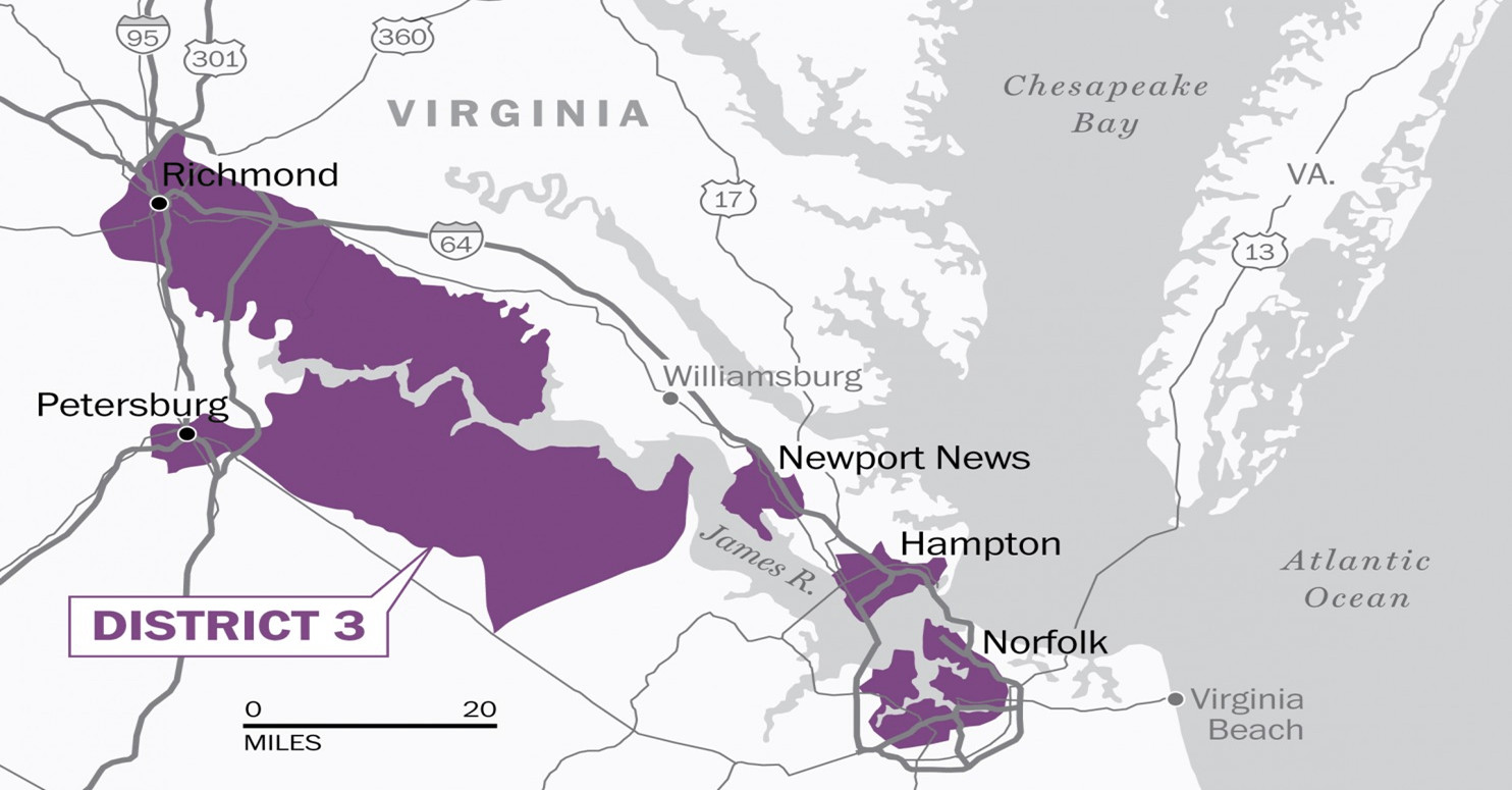
The map above illustrates what concept designed to give political advantage to a particular group?
a)
devolution
b)
political enclave
c)
gerrymandering
d)
cultural landscape
25.

Examine the image seen here. Which theory created in the early 20th century advocated that any political power based in the center of Eurasia could gain enough strength to dominate the world?
a)
Unilateral Theory
b)
Mackinder's Heartland Theory
c)
Wallerstein's World Systems Theory
d)
Huntington's Class of Civilizations Thesis
26.
The Berlin Wall is an example of a ____________ boundary
a)
religious
b)
antecedent
c)
relic
d)
geometric
27.
The study of human political organization of the Earth
a)
Cultural Geography
b)
Ethnography
c)
Deography
d)
Political Geography
28.
A state or group of states that exists within a sphere of competition between larger states and is often culturally, economically, and politically fragmented and splintered.
a)
Frontier
b)
Satellite States
c)
Shatterbelt
d)
Buffer State
29.
A region where boundaries are very thinly or weakly developed, zones where territoriality is unclear and not well established.
a)
Frontier
b)
Shatterbelt
c)
Buffer State
d)
Satellite State
100 %

