
 Worksheets
U1 - Geography Basics and the Five Themes
Total questions: 106
Worksheet time: 1hrs 7mins
Name
Class
Date
1.
An imaginary line or meridian measuring east or west of the prime meridian.
a)
longitude
b)
langoustine
c)
latitude
d)
geogrpahy
2.
On which two hemispheres do we live?
a)
Northern and Eastern
b)
Eastern and Southern
c)
Western and Southern
d)
Northern and Western
3.
Which imaginary line divides the Earth into the northern and southern hemispheres?
a)
Prime Meridian
b)
Equator
c)
Axis
d)
North Pole
4.
What does "geo" mean?
a)
earth
b)
water
c)
stone
d)
None of these
5.
One characteristic of a Physical Map is...
a)
Shows the different climates in the world
b)
show important natural, physical features, such as mountains, elevations, rivers, vegetation, forests and lakes.
c)
show how people have divided up the earth's surface
d)
show how many people live in an area
6.
A large area of land with common features that sets it apart from other areas.
a)
regal
b)
region
c)
reggae
d)
reggie
7.
A __________ tells you what each symbol on the map stands for.
a)
legal
b)
lobster
c)
legend
d)
langoustine
8.
The study of the Earth and the way people live and use it.
a)
Geology
b)
Genome
c)
Geography
d)
Geode
9.
A shape on the Earth's surface, such as a mountain or hill
a)
landform
b)
longitude
c)
latitude
d)
geography
10.
Which part of the map show the directions?
a)
Map Title
b)
Compass Rose
c)
Map key or legend
d)
Grid Lines
11.
Which of the following is NOT a cardinal direction?
a)
North
b)
West
c)
Southeast
d)
East
12.
A Map key, scale and title does what?
a)
get into somewhere
b)
Helps you to read and understand a map
c)
know how much you weigh
d)
get out of somewhere
13.
What does a cartographer do?
a)
drives a cart
b)
makes carts
c)
makes maps
d)
maps carts
14.
What kind of tool would a Cartographer from the past use?
a)
Satellite Images
b)
Globes
c)
Aerial Photographs
d)
GIS
15.
What kind of map would you use to find out what countries in the world are overpopulated?
a)
Population Density Map
b)
Political Map
c)
Economic/Product Map
d)
Climate Map
16.
What kind of map would you use to find the bodies of water in India?
a)
Political
b)
Physical
c)
Population
d)
Topographical
17.
Imaginary lines going horizontally (-----) around the Earth are called ________ ____ ________________.
a)
lines of longitude
b)
lines of latitude
c)
lines of the Earth
d)
prime meridian lines
18.
The purpose of a compass rose it to ___________________.
a)
identify directions
b)
identify size
c)
identify colors
d)
to smell pretty
19.
How do you know what the map is all about?
a)
Read the title
b)
Look at the map key
c)
Look at the compass rose
20.
The lines on the globe that appear horizontal on your maps and go North or South of the equator are line of ___________
a)
latitude
b)
longitude
c)
prime meridian
d)
meridians
21.
Lines that appear vertical on your maps and show East of West of the Prime Meridian are known as lines of _________
a)
contour intervals
b)
latitude
c)
longitude
d)
parallels
22.
The 0 degree line of latitude is the ___________.
a)
Equator
b)
Prime Meridian
c)
International Date Line
d)
Contour line
23.
The line of longitude 180 East or 180 West of the Prime Meridian is known as the _____________ ____ ____.
a)
Equator
b)
Latitude
c)
International Date Line
d)
International Hot Line
24.
Another name for lines of latitude are ___________.
a)
parallels
b)
meridians
c)
contour lines
d)
intervals
25.
A __________ shows relationship between distance on map to distance on Earth
a)
legend
b)
compass
c)
direction
d)
scale
26.
The 0 degree mark of longitude is known as the ___________ ______________ measure from Greenwich England.
a)
Equator
b)
Prime Meridian
c)
International Date Line
d)
Contour Line
27.
Another name for lines of longitude is _______________.
a)
parallels
b)
meridians
c)
relief
d)
contour lines
28.

What is the name of the line at zero degrees longitude?
a)
Equator
b)
Prime Meridian
c)
North Pole
d)
South Pole
29.

What is the name of this line at 0 degrees latitude?
a)
Prime Meridian
b)
Equator
c)
North Pole
d)
South Pole
30.
Latitude lines on a globe are labeled-
a)
north & south
b)
east & west
c)
north & east
d)
south & west
31.

What is the approximate location of letter B?
a)
80oN, 0o
b)
0o, 80oW
c)
80oS, 0o
d)
0o, 80oE
32.

What is the approximate location of G?
a)
100oW, 40oN
b)
40oN, 100oW
c)
40oS, 100oW
d)
40oN, 100oE
33.

Which of the following letter is at approximately 60 degrees S, 40 degrees W?
a)
A
b)
D
c)
E
d)
H
34.

What is the absolute location for G?
a)
45oS, 54oE
b)
30oS, 150oW
c)
150oS, 30oE
d)
30oS, 150oE
35.

Which letter would you find at 15oS, 60oW?
a)
A
b)
C
c)
L
d)
H
36.

a)
The map show the lines of longitude.
b)
The map shows the lines of latitude.
37.

a)
The map shows lines of longitude.
b)
The map shows lines of latitude.
38.

Which city is located at 38 degrees north and 120 degrees west?
a)
San Fransisco
b)
New York
c)
New Orleans
d)
London
39.
Which continent is located completely north of the Equator and west of the Prime Meridian?
a)
Asia
b)
Europe
c)
North America
d)
South America
40.
Which continent is completely south of the Equator and east of the Prime Meridian?
a)
Antartica
b)
South America
c)
North America
d)
Australia
41.
In the coordinate pair which line is always labeled first?
a)
Latitude
b)
Longitude
42.
Lines of Latitude and Longitude help establish
a)
Region
b)
Absolute Location
c)
Relative Location
d)
Place
43.
Which themes describes how humans change a particular place?
a)
Location
b)
Place
c)
Human-Environment Interaction
d)
Movement
44.
Which theme of Geography does Absolute and Relative Location belong to?
a)
Place
b)
Location
c)
Region
d)
Movement
45.
The Appalachian Mountains are physcial characteric of NC. Which theme does this represent?
a)
Place
b)
Location
c)
Movement
d)
Region
46.
When we describe a place by saying it has a beautiful lake and mountains, we are describing its
a)
Physical Characteristics
b)
Human Characteristics
47.
Which theme of geography am I referring to when I say: "North Carolina is located to the east of Tennessee"?
a)
Place
b)
Region
c)
Movement
d)
Location
48.
True or False: Human-Environment Interaction is the theme that focuses on the way a place physically looks.
a)
True
b)
False
49.
The way that goods, people, and information move in and out of a place is an example of the theme of:
a)
Human-Environment Interaction
b)
Place
c)
Movement
d)
Location
50.
True or False: Stating “The island is 64°W 16°N" is an example of absolute location.
a)
True
b)
False
51.
What is movement?
a)
Tells us how people, goods, recourses, and ideas move from one place to another
b)
Tells us what makes an area special and what makes it different from every other area
c)
Tells us ways in which the places in an area are alike.
52.
What is location?
a)
Tells us where people and places are
b)
Tells us what makes an area special and what makes it different from every other area.
c)
Tells how people, goods, resources, and ideas move from one place to another.
53.
Latitude lines run
a)
East/West
b)
North/South
54.
Longitude lines run _________.
a)
East/West
b)
North South
55.
Cutting down trees to build houses is an example of which?
a)
Location
b)
Place
c)
Human-Environment Interaction
d)
Movement
56.
People leaving their homes in Syria and travelling to Turkey to avoid ISIS is an example of which?
a)
Human-Environment Interaction
b)
Movement
c)
Absolute Location
d)
Relative Location
57.
The Middle East is an example of which?
a)
Human-Environment Interaction
b)
Relative Location
c)
Movement
d)
Region
58.
The fact that Africa is south of Europe is an example of which?
a)
Movement
b)
Absolute Location
c)
Relative Location
d)
Place
59.

What is the Relative Location of the Gulf of Mexico?
a)
west of Houston
b)
85 degrees W by 27 degrees N
c)
85 degrees N by 27 degrees W
d)
west of Miami
60.
What are the 5 Themes of Geography?
a)
Region, Human-Environment Interaction, Location, Climate, and Place
b)
Region, Human-Environment Interaction, Movement, Place, and Location
c)
Place, Movement, Location, Region, and Human-Alien Interactions
d)
Absolute Location, Relative Location, Climate, Vegetation, and Movement
61.
What is the acronym that can be used to "help" you remember the 5 Themes of Geography?
a)
MR. HELP
b)
MS. HELP
c)
MR. HIP
d)
MRS. HEL
62.
The Midwest is known for growing grains is an example of which theme?
a)
Region
b)
Place
c)
Location
d)
Human-Environment Interaction
63.
The White House is located at 1600 W. Pennsylvania Ave is which theme?
a)
Place
b)
Relative Location
c)
Absolute Location
d)
Movement
64.
An area that can be defined by human or physical characteristics?
a)
Region
b)
Location
c)
Place
d)
Environment
65.
A large number of people from New Orleans, Louisiana moved north after Hurricane Katrina is which theme?
a)
Place
b)
Movement
c)
Region
d)
Location
66.
The mall is about 10 minutes East of the school is an example of which theme?
a)
Absolute Location
b)
Relative Location
c)
Region
d)
Place
67.
A newspaper, cell phone, and CNN News are all examples of....
a)
Region
b)
Relative Location
c)
Movement
d)
Human-Environment Interaction
68.
A group of places that have a common feature is which theme?
a)
Location
b)
Region
c)
Movement
d)
Continent
69.
Which is an example of a human characteristic?
a)
Tree
b)
Boat
c)
Mountain
d)
Lake
70.
Which is NOT a type of human-environment interaction?
a)
Adapt
b)
Destroy
c)
Modify
d)
Depend
71.
If there were no trees in your area and you used sod (grass and dirt) to build a home, what type of interaction is that?
a)
Modify
b)
Adapt
c)
Depend
72.
The theme that asks the question "Where is it?"
a)
Place
b)
Region
c)
Movement
d)
Location
73.
What is a positive human-environment interaction?
a)
Cutting down trees
b)
Recycling
c)
Pollution
d)
Littering
74.
What are the two types of location?
a)
Absolute and Migration
b)
Longitude and Region
c)
Relative and Latitude
d)
Absolute and Relative
75.
Communicating through text message is which theme?
a)
Place
b)
Region
c)
Relative Location
d)
Movement
76.

River
a)
Physical Geography
b)
Human Geography
c)
Environmental Geography
77.

Volcano
a)
Physical Geography
b)
Human Geography
c)
Environmental Geography
78.

City
a)
Physical Geography
b)
Human Geography
c)
Environmental Geography
79.

Pollution
a)
Physical Geography
b)
Human Geography
c)
Environmental Geography
80.

Earthquake
a)
Physical Geography
b)
Human Geography
c)
Environmental Geography
81.

Climate Change
a)
Physical Geography
b)
Human Geography
c)
Environmental Geography
82.

Culture
a)
Physical Geography
b)
Human Geography
c)
Environmental Geography
83.

Flags
a)
Physical Geography
b)
Human Geography
c)
Environmental Geography
84.

Mountains
a)
Physical Geography
b)
Human Geography
c)
Environmental Geography
85.

Oil Spill
a)
Physical Geography
b)
Human Geography
c)
Environmental Geography
86.

Deforestation
a)
Physical Geography
b)
Human Geography
c)
Environmental Geography
87.

Coast
a)
Physical Geography
b)
Human Geography
c)
Environmental Geography
88.

Weather
a)
Physical Geography
b)
Human Geography
c)
Environmental Geography
89.

Industry
a)
Physical Geography
b)
Human Geography
c)
Environmental Geography
90.
Which of the following is not a tool of a geographer?
a)
Horse
b)
GPS
c)
Computer
d)
Map
91.

This map is an example of a . . .
a)
Population Map
b)
Thematic Map
c)
Climate Map
d)
Land Use and Resources Map
92.

This map is an example of a . . .
a)
Political Map
b)
Physical Map
c)
Population Map
d)
Thematic Map
93.

This map is an example of a . . .
a)
Political Map
b)
Land Use Map
c)
Physical Map
d)
Thematic Map
94.
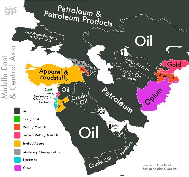
This map is an example of a . . .
a)
Political Map
b)
Physical map
c)
Land Use and Resource Map
d)
Historical Map
95.

This map is an example of a . . .
a)
Topographic Map
b)
Physical Map
c)
Population Map
d)
Historical Map
96.

This map is an example of a . . .
a)
Physical Map
b)
Thematic Map
c)
Population Map
d)
Climate Map
97.

This map is an example of a . . .
a)
Physical Map
b)
Topographic Map
c)
Political map
d)
Land Use and Resource Map
98.

What type of map shows borders between states and countries?
a)
Road Map
b)
Physical Map
c)
Time Zone Map
d)
Political Map
99.
What word is used for understanding how location, scale, and patterns of geography on the Earth are spaced out?
a)
Spatial
b)
Distortion
c)
Mercator Map Scale
d)
Conic Projection
100.
This is another word for a person's way of looking at something.
a)
Perspective
b)
Distortion
c)
Cartographer
d)
Map Projection
101.
The Study of Earth's natural landscapes and physical systems
a)
Cartography
b)
Climatology
c)
Physical Geography
d)
Meteorlogy
102.
Open Land Usually Used for Farming
a)
Urban
b)
Suburb
c)
Rural
d)
Subregion
103.
Tracking Earth's Larger Atmospheric Systems Over a Long Period of Time
a)
Cartography
b)
Climatology
c)
Meteorology
d)
Diffusion
104.
A Geographer's Point of View: Where Something is and Why is it There
a)
Spatial Perspective
b)
Cartography
c)
Meteorology
d)
Human Geography
105.
City Like...
a)
Rural
b)
Suburban
c)
Urban
d)
Diffusion
106.
The Study of People Past or Present is...
a)
Geography
b)
Meteorology
c)
Human Geography
d)
Diffusion
100 %

