
 Worksheets
Plate Tectonics Review
Total questions: 30
Worksheet time: 16mins

What part of this Earth diagram is part C?
the core
the crust
the mantle
the atmosphere

Earthquake epicenters were mapped for 45 years. The black dots marking the epicenters also represent what feature of the Earth?
hot spots
rift zones
plate boundaries
sea floor spreading
This causes plate movement, earthquakes and volcanic activity.
Conduction
Convection
Ocean
Radiation
-convection of the mantle
-magma injection at spreading boundaries
-gravity pulling the plates downward at subduction zones
These are three theorized causes of
glacial melting
changing of the climate
high and low ocean tide
movement of tectonic plates

Based on the illustration above what can you conclude about the density of the Earth's layers?
the density of the layers decreases as pressure increases
the density of the layers increases as temperature decreases
the density increases in layers that are closer to the core
the density increases in layers that are closer to the surface
Which waves cannot travel through the liquid outer core?
L waves
P waves
S waves
R waves
Which of these pieces of evidence did NOT help in the development of the theory of plate tectonics?
outlines of the continents look like puzzle pieces
fossils on continents separated by great distances
earthquakes and volcanoes occur on boundary lines
no mountains are increasing in size

What is the main method of heat transfer from the core to the crust?
conduction
convection
insulation
radiation

The Earth has a magnetic field that originates from the outer core. The outer core is composed of
plasma
iron and nickel
nickel and lead
lead and mercury
There are three types of plate boundaries. Which is NOT a type of plate boundary?
convergent
divergent
thrust
transform
The movement of the tectonic plates is caused by
convection current in Earth's mantle
gravity of the iron-nickel core
the rotation of the Earth
the Moho discontinuity
Fossils of an extinct dinosaur are found on the continents of South America and Africa. This dinosaur could not swim or fly so how is this possible?
The continents were once connected
A land bridge once connected the continents
The same type of animals evolved on both continents
Prehistoric man transported the dinosaur between the continents

The map above would be useful in predicting the location of future
droughts
earthquakes
hurricanes
tornadoes
What was Pangaea? When did it break apart?
a large ocean basin that opened in the Triassic and closed in the Paleocene
the supercontinent that formed in the late Paleozoic and broke apart in the Mesozoic
a huge mountain range formed when Africa pushed into Europe in Eocene time
a large Precambrian shield of Africa and South America that broke apart in the Proterozoic
The plate near Hawaii grows at a rate of 11 cm/year. How many centimeters will the plate grow in 2 years?
2 cm
11 cm
22 cm
33 cm

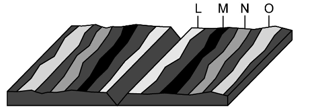
What type of plate boundary is shown in the illustration?
mantle boundary
transform boundary
divergent boundary
convergent boundary
Earth's surface is not solid but divided into
several oceanic plates
seven continental plates
continental and crustal plates
continental and oceanic plates
In the rocks of Mt Everest you can find sea life fossils. What does this evidence support?
the theory of plate tectonics
the big bang
natural selection
survival of the fittest
The 2004 tsunami was caused by a shift in two plates that pushed one section of seafloor under another. What type of boundary is this?
divergent
transform
convergent
metamorphic
Hawaii is located over a tectonic plate. Because of this, Hawaii is most likely to experience
erosion
tornadoes
hurricanes
volcanic eruptions
A core sample was taken from the center of a small town. The bottom of the sample showed rock formed from a lava flow. What does that suggest about the town?
The town was covered by an ancient ocean
The town was built over an ancient lava flow
The town will one day be covered by lava again
The town is in danger of a volcanic eruption
Virginia's Blue Ridge Mountains were once among the tallest in the world similar to Mt Everest. This would still be the case if not for the process of
erosion
folding
volcanism
metamorphism

Ocean trenches are formed when
two oceanic plate slide past each other
an oceanic plate goes under another oceanic plate
two oceanic plates grind past each other
two oceanic plates hit and rise

What geological forces might be responsible for this mountain range?
diverging tectonic plates
converging tectonic plates
erosion of land
deposition of sediment by the ocean
Trenches in the ocean are
close to the shore
on a continental shelf
part of the intertidal zone
the deepest part of the ocean
Convection in the mantle causes all of these except
earthquakes
hurricanes
tsunamis
volcanoes
Seafloor spreading occurs at mid-ocean ridges. New crust is formed here and seafloor spreading could be one reason
continents are drifting apart
all earthquakes have epicenters in the oceans
most active volcanoes are in the Atlantic Ocean
the mid-atlantic ridge is the longest mountain chain in the world
What do we call the central range that divides the ocean floor into two parts?
a seamount
a mountain range
it is the great divide
it is the mid-ocean ridge
Volcanic eruptions that form islands like Hawaii are called
deltas
dunes
seamounts
shields

