
 Worksheets
NCFE Review #4-Fronts, Air Masses, Weather Maps, Storms
Total questions: 23
Worksheet time: 53mins
Name
Class
Date
1.
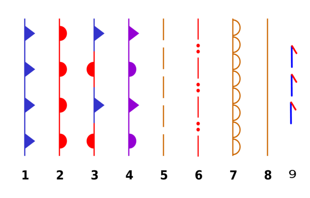
What does symbol # 3 mean?
a)
stationary front
b)
occluded front
c)
warm front
d)
cold front
2.
A front is
a)
where warm air is cooling at earth's surface
b)
a line where hot and cold air are separating
c)
a line where two different air masses meet
d)
where cold air is rising and forming rain clouds
3.
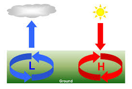
Which system results in drier, fairer weather?
a)
high pressure
b)
low pressure
c)
hurricane
d)
weather system
4.
rapidly moving cold air mass runs into a warm air mass the cold air slides under the warm air. This is called a .....
a)
cold front
b)
warm front
c)
stationary front
5.
When a warm air mass gently slides on top of a cold air mass, and you have drizzly rain and then warmer weather, what type of front is it?
a)
warm front
b)
cold front
c)
occluded front
d)
stationary front
6.
What types of air masses form over oceans?
a)
Maritime
b)
Continental
c)
Polar
d)
Tropical
7.
What's the humidity and temperature of a continental tropical air mass?
a)
Wet and cold
b)
Dry and warm
c)
Wet and warm
d)
Dry and cold
8.
What's the humidity and temperature of a maritime tropical air mass?
a)
Wet and cold
b)
Dry and warm
c)
Wet and warm
d)
Dry and cold
9.
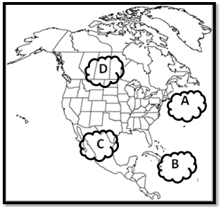
Which type of air would you find at air mass A?
a)
cold, dry
b)
warm, humid
c)
warm, dry
d)
cold, humid
10.
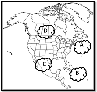
Which type of air would you find at air mass B?
a)
cold, dry
b)
warm, humid
c)
warm, dry
d)
cold, humid
11.
What makes a tornado?
a)
warm front
b)
cold front
c)
when warm and cold fronts come together
12.
What is a Fujita Scale of Tornado Intensity?
a)
A scale to find the epicenter.
b)
Rating scale of Tornado wind speed and damage.
c)
Rating scale of how long a Tornado is.
d)
Rating scale of damage caused.
13.
What is the area most commonly called that tornadoes travel through?
a)
Tornado lane
b)
The track of Tornadoes
c)
Tornado Alley
d)
Thunder Alley
14.
Why does the air mass of the hurricane rotate counterclockwise in the Northern Hemisphere?
a)
because of the uneven heating from the sun
b)
because of the upwelling of warm water in the ocean where it forms
c)
because the Northern Hemisphere is moving faster than the Southern Hemisphere causing spinning
d)
because the spinning of the earth causes the Coriolis effect
15.
Why does cold water or land cause a hurricane to weaken?
a)
because the high pressure of the hurricane can't handle the cold water from a low pressure system
b)
because the land always cools faster than the ocean
c)
because the land breeze shreds the hurricane
d)
because they cut off the energy supply to the hurricane
16.
How many categories of hurricanes
a)
2
b)
3
c)
4
d)
5
17.

According to this weather map, where is there cloudy skies and possibly rain?
a)
Denver
b)
Los Angles
c)
New York
d)
Chichago
18.

According to the isobars, which state is the windiest?
a)
Pennsylvania
b)
Wyoming
c)
Georgia
d)
Kansas
19.

What direction is the wind moving on this map?
a)
East
b)
Southeast
c)
South
d)
Northwest
20.

A cold front is approaching Minneapolis. What will happen to the air temperature?
a)
stay the same
b)
increase
c)
decrease
21.

Which city can expect to see an increase in temperatures over the next 24 hours?
a)
Billings, Montana
b)
Atlanta, Georgia
c)
Minneapolis, Minnesota
d)
Miami, Florida
22.

At which weather station is the cloud cover the least?
a)
Washington
b)
Decorah
c)
Keokuk
d)
They all have the same wind speed
23.
At which weather station is the temperature the highest?
a)
Washington
b)
Decorah
c)
Keokuk
d)
They all have the same wind speed
100 %

