
 Worksheets
Weather Review
Total questions: 67
Worksheet time: 1hrs 25mins
Name
Class
Date
1.

What does this symbol on a weather map indicate?
a)
High pressure system
b)
Low pressure system
c)
Cold front
d)
Warm front
2.

What does this symbol indicate on a weather map?
a)
High pressure system
b)
Low pressure system
c)
Cold front
d)
Warm front
3.
What kind of weather is usually associated with a high pressure system?
a)
Sunny weather
b)
Precipitation (rain, snow, etc.)
4.
Which weather tool measures air pressure?
a)
thermometer
b)
barometer
c)
anemometer
d)
psychrometer
5.
This weather tool measures wind speed and direction
a)
thermometer
b)
barometer
c)
anemometer
d)
psychrometer
6.
Which weather tool measures temperature?
a)
thermometer
b)
barometer
c)
psychrometer
d)
anememeter
7.
The boundary between two air masses is known as:
a)
front
b)
storm
c)
climate
d)
flood
8.
Mark looks at the clouds in the sky and decides that he does not need to
take his umbrella with him today. Which clouds did Mark most likely see
in the sky?
take his umbrella with him today. Which clouds did Mark most likely see
in the sky?
a)
cirrus
b)
nimbostratus
c)
cumulonimbus
9.
Which type of cloud is most often observed during a thunderstorm?
a)
cirrus
b)
stratus
c)
cumulus
d)
cumulonimbus
10.
Cold air (RISES/ FALLS) _________.
a)
RISES
b)
FALLS
11.
Which condition usually means cloudy, stormy weather?
a)
high pressure
b)
low pressure
12.

name this front
a)
warm front
b)
cold front
c)
stationary front
d)
occluded front
13.
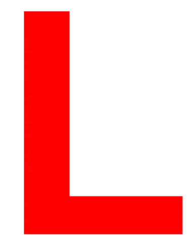
What does this symbol on a weather map indicate?
a)
High pressure system
b)
Low pressure system
c)
Cold front
d)
Warm front
14.

A _____ is a large, swirling, low-pressure system that forms over the Atlantic Ocean.
a)
blizzard
b)
cold front
c)
tornado
d)
hurricane
15.

A violently rotating column of air called a _____ when it comes in contact with the ground.
a)
hurrican
b)
tornado
c)
trade wind
d)
local wind
16.
Rain, snow, sleet, and hail are all forms of _____.
a)
precipitation
b)
condensation
c)
evaporation
d)
climate
17.
When a warm air mass gently slides on top of a cold air mass, and you have drizzly rain and then warmer weather, what type of front is it?
a)
warm front
b)
cold front
c)
occluded front
d)
stationary front
18.

What type of storm front is this?
a)
warm front
b)
cold front
c)
stationary front
d)
occluded front
19.
Where the warm and cold air meet and stall, clouds and fog form, and it may rain or snow. It could bring many days of clouds and precipitation.
a)
Warm Front
b)
Cold Front
c)
Occluded Front
d)
Stationary Front
20.
When a cold front overtakes a warm front, the temperature drops as the warm air mass is cut off from the ground and pushed upward. It can bring strong winds and heavy precipitation.
a)
Warm Front
b)
Cold Front
c)
Occluded Front
d)
Stationary Front
21.

This is the symbol for a...
a)
Stationary Front
b)
Occluded Front
c)
Cold Front
d)
Warm Front
22.
This severe weather involves low temperatures and snow either falling or drifting
a)
hurricane
b)
thunderstorm
c)
tornado
d)
blizzard
23.
This severe weather involves lightning, rain, and possibly hail
a)
thunderstorm
b)
tornado
c)
hurricane
d)
blizzard
24.
The boundary between two air masses is known as:
a)
front
b)
storm
c)
climate
d)
flood
25.
Cold air traveling south from Canada is:
a)
continental tropical
b)
continental polar
c)
maritime tropical
d)
maritime polar
26.
Warm air moving upwards from the Gulf of Mexico is:
a)
continental tropical
b)
continental polar
c)
maritime tropical
d)
maritime polar
27.
Warm air mass that does not carry water:
a)
continental tropical
b)
continental polar
c)
maritime tropical
d)
maritime polar
28.
Cold air mass that is carrying water is:
a)
continental tropical
b)
continental polar
c)
maritime tropical
d)
maritime polar
29.
Which weather tool measures air pressure?
a)
thermometer
b)
barometer
c)
anemometer
d)
psychrometer
30.
________________ are made of water vapor that condenses in the troposphere.
a)
dew
b)
clouds
c)
evaporation
d)
transpiration
31.
Warm air near the Earth’s surface rises and then cools and drops, this creates a _________________ in the atmosphere.
a)
run-off
b)
Greenhouse Effect
c)
convection current
d)
water cylce
32.
Because the earth is spinning on its axis, the global winds appear to curve. This is known as the __________ ________.
a)
Coriolis Effect
b)
Greenhouse Effect
c)
Climate Effect
d)
Atmosphere Effect
33.
Where does a hurricane form?
a)
Over a cold body of water
b)
Over a warm body of water
c)
Over cold land
d)
Over warm land
34.
In what direction do winds always blow?
a)
From areas of high pressure to areas of low pressure
b)
From areas of low pressure to areas of high pressure
35.
What layer does weather occur in?
a)
mesosphere
b)
troposphere
c)
thermosphere
d)
stratosphere
36.

What type of cloud looks like cotton and is in the lower altitudes?
a)
Cumulus
b)
Stratus
c)
Cirrus
37.
What are the daily conditions of temperature, humidity and precipitation?
a)
weather
b)
climate
38.
What are the yearly conditions of temperature, precipitation and humidity?
a)
weather
b)
climate
39.
As your distance from the equator increases, what happens to temperature?
a)
temperature increases
b)
temperature decreases
40.
Which climate zone gets the most amount of direct sunlight and rainfall and is the warmest?
a)
tropical
b)
temperate
c)
polar
41.
True or False? Warm and cold ocean currents affect the land nearby.
a)
false
b)
true
42.

This weather tool is used to measure...
a)
Temperature
b)
Rainfall
c)
Wind Speed
d)
Humidity
43.

This weather tool is used to determine...
a)
Temperature
b)
Wind Vain
c)
Wind Direction
d)
Rainfall
44.

What type of clouds are pictured?
a)
Cumulous
b)
Stratus
c)
Cirrus
45.

What type of cloud is pictured?
a)
Cirrus
b)
Stratus
c)
Cumulous
d)
Nimbus
46.

What type of cloud is pictured?
a)
Cirrus
b)
Stratus
c)
Cumulous
d)
Nimbus
47.

An instrument that measures air pressure
a)
thermometer
b)
barometer
c)
rain guage
d)
wind sock
48.
Which of the following are used to study and forecast most weather-related events?
a)
Doppler radar
b)
satellites and satellite images
c)
weather maps
d)
all of the above
49.
Which of the following will heat the fastest?
a)
water
b)
land
c)
both heat at equal rates
50.
What are the two main factors that determine the climate of an area?
a)
precipitation and humidity
b)
temperature and air pressure
c)
wind conditions and humidity
d)
temperature and precipitation
51.
What causes winds to form on Earth?
a)
solar energy
b)
ocean currents
c)
elevation differences
d)
uneven heating of the Earth by the sun
52.
Which BEST describes why latitudes closest to the equator have warmer climates?
a)
they are at lower elevations
b)
they receive more solar energy
c)
they are nearer to ocean currents
d)
they get more winds that carry energy in the form of heat
53.

A cold front is approaching Minneapolis. What will happen to the air temperature?
a)
stay the same
b)
increase
c)
decrease
54.
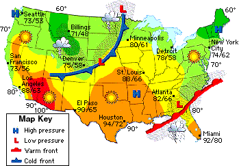
A low pressure system is located over Georgia. What type of weather will they have?
a)
clear, sunny skies
b)
cloudy and rainy
55.
A high pressure system is located north of New York City. What type of weather will be experienced there?
a)
clear, sunny skies
b)
cloudy and rainy
56.

Which city is experiencing thunderstorms?
a)
Denver
b)
New York
c)
Miami
d)
Boise
57.

Which city is currently experiencing a snow storm?
a)
Seattle
b)
Los Angeles
c)
Chicago
d)
New York
58.

Which city has the highest the highest temperature?
a)
Dallas
b)
Chicago
c)
Los Angeles
d)
Miami
59.

Which city has the lowest temperature on the map?
a)
Minneapolis
b)
Seattle
c)
New York
d)
Denver
60.

Which city is close to a warm front?
a)
Chicago
b)
New York
c)
Boise
d)
Denver
61.

Which city is experiencing cloudy skies and rain?
a)
New York
b)
Seattle
c)
Dallas
d)
Boise
62.
In which direction do weather patterns move in the United States?
a)
south to north
b)
west to east
c)
east to west
63.
Which best describes the Gulf Stream?
a)
an ocean current which originates
in the Gulf of Mexico and causes
warm water to travel up the east
coast of the United States
b)
an ocean current which originates
in the Gulf of Mexico and
causes cool water to travel up the
east coast of the United States
c)
an ocean current which originates
in the Gulf of Mexico and
causes warm water to travel down
the east coast of Mexico
d)
an ocean current which originates
in the Gulf of Mexico and causes
cool water to travel down the
east coast of Mexico
64.
Which best describes a characteristic of the jet stream?
a)
It forms a boundary between a cold air mass and a warm air mass.
b)
It creates the high winds around the eye of a hurricane.
c)
It forces the hot air along the equator to rise to areas in North America.
d)
It causes high pressure air masses to rotate clockwise.
65.
What do meteorologists make from weather data?
a)
tornadoes
b)
forecasts
c)
cold fronts
d)
all of the above
66.
What is a meteorologist?
a)
A type of cloud.
b)
A weather instrument.
c)
A scientist who studies weather.
d)
A person who likes weather.
67.
Weather stations are set up all over the world.
a)
True
b)
False
100 %

