
 Worksheets
Geography Pretest
Total questions: 50
Worksheet time: 39mins
Name
Class
Date
1.

What is the approximate location of letter B?
a)
80oN, 0o
b)
0o, 80oW
c)
80oS, 0o
d)
0o, 80oE
2.

What is the absolute location for G?
a)
45oS, 54oE
b)
30oS, 150oW
c)
150oS, 30oE
d)
30oS, 150oE
3.

a)
The map show the lines of longitude.
b)
The map shows the lines of latitude.
4.

a)
The map shows lines of longitude.
b)
The map shows lines of latitude.
5.
What is a Region
a)
Tells us ways in which the places in an area are alike
b)
Tells us what makes an area special and what makes it different from every other area
c)
Tells us where people and places are
6.
What is movement?
a)
Tells us how people, goods, recourses, and ideas move from one place to another
b)
Tells us what makes an area special and what makes it different from every other area
c)
Tells us ways in which the places in an area are alike.
7.
What is location?
a)
Tells us where people and places are
b)
Tells us what makes an area special and what makes it different from every other area.
c)
Tells how people, goods, resources, and ideas move from one place to another.
8.
Cutting down trees to build houses is an example of which?
a)
Location
b)
Place
c)
Human-Environment Interaction
d)
Movement
9.
The imaginary line that runs through the middle of the earth east and west is called?
a)
Prime Meridian
b)
Equator
c)
Date Line
10.
The fact that Africa is south of Europe is an example of which?
a)
Movement
b)
Absolute Location
c)
Relative Location
d)
Place
11.
Where is it exactly on the Earth?
a)
Place
b)
Perfect Location
c)
Absolute Location
d)
Relative Location
12.
An area, often covered within sand, where there is very little rain
a)
a valley
b)
a waterfall
c)
a desert
13.

A ____ is a large area of flat land with few trees usually suitable to grow crops.
a)
grazing
b)
cattle
c)
plain
d)
plane
14.
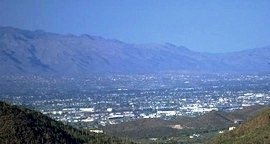
Low areas between mountains or other high areas; are often formed by rivers or glaciers
a)
valleys
b)
rivers
c)
plateaus
d)
mountains
15.
A deep, narrow valley with steep sides
a)
Canyon
b)
Desert
c)
Drought
d)
Adobe
16.
The action of water, wind, or ice in wearing away soil and rock
a)
Erosion
b)
Adapt
c)
Desert
d)
Butte
17.
A land form that is a flat-topped hill with steep sides
a)
Refinery
b)
Mesa
c)
Mountain
d)
Adobe
18.
A period in which very little rain falls
a)
Desert
b)
Adobe
c)
Drought
d)
Pueblo
19.
Which state is NOT in the Southwest region?
a)
California
b)
Texas
c)
Oklahoma
d)
New Mexico
20.
What major river is found in this region?
a)
Hudson
b)
Mississippi
c)
Rio Grande
d)
Missouri
21.
What is the climate of the SW like?
a)
cool climate with snowy mountains
b)
warm, tropical rainforest
c)
hot, dry summers & cool, wet winters
d)
warm, dry deserts & lowlands
22.
What is the water cycle?
a)
the 3 forms of water
b)
the movement of water on, above, or below the surface of the Earth
c)
when water melts
d)
when clouds form
23.
Which of these is an example of precipitation?
a)
snow
b)
air
c)
clouds
d)
vapor
24.

After the rain falls down onto Earth's surface, what most likely happens? What is it called?
a)
1. The remains of the water is soaked into the ground.
2.Groundwater
2.Groundwater
b)
1. Groundwater
2. The remains of the water is soaked into the ground.
2. The remains of the water is soaked into the ground.
c)
1. Groundwater
2. Transpiration happens to the plants.
2. Transpiration happens to the plants.
d)
1. The liquid turns into an gas or an water vapor
2. Evaporation
2. Evaporation
25.
What state is not a border state of New Mexico?
a)
Kansas
b)
Arizona
c)
Oklahoma
d)
Colorado
26.
What are the four oceans of the world?
a)
Pacific, Atlantic, Indian, Mediterrean
b)
Pacific, Atlantic, Rio Grande, Arctic
c)
Pacific, Atlantic, Arctic, Indian
d)
Asia, Europe, Australia, Atlantic
27.
What are the four geographic regions in New Mexico?
a)
Mountain, Plains, Santa Fe, Indian
b)
Plateau, Plains, Kansas, Basin
c)
Basin and Range, New Mexico, irrigation, altitude
d)
Mountains, Plateau, Plains, Basin and Range
28.
What geographic region in NM gets the most amount of rainfall?
a)
plateau
b)
mountains
c)
basin and range
d)
plains
29.
What determines where people can live?
a)
shopping
b)
weather
c)
water
d)
mountains
30.
What is altitude?
a)
number of feet below sea level
b)
your behavior in class
c)
number of feet above sea level
d)
the height of a person
31.
Irrigation is
a)
growing farms
b)
bringing water to crops
c)
taking salt of water
d)
the rainy season
32.
New Mexico's rainy season happens between
a)
June and September
b)
January and March
c)
October and December
d)
Tuesday and Thursday
33.
New Mexico's water resources are
a)
oceans, lakes, ponds
b)
rivers, wells, faucets
c)
surface, ground, rainfall
d)
surface, rainfall, oceans
34.
What is the geographic region that gets the least amount of rainfall?
a)
basin and range
b)
mountains
c)
plains
d)
desert
35.

a)
Africa
b)
Asia
c)
Europe
d)
South America
36.

a)
Africa
b)
Antarctica
c)
Australia Oceania
d)
South America
37.

a)
Atlantic Ocean
b)
Indian Ocean
c)
Pacific Ocean
d)
Arctic Ocean
38.

a)
Asia
b)
Africa
c)
North America
d)
Australia Oceania
39.

a)
Arctic Ocean
b)
Atlantic Ocean
c)
Indian Ocean
d)
Pacific Ocean
40.

a)
North America
b)
Europe
c)
Africa
d)
Asia
41.

a)
Indian Ocean
b)
Arctic Ocean
c)
Pacific Ocean
d)
Atlantic Ocean
42.

a)
Asia
b)
South America
c)
North America
d)
Europe
43.

a)
Atlantic Ocean
b)
Arctic Ocean
c)
Indian Ocean
d)
Pacific Ocean
44.

a)
Africa
b)
South America
c)
Europe
d)
Asia
45.

a)
Asia
b)
Africa
c)
North America
d)
Australia Oceania
46.

This map is an example of a . . .
a)
Political Map
b)
Physical Map
c)
Population Map
d)
Thematic Map
47.

This map is an example of a . . .
a)
Political Map
b)
Land Use Map
c)
Physical Map
d)
Thematic Map
48.
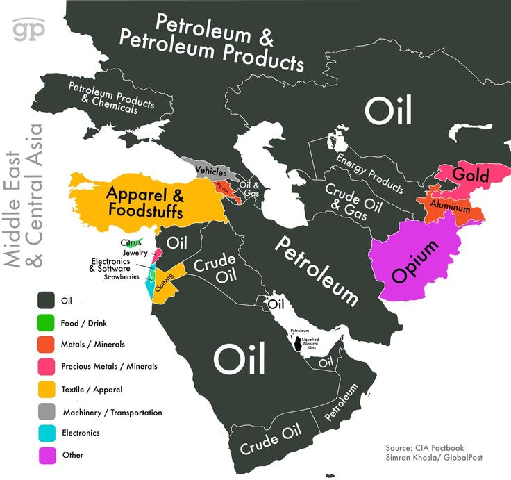
This map is an example of a . . .
a)
Political Map
b)
Physical map
c)
Land Use and Resource Map
d)
Historical Map
49.
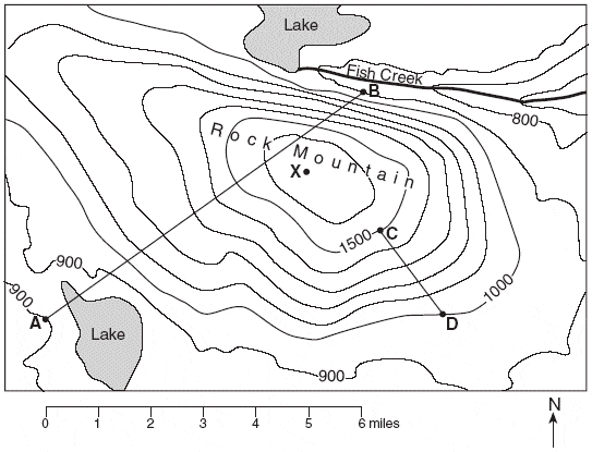
This map is an example of a . . .
a)
Topographic Map
b)
Political Map
c)
Thematic Map
d)
Land Use Map
50.

This map is an example of a . . .
a)
Physical Map
b)
Thematic Map
c)
Population Map
d)
Climate Map
100 %

