wayground logo

Free Printable Worksheets

NEW

Font size

S
M
L
XL
Worksheets

Geography Test Review

Total questions: 37

Worksheet time: 32mins

Name
Class
Date
1.
The 0 degree line of latitude is the ___________.
a)
Equator
b)
Prime Meridian
c)
International Date Line
d)
Contour line
2.
The 0 degree mark of longitude is known as the ___________ ______________ measure from Greenwich England.
a)
Equator
b)
Prime Meridian
c)
International Date Line
d)
Contour Line
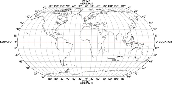
3.
What is the approximate location of letter B?
a)
80oN, 0o
b)
0o, 80oW
c)
80oS, 0o
d)
0o, 80oE
4.
What is the approximate location of G?
a)
100oW, 40oN
b)
40oN, 100oW
c)
40oS, 100oW
d)
40oN, 100oE
5.
Which of the following letter is at approximately 60 degrees S, 40 degrees W? 
a)
A
b)
D
c)
E
d)
H
6.
a)
The map show the lines of longitude.
b)
The map shows the lines of latitude.
7.
a)
The map shows lines of longitude.
b)
The map shows lines of latitude.
8.
Look at the map- which side of this map is east?
a)
top
b)
bottom
c)
left
d)
right
9.
Which side of this map is west?
a)
top
b)
bottom
c)
left
d)
right
10.
The average weather in an area.  The average temperature in a region.  The typical wind conditions that may occur.  These three statements all describe? 
a)
Weather
b)
Physical Maps
c)
Climate
d)
Landforms
11.
A map that shows physical features and landforms is called?
a)
Physical Map
b)
Growth Map
c)
Projection Map
d)
Political Map
12.
What type of map would you need to use to see a country's boundaries?
a)
Physical Map
b)
Robinson Projection Map
c)
Political Map
d)
Globe
13.
Which of the following best describes weather?
a)
day to day conditions of the atmosphere at a place in regards to heat, dryness, sunshine, wind, rain, etc.
b)
long-term conditions (30 or more years) of the atmosphere at a place in regards to heat, dryness, sunshine, wind, rain, etc.
14.
Which of the following best describes climate?
a)
day to day conditions of the atmosphere at a place in regards to heat, dryness, sunshine, wind, rain, etc.
b)
long-term conditions (30 or more years) of the atmosphere at a place in regards to heat, dryness, sunshine, wind, rain, etc.
15.
The study of the Earth and the way people live and use it.
a)
Geology
b)
Genome
c)
Geography
d)
Geode
16.
Which part of the map show the directions?
a)
Map Title
b)
Compass Rose
c)
Map key or legend
d)
Grid Lines
17.
Which of the following is NOT a cardinal direction?
a)
North
b)
West
c)
Southeast
d)
East
18.
A Map key, scale and title does what?
a)
get into somewhere
b)
Helps you to read and understand a map
c)
know how much you weigh
d)
get out of somewhere
19.

What is a Region

a)

Tells us ways in which the places in an area are alike

b)

Tells us what makes an area special and what makes it different from every other area

c)

Tells us where people and places are

d)

Shows the movement of people

20.

What is movement?

a)

Tells us how people, goods, recourses, and ideas move from one place to another

b)

Tells us what makes an area special and what makes it different from every other area

c)

Tells us ways in which the places in an area are alike.

d)

Tells us the weather and climate of a location

21.

What is location?

a)

Tells us where people and places are

b)

Tells us what makes an area special and what makes it different from every other area.

c)

Tells how people, goods, resources, and ideas move from one place to another.

d)

Shows us the movement of people in an area

22.
Cutting down trees to build houses is an example of which?
a)
Location
b)
Place
c)
Human-Environment Interaction
d)
Movement
23.
The Five Themes of Geography are the Following:
a)
Place, Region, Interaction, Land-forms, Movement
b)
Place, Region, Interaction, Location, Movement
c)
People, Race, Interaction, Location Movement
d)
Power, Region, Interaction, Location Movement
24.
This theme of Geography describes what the location is like. 
a)
Absolute Location
b)
Relative Location
c)
Place
d)
Region
25.
How people and their surroundings interact
a)
human/environment interaction
b)
Place
c)
Region
d)
Location
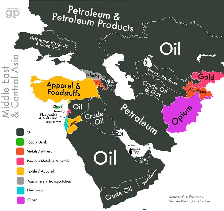
26.
This map is an example of a . . . 
a)
Population Map
b)
Thematic Map
c)
Climate Map
d)
Land Use and Resources Map
27.
This map is an example of a . . . 
a)
Climate Map
b)
Land Use Map
c)
Historical Map
d)
Topographic Map
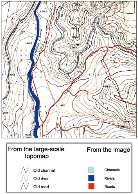
28.
This map is an example of a . . . 
a)
Political Map
b)
Physical map
c)
Land Use and Resource Map
d)
Historical Map
29.
Which is more specific when discussing location?
a)
Command
b)
Relative
c)
Scientific
d)
Absolute
30.
Which continent is located at 60° N and 120° W
a)
North America
b)
South America
c)
Asia
d)
Europe
31.

What direction is indicated by the number 6?

a)

north

b)

east

c)

south

d)

west

32.
What direction is indicated by the number 2?
a)
north
b)
east
c)
south
d)
west
33.
What direction is indicated by the number 4?
a)
north
b)
east
c)
south
d)
west
34.
What direction is indicated by the number 1?
a)
northeast
b)
northwest
c)
southeast
d)
southwest
35.
What direction is indicated by the number 3?
a)
northeast
b)
northwest
c)
southeast
d)
southwest
36.

What direction do you need to travel to go from the ferris wheel to the Food Market?

a)

South

b)

North

c)

Northwest

d)

East

37.

What direction do you need to travel to get from the swing set to the food market?

a)

East

b)

North

c)

Southeast

d)

West