
 Worksheets
Mapping
Total questions: 40
Worksheet time: 33mins
Name
Class
Date
1.

What is the continent that is pink?
a)
North America
b)
South America
c)
Asia
d)
Australia
2.

What is the continent that is blue?
a)
Africa
b)
Australia
c)
Antarctica
d)
Asia
3.

What is the continent that is red?
a)
North America
b)
Europe
c)
Africa
d)
Australia
4.

What is the continent that is dark green?
a)
North America
b)
South America
c)
Europe
d)
Australia
5.

What is the continent that is yellow?
a)
Africa
b)
Australia
c)
Asia
d)
Antarctica
6.

What is the continent that is light green?
a)
North America
b)
South America
c)
Africa
d)
Australia
7.
How many continents are there in the world?
a)
4
b)
5
c)
6
d)
7
8.

What is the continent that is orange?
a)
Africa
b)
Australia
c)
Antarctica
d)
Asia
9.
A list that explains the symbols on a map.
a)
legend (key)
b)
compass rose
c)
inset map
d)
cardinal directions
10.
What is a ruler that measures distance?
a)
compass rose
b)
index
c)
scale
d)
inset map
11.

Name the part of the map labeled with a "C."
a)
Key
b)
Title
c)
Compass Rose
12.

What does the red line in the picture show?
a)
Prime Meridian
b)
Equator
c)
continents
d)
countries
13.

What is the grid reading for the forest?
a)
6F
b)
3B
c)
7D
d)
3F
14.
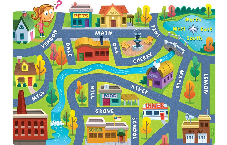
The school is ____ of the pet store.
a)
North
b)
South
c)
East
d)
West
15.
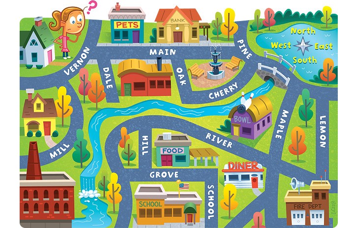
The bank is ____ of the pet store.
a)
East
b)
North
c)
West
d)
South
16.

What is located at grid location 6E?
a)
Waterhole
b)
Mine
c)
National Park
d)
Lake
17.

What direction is indicated by the number 3?
a)
northeast
b)
northwest
c)
southeast
d)
southwest
18.

What direction is indicated by the number 7?
a)
northeast
b)
northwest
c)
southeast
d)
southwest
19.

What is this symbol?
a)
scale
b)
key
c)
compass rose
d)
map
20.
distance in degrees east or west of the Prime Meridian
a)
latitude
latitude
latitude
b)
longitude
longitude
longitude
21.
Distance in degrees north or south of the equator
a)
latitude
b)
longitude
22.

a map feature that explains the meaning of colors and symbols used on the map
a)
Map Key
b)
Map Contents
c)
Map Glossary
d)
Map Index
23.

a map feature that compares distance on a map to the real distance
a)
Scale
b)
Odemeter
c)
Latitude
d)
Longitude
24.

imaginary lines on a map that run east and west (horizontal)
a)
Latitude
b)
Longitude
25.

imaginary lines on a map that run up and down (vertical)
a)
Latitude
b)
Longitude
26.

the hemisphere that is NORTH of the Equator
a)
Northern Hemisphere
b)
Southern Hemisphere
c)
Eastern Hemisphere
d)
Western Hemisphere
27.

the hemisphere that is SOUTH of the Equator
a)
Northern Hemisphere
b)
Southern Hemisphere
c)
Eastern Hemisphere
d)
Western Hemisphere
28.

the hemisphere that is EAST of the Equator
a)
Northern Hemisphere
b)
Southern Hemisphere
c)
Eastern Hemisphere
d)
Western Hemisphere
29.

the hemisphere that is WEST of the Equator
a)
Northern Hemisphere
b)
Southern Hemisphere
c)
Eastern Hemisphere
d)
Western Hemisphere
30.
What is a compass rose?
a)
Idaho's state flower
b)
a flower on a map
c)
a symbol which shows directions
d)
a symbol which shows colors
31.
A flat drawing that shows all or part of the Earth's surface
a)
map
b)
latitude
c)
globe
32.

Name Continent B!
a)
Asia
b)
Europe
c)
South America
33.

Name Continent A!
a)
North America
b)
Africa
c)
South America
34.

Name Continent C!
a)
Antarctica
b)
Europe
c)
North America
35.

Name Continent D!
a)
Australia
b)
North America
c)
Aisia
36.

Continent E is ________.
a)
North America
b)
Africa
c)
Antarctica
37.

Continent F is ________.
a)
Antarctica
b)
Australia
c)
North America
38.

a)
The purpose of a map scale is to measure the wind.
b)
The purpose of a map scale is to measure distances.
c)
The purpose of a map scale is to tell direction.
39.

a)
A map key gives direction on a map.
b)
A map key explains what the colors and symbols mean on a map.
c)
A map key helps you find distance.
40.
A sphere shaped representation of the world is a
a)
cardinal rose
b)
map
c)
globe
100 %

