
 Worksheets
Map Skills
Total questions: 15
Worksheet time: 14mins
Name
Class
Date
1.
What IS NOT a part of most maps?
a)
Compass Rose
b)
Title
c)
Symbols/Key
d)
People
2.
North, South, East and West are referred to as the _________directions.
a)
raven
b)
bluejay
c)
cardinal
d)
robin
3.
Which direction normally is pointing to the top of the page on a map?
a)
North
b)
South
c)
East
d)
West
4.
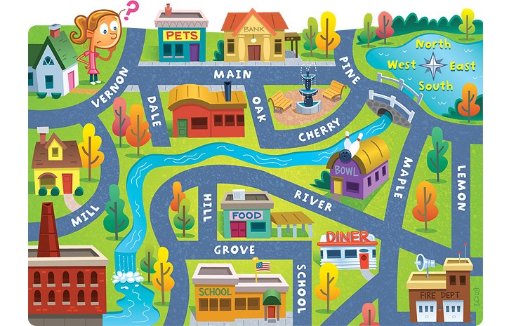
The bank is on what street?
a)
Main
b)
Maple
c)
Lemon
d)
River
5.
If a map’s scale shows that 1-inch on the map equals 1 mile in real life, how many inches on the map would stand for 2 miles?
a)
2 inches
b)
4 inches
c)
1 inch
d)
3 inches
6.
How can you identify the scale on a map?
a)
It looks like a ruler.
b)
It has a list of symbols
c)
It has different colors.
d)
It’s always round
7.

Name river number 3.
a)
Colorado River
b)
Ohio River
c)
Rio Grande
d)
Mississippi River
8.

What large mountain range is pictured here?
a)
Catskill Moutains
b)
Rocky Moutanins
c)
Appalachian Mountains
9.
Which statement is true about the imaginary line that runs around the middle of Earth?
a)
It tells what day it is.
b)
It’s called the equator.
c)
It’s a line of longitude.
d)
It’s called the prime meridian.
10.

What is the name of the mountain range located on the west side of the United States?
a)
Atlas Mountains
b)
Rocky Mountains
c)
Sierra Madre
d)
Appalachian
11.

Washington, D.C. is located on which coast of the United States?
a)
North Coast
b)
East Coast
c)
South Coast
d)
West Coast
12.

This is a map of….
a)
North Carolina
b)
United States of America
c)
The World
d)
Davidson County
13.

The capital of Texas is
a)
Houston
b)
Austin
c)
Dallas
d)
San Antonio
14.

What is the tool on the map that shows you the directions?
a)
compass rose
b)
scale
c)
key
15.

What continent do you live on?
a)
South America
b)
North America
c)
USA
d)
Canada
100 %

