
 Worksheets
Unit One Test Review
Total questions: 22
Worksheet time: 25mins
Name
Class
Date
1.
0 degrees latitude is known as the
a)
Equator
b)
Prime Meridian
c)
International Date Line
d)
North Pole
2.
The Prime Meridian is ________________________.
a)
180 degrees Longitude.
b)
0 degrees Latitude
c)
0 degrees Longitude
d)
90 degrees Latitude
3.
How many continents are there in the world?
a)
4
b)
5
c)
6
d)
7
4.
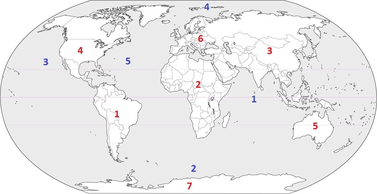
Which continent is located at #1?
a)
North America
b)
Antarctica
c)
South America
d)
Asia
5.
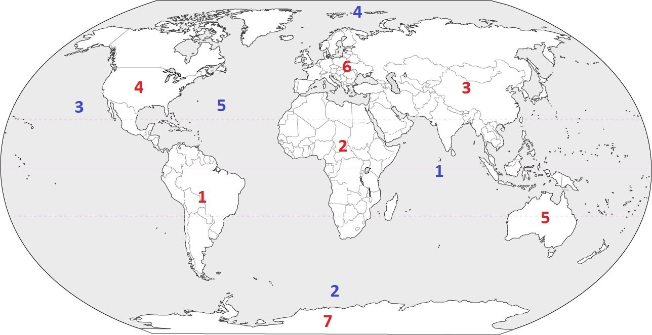
Which continent is located at #2?
a)
Africa
b)
South America
c)
Australia
d)
Europe
6.
The equator divides what two hemispheres?
a)
East and West
b)
North and South
7.
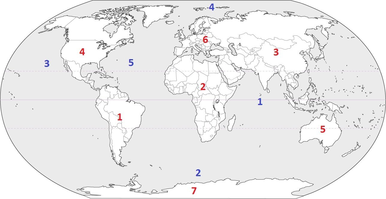
Which continent is located at #5?
a)
South America
b)
Asia
c)
Australia
d)
Antarctica
8.

What is this symbol?
a)
scale
b)
key
c)
compass rose
d)
map
9.

The continents located totally west of the Prime Meridian are:
a)
North American & South America
b)
North America & Asia
c)
South America & Australia
d)
Africa & Asia
10.

The continents located totally east of the Prime Meridian are:
a)
North America & South America
b)
North American & Asia
c)
Asia & Australia
d)
Africa & Asia
11.

Which of the following letter is at approximately 60 degrees S, 40 degrees W?
a)
A
b)
D
c)
E
d)
H
12.

Which letter would you find at 15oS, 60oW?
a)
A
b)
C
c)
L
d)
H
13.

A set of degrees of latitude and longitude that help you locate a place on a map.
a)
coordinates
b)
positions
c)
hemispheres
d)
locations
14.

What is the approximate location of letter B?
a)
80oN, 0o
b)
0o, 80oW
c)
80oS, 0o
d)
0o, 80oE
15.

What kind of map is this?
a)
Continental
b)
Political
c)
Flat
d)
Globe
16.
A map showing mountains, rivers, oceans, elevation is what type of map?
a)
Political
b)
Physical
c)
Thematic
d)
Nothing
17.
What is a map scale?
a)
a tool to measure distance
b)
a tool to tell direction
c)
a tool to start a fire
d)
a tool to build a house
18.

When measuring the distance of Wichita Falls to Dallas what Unit of measurement works best?
a)
Inches
b)
Feet
c)
Miles
d)
Yards
19.

What is the purpose of a map scale?
a)
To weigh the political power of the states
b)
To show where things are located on the map
c)
Compare the distance measured on the map to the actual distance on Earth
d)
To show how large the map is
20.

The Rio de Janiero is located in the ___ zone.
a)
Polar
b)
Tropic
c)
Temperate
21.

Dakar is located in the ___ zone.
a)
Polar
b)
Tropic
c)
Temperate
22.

Daneborg is located in the ___ zone.
a)
Polar
b)
Tropic
c)
Temperate
100 %

