wayground logo

Free Printable Worksheets

NEW

Font size

S
M
L
XL
Worksheets

Review 1

Total questions: 20

Worksheet time: 5hrs 0mins
Name
Class
Date
1.

The average number of people per square mile

a)

population distribution

b)

population density

c)

urbanization

d)

population rate

2.

Who creates the laws and is in charge of enforcing them?

a)

Politics

b)

Economics

c)

Achievements

d)

Geography

3.
Muslims take time to perform one of their 5 daily prayers.
a)
Religion
b)
Social Structures
c)
Religion and Economics
d)
Religion and Social Structures
4.
The USA lands the first man on the moon in 1969. 
a)
Achievements
b)
Geography
c)
Religion
d)
Social Structures
5.
Canada is __________ of the United States.
a)
South
b)
North
c)
Superior
d)
Beneath
6.
Mexico is __________ of the United States.
a)
A colony
b)
North
c)
Superior
d)
South
7.

_____ location is the exact spot on earth a place is found.

a)

absolute

b)

exact

c)

pinpoint

d)

accurate

8.
All of these resources are renewable EXCEPT:
a)
Oxygen
b)
Crude Oil
c)
Ice
d)
Corn
9.
A resource that is not easily replaced...
a)
Renewable
b)
Nonrenewable
10.
Which of these is renewable?
a)
Water
b)
Oil
c)
Coal
d)
Minerals
11.

The measurement of population per unit area or unit volume or the average number of people who live in a square mile is called ...

a)

population

b)

demographer

c)

population density

d)

population distribution

12.

What type of government is ruled by religion?

a)

Democracy

b)

Dictatorship

c)

Theocracy

d)

Totalitarian

13.
Name Continent C!
a)
Antarctica
b)
Europe
c)
Asia
d)
North America
14.
Continent F is ________.
a)
Antarctica
b)
Australia
c)
Europe
d)
North America
15.
Name Ocean #1!
a)
Indian
b)
Pacific
c)
Atlantic
d)
Southern
16.
Ocean #4 is ________.
a)
Indian
b)
Atlantic
c)
Pacific
d)
Southern
17.

What is the imaginary line of Latitude at 0 degrees?

a)

Equator

b)

Prime Meridian

c)

International Dateline

d)

The Moon

18.

What line of longitude is at o degrees?

a)

Equator

b)

Prime Meridian

c)

316

19.
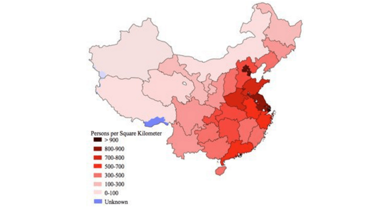
Which of these best explains the high population density in China's eastern region?
a)
The region is not capable of supporting large scale farming
b)
The region is close to the ocean and has favorable climate
c)
The region is home to the emperor 
d)
The region is located near active volcanoes
20.

What is this symbol?

a)

scale

b)

key

c)

compass rose

d)

map