
 Worksheets
Geography
Total questions: 29
Worksheet time: 20mins
Name
Class
Date
1.

What is the continent that is pink?
a)
North America
b)
South America
c)
Asia
d)
Australia
2.

What is the continent that is red?
a)
North America
b)
Europe
c)
Africa
d)
Australia
3.

What is the continent that is dark green?
a)
North America
b)
South America
c)
Europe
d)
Australia
4.

What is the continent that is yellow?
a)
Africa
b)
Australia
c)
Asia
d)
Antarctica
5.

What is the continent that is orange?
a)
Africa
b)
Australia
c)
Antarctica
d)
Asia
6.
How many continents are there in the world?
a)
4
b)
5
c)
6
d)
7
7.
How many oceans are there in the world?
a)
7
b)
6
c)
5
d)
4
8.
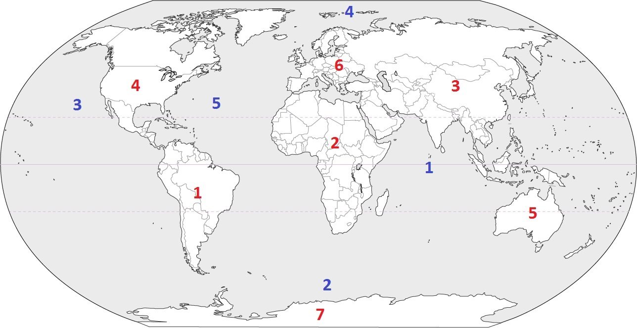
Identify the ocean at location #3
a)
Atlantic Ocean
b)
Arctic Ocean
c)
Pacific Ocean
d)
Indian Ocean
9.
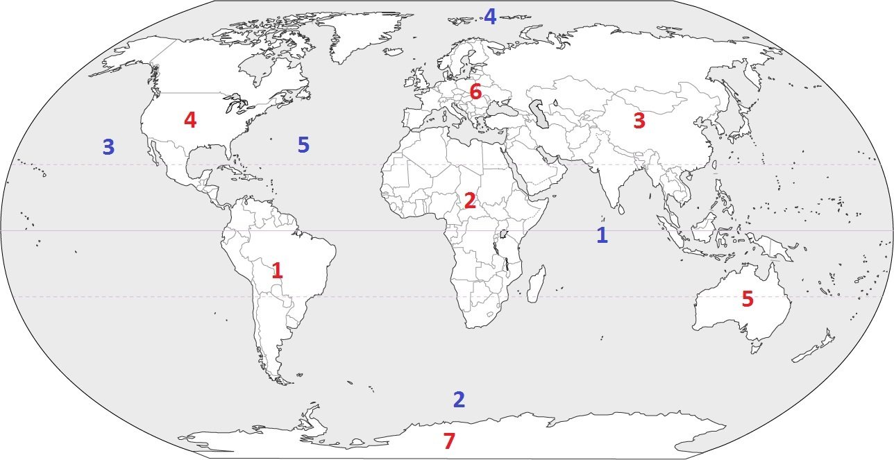
Identify the ocean at location #5
a)
Atlantic Ocean
b)
Southern Ocean
c)
Pacific Ocean
d)
Arctic Ocean
10.
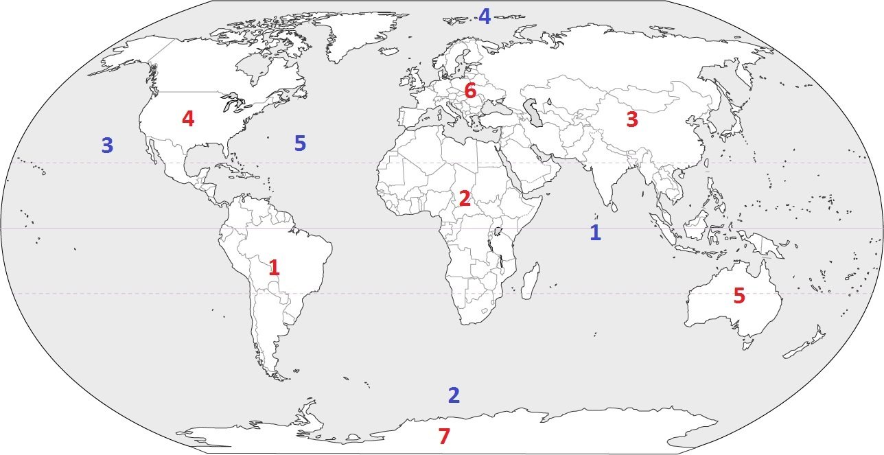
Identify the ocean at location #2
a)
Indian Ocean
b)
Pacific Ocean
c)
Southern Ocean
d)
Arctic Ocean
11.
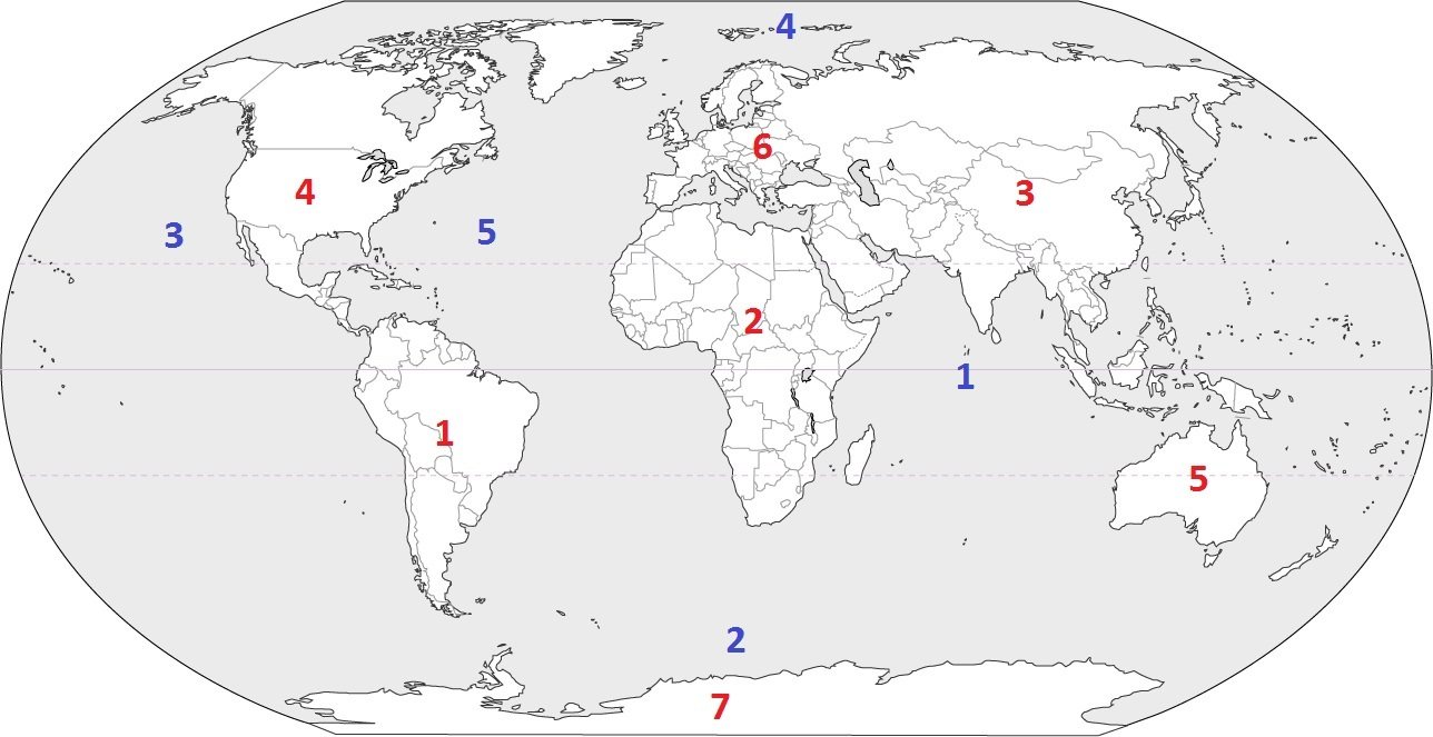
Identify the ocean at location #1
a)
Southern Ocean
b)
Arctic Ocean
c)
Atlantic Ocean
d)
Indian Ocean
12.
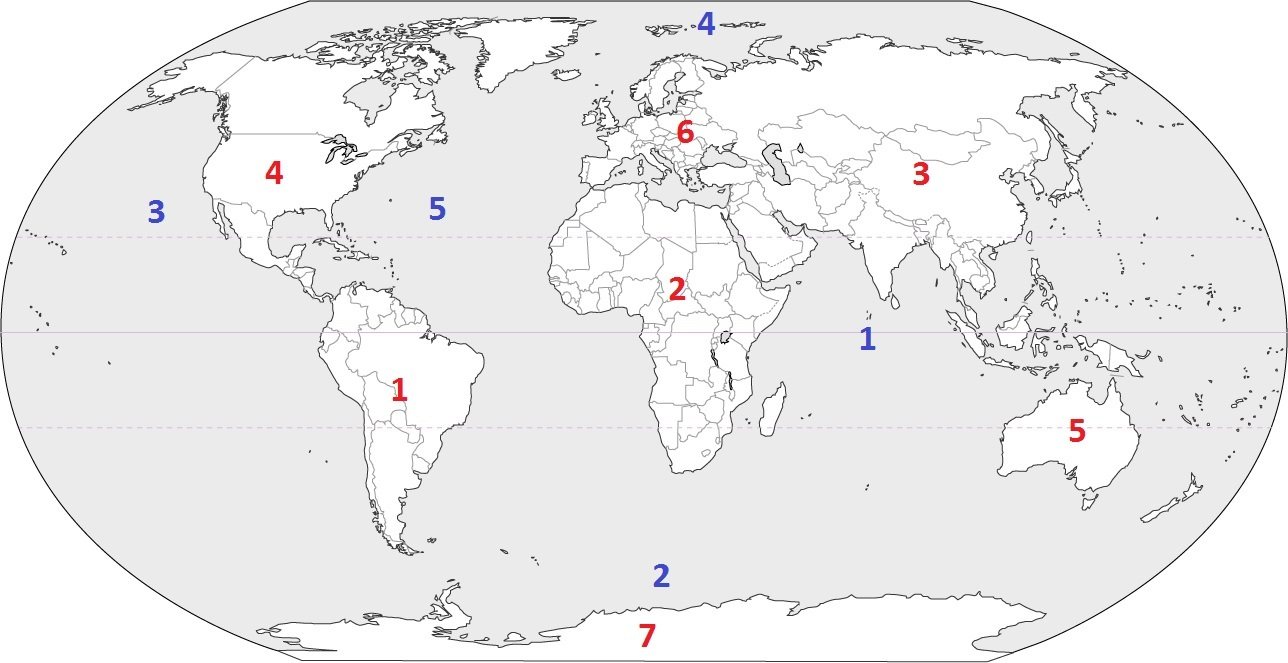
Identify the ocean at location #4
a)
Indian Ocean
b)
Pacific Ocean
c)
Arctic Ocean
d)
Atlantic Ocean
13.
The exact spot of a location on a map is called the ___________________________.
a)
Absolute Location
b)
Relative Location
c)
Exact Spot
d)
Right There
14.
Our Earth can be divided in half, either north and south or west and east. These halves are called ______________________.
a)
Pie
b)
Chunks
c)
Hempispheres
d)
Grids
15.
The title of a map tells us:
a)
What the map is about (the topic of the map)
b)
The distance the map covers
c)
The name of the cartogtrpaher
d)
That Mr. Scully is the bomb-diggity
16.
Which map element tells us the cardinal and intermediate directions?
a)
Scale
b)
Title
c)
Compass Rose
d)
Legend
17.
You can use a scale on a map to:
a)
Find out how much the map weighs
b)
Determine the distance from one point to another
c)
Understand the meaning of the map's symbols
d)
Dance the night away
18.
The purpose of a map legend (or key) is:
a)
To explain the history of the map
b)
To figure out the distance from one place to another
c)
To identify the meaning of symbols on the map
d)
To shampoo your hair, rinse, and repeat
19.
Lines that run west and east and measure distances in degrees from the Equator are called lines of ________________.
a)
Longitude
b)
Latitude
c)
Wrongitude
d)
Attitude
20.

California is ___ of Montana.
a)
Southwest
b)
Southeast
c)
Northwest
d)
Northeast
21.

Lake Plains are _____ of the Appalachian Plateaus.
a)
Southwest
b)
Northwest
c)
Northeast
d)
Southeast
22.

The Ohio River is _____ of Toledo.
a)
North
b)
East
c)
West
d)
South
23.
The states in the area known as the "Southwest" of the United States are often grouped together because they are very hot and dry desert-like areas.
a)
Region
b)
Location
c)
Human Environment Interaction
d)
Movement
24.
The Middle East is an example of which?
a)
Human-Environment Interaction
b)
Relative Location
c)
Movement
d)
Region
25.
People leaving their homes in Syria and travelling to Turkey to avoid ISIS is an example of which?
a)
Human-Environment Interaction
b)
Movement, push factor
c)
Movement, pull factor
d)
Relative Location
26.
Building dams, plowing and irrigating fields, and digging mines are examples of...
a)
depending
b)
adapting
c)
modifying
27.
People who live in the northeastern United States use heating units to keep their homes warm in winter. This is an example of..
a)
modifying
b)
adapting
c)
depending
28.
Two words, or characteristics, associated with "Place" are:
a)
human and physical
b)
push and pull
c)
common characteristics
d)
depend and adapt
29.
The two words associated with "Location" are:
a)
absolute and relative
b)
depend and adapt
c)
push and pull
d)
human and physical
100 %

