
NEW
Font size
S
M
L
XL
 Worksheets
Ocean Floor
Total questions: 29
Worksheet time: 19mins
Name
Class
Date
1.
The type of plate boundary where two plates come together is a .....
a)
Convergent Boundary
b)
Divergent Boundary
c)
Transform Boundary
d)
Plate Boundary
2.
Which of the following causes Earth's tectonic plates to move?
a)
Energy from the Sun
b)
Magnetic Pole Reversal
c)
Convection currents in the mantle
d)
Faults in Mountain Ranges
3.
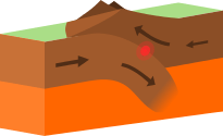
What type of plate boundary is this?
a)
Plate
b)
Divergent
c)
Convergent
d)
Transform
4.
A divergent boundary occurs when plates ....
a)
Pull apart
b)
Come together
c)
Slide past each other
d)
subducting
5.
Which of the following is the name of the ancient supercontinent formed 28 Million Years ago.
a)
Pangea
b)
Gondwanda
c)
Laurasia
d)
Neverland
6.
The theory that says Earth's continents once made up an ancient supercontinent, and have been drifting apart ever since, is called the theory of...
a)
Pangea
b)
Continental Drift
c)
Natural Selection
d)
Gravity
7.
Oceanic Trenches are formed by _______ plate boundaries
a)
Convergent
b)
Transform
c)
Plate
d)
Divergent
8.
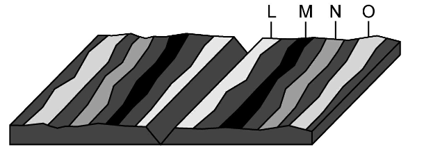
Where would the oldest rock be found?
a)
L
b)
M
c)
N
d)
O
9.
How is it possible for new crust to be formed without increasing the surface area of the Earth?
a)
Crust is destroyed at the same time it is created
b)
New crust is underwater where it sinks
c)
New crust breaks more easily than old crust
10.
The Great Rift Valley in Africa and the Mid-Ocean Ridge were all created by this boundary
a)
Divergent
b)
Convergent
c)
Reform
d)
Transform
11.
What are the two types of crust
a)
continental and oceanic
b)
ocean and upper
c)
lower and upper
d)
pizza and subway
12.
subduction zones in the ocean can create which features?
a)
islands
b)
volcanoes
c)
earthquakes
d)
all of the above
13.
When an oceanic plate and a continental plate collide, which one will subduct?
a)
oceanic
b)
continental
c)
neither
14.
This landform can occur at a divergent plate boundary.
a)
ocean trench
b)
mid-ocean ridge
c)
tall mountains
d)
transform fault
15.
Scientists use ______ to determine the oceans depth.
a)
Submarine
b)
Sonar
c)
Helicopter
d)
Light
16.
The _________ is the gradually sloping end of a continent that extends under the ocean to 350 m deep.
a)
continental shelf
b)
trench
c)
seamount
d)
abbysal plain
17.
What is a deep, steep-sided canyon in the ocean floor?
a)
seamount
b)
trench
c)
continental rise
d)
continental slope
18.

What is label B
a)
Trench
b)
Mid ocean ridge
c)
Seamount
d)
Abyssal plain
19.

Label A
a)
continental slope
b)
continental shelf
c)
abyssal plain
d)
sea mount
20.

Label C
a)
continental slope
b)
continental shelf
c)
abyssal plain
d)
sea mount
21.

What happens at D
a)
continental slope
b)
continental shelf
c)
seafloor spreading
d)
sea mount
22.
the deep flat land of the ocean floor
a)
abyssal plain
b)
rift
23.
A __________ is the area in an ocean basin where new ocean floor is formed
a)
sea mount
b)
continental shelf
c)
mid ocean ridge
d)
continental slope
24.
Seamount is similiar to...
a)
a volcanic island
b)
a small mountain or volcano
c)
The Great Plains
d)
The Grand Canyon
25.
If a marine scientist wanted to study the depth of the ocean at a particular point, what is the best method for them?
a)
Side Scan Sonar
b)
Multibeam Sonar
c)
Plumb line
d)
Satellite
26.
How much wider is the Atlantic Ocean getting each year?
a)
Approximately 20 mm/year
b)
Approximately 40 mm/year
c)
Approximately 100 mm/year
d)
Approximately 3 mm/year
27.
About how many times has the Earth reversed its polarity in the last 20 million years?
a)
2
b)
60
c)
200
d)
17
28.

This map represent the _________________ of the ocean floor.
a)
Ages
b)
Elevations
c)
Depths
d)
Sand colors
29.

This type of map is called what?
a)
A topographic map
b)
A bathymetric map
c)
An oceanic map
d)
A mercator map
Reset

