Wayground logo

Free Printable Worksheets

Font size

S
M
L
XL
Worksheets

Freshwater Review

Total questions: 30

Worksheet time: 23mins

Name
Class
Date
1.

Approximately what percentage of Earth's water is SALTwater?

a)

97 %

b)

71%

c)

30%

d)

3%

2.
A stream that runs into a river is known as a
a)
Porosity
b)
Tributary
c)
Stream Run
d)
Runoff
3.

The land area that supplies water to a river basin is called a

a)

water table

b)

trailer

c)

house

d)

watershed

4.
What caused tributaries to flow downward toward a main river?
a)
friction
b)
surface tension
c)
gravity
d)
silt and sand
5.

Streams, rivers, and lakes are examples of...

a)

surface water

b)

ground water

c)

aquifers

d)

water tables

6.
About this much of Earth is covered in water...
a)
3%
b)
50%
c)
70%
d)
90%
7.
Able to allow water to pass through
a)
Permeability
b)
Runoff
c)
Pores
d)
Permeable
8.
A hole dug into an aquifer to reach groundwater is called... 
a)
an aquitard/aquiclude
b)
a well
c)
a recharge zone
d)
a water table
9.
An underground layer of rock or sediment that holds water?
a)
Reservoir
b)
Aquifer
c)
Groundwater
d)
Watershed
10.
Water stored below the Earth's surface is called:
a)
Groundwater
b)
Bogs
c)
Water in the ground
11.

How much of Earth's water is FRESHwater?

a)

75%

b)

3%

c)

97%

d)

66%

12.
2/3 of freshwater on Earth is "locked away" in what water source location?
a)
atmosphere
b)
rivers and lakes
c)
underground
d)
ice and glaciers
13.
The ability of a liquid to flow through a substance is:
a)
Porosity
b)
Permeability
14.
A substance has a low permeability when:
a)
Water can flow through easily
b)
Water CAN'T Flow through easily
15.
An aquifer is a(n)
a)
well in which water rises because of pressure
b)
underground layer of rock or sediment that holds water
c)
type of hot spring from which the water periodically erupts
d)
place where groundwater bubbles or flows out of cracks in the rock
16.

How many river basins are in North Carolina?

a)

11

b)

17

c)

30

d)

100

17.

The drainage area of a river is called a ___________?

a)

Estruary

b)

River Basin

c)

Ocean

d)

Beach

18.
Drainage area of a river.
a)
River basin
b)
Groundwater
c)
Estuary
d)
Watershed
19.
The water found in cracks and pores in sand, gravel and rocks below the earth’s surface.
a)
Groundwater
b)
Watershed
c)
Estuary
d)
Ocean
20.
Pertaining to the edges of streams or rivers.
a)
Riparian
b)
Aquifer
c)
Vegetation
d)
Ocean
21.
What is the relationship between groundwater and surface water?
a)
Surface water percolates (moves) through the soil to form groundwater.
b)
There is no relationship between surface and groundwater.
c)
Groundwater filters through the soil to form surface water.
d)
Surface water is found in lakes directly above underground water sources.
22.

How do aquifers get recharged/ refilled?

a)

Runoff into the ocean

b)

Precipitation that infiltrates all over

c)

Polar ice caps melting

d)

Precipitation that percolates down through the soil

23.
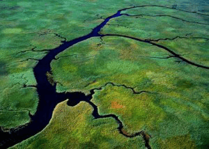
What does this image show?
a)
Headwaters
b)
Meander
c)
Levee
d)
River Mouth
24.

A stream or river that joins the main river is:

a)

A tributary

b)

A confluence

c)

The mouth

d)

A Canyon

25.
A ___________ is made of smaller tributaries and the bigger rivers they flow into.
a)
Tributaries
b)
River System
c)
Watershed
d)
Runoff
26.

What is a watershed?

a)

Land that collects and channels water from a small body of water to a larger body of water

b)

the shape of the land determined by elevation

c)

A natural stream of water of considerable volume

d)

a river and all its tributaries

27.
The name of the area that is the upper level of the zone of saturation:
a)
Zone of Saturation
b)
Zone of Aeration
c)
Water Table
28.
Which of the following does not affect permeability?
a)
the amount of space between particles
b)
how much rainfall falls in a year
c)
the size of the particles that make up the ground
d)
how much the particles are able to absorb
29.

What percentage of the Earth’s water is usable fresh water?

a)

<1%

b)

3%

c)

30%

d)

97%

30.

People can access water by drilling a well into a/an _______.

a)

reservoir

b)

aquifer

c)

meander

d)

delta