wayground logo

Free Printable Worksheets

NEW

Font size

S
M
L
XL
Worksheets

Continents & Oceans

Total questions: 34

Worksheet time: 26mins

Name
Class
Date
1.
What is the continent that is pink?
a)
North America
b)
South America
c)
Asia
d)
Australia
2.
What is the continent that is blue?
a)
Africa
b)
Australia
c)
Antarctica
d)
Asia
3.
What is the continent that is red?
a)
North America
b)
Europe
c)
Africa
d)
Australia
4.
What is the continent that is dark green?
a)
North America
b)
South America
c)
Europe
d)
Australia
5.
What is the continent that is yellow?
a)
Africa
b)
Australia
c)
Asia
d)
Antarctica
6.
What is the continent that is orange?
a)
Africa
b)
Australia
c)
Antarctica
d)
Asia
7.
What is the continent that is light green?
a)
North America
b)
South America
c)
Africa
d)
Australia
8.
How many continents are there in the world?
a)
4
b)
5
c)
6
d)
7
9.
How many oceans are there in the world?
a)
7
b)
6
c)
5
d)
4
10.
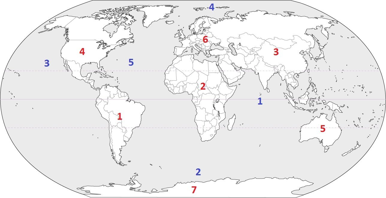
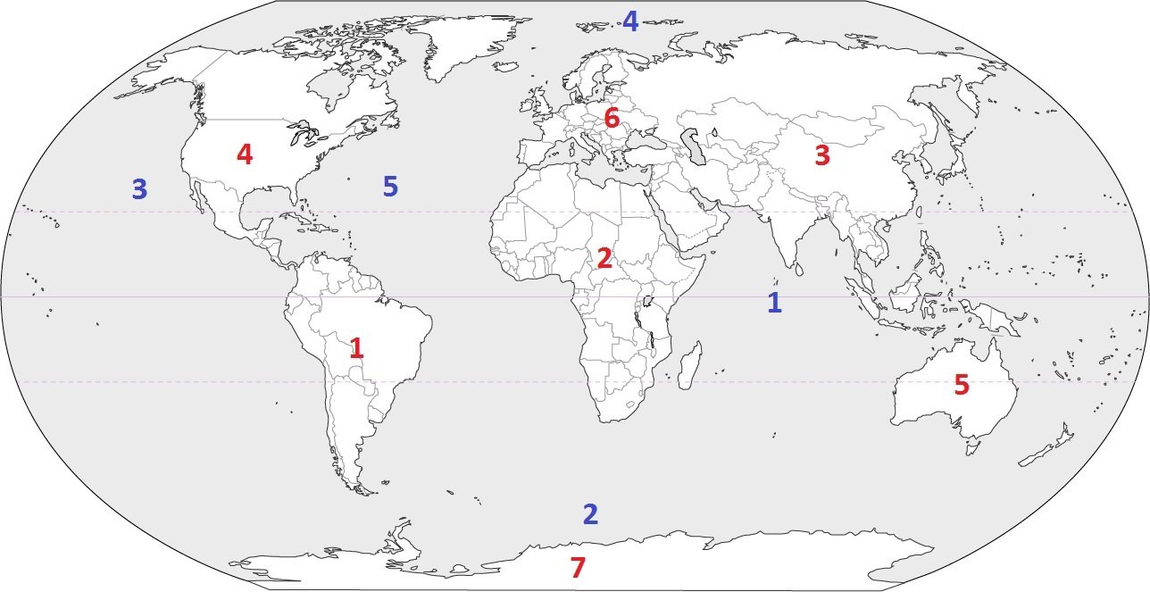
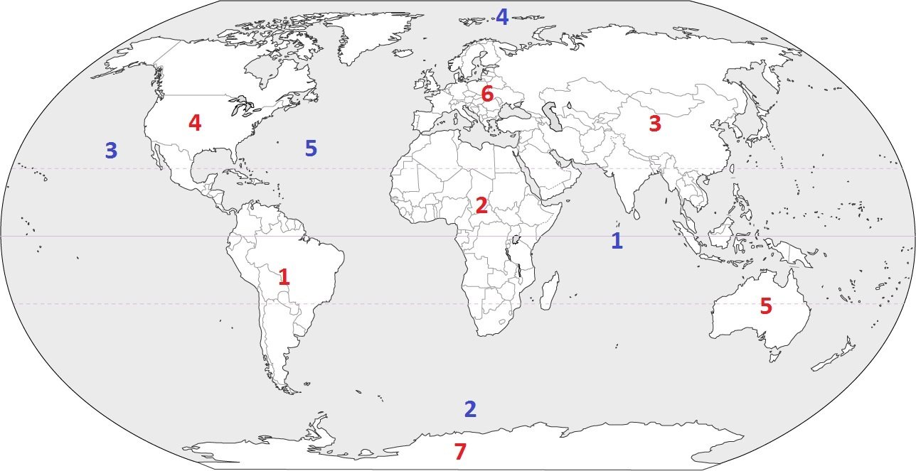
Which continent is located at #3?
a)
Australia
b)
Asia
c)
Europe
d)
South America
11.
Which continent is located at #5?
a)
South America
b)
Asia
c)
Australia
d)
Antarctica
12.
Which continent is located at #7?
a)
Asia
b)
Africa
c)
Australia
d)
Antarctica
13.
Which continent is located at #4?
a)
South America
b)
North America
c)
Europe
d)
Africa
14.
Which continent is located at #1?
a)
North America
b)
Antarctica
c)
South America
d)
Asia
15.
Which continent is located at #6?
a)
Asia
b)
Europe
c)
Africa
d)
Antarctica
16.
Which continent is located at #2?
a)
Africa
b)
South America
c)
Australia
d)
Europe
17.
Which is the largest continent in the world?
a)
Asia
b)
Africa
c)
North America
d)
Antarctica
18.
Which continent is home of the Sahara Desert and is considered the hottest?
a)
South America
b)
Europe
c)
Africa
d)
Australia
19.
On this continent, you can find animal species such as penguins, seals and some birds. This is the coldest continent.
a)
North America
b)
Antarctica
c)
South America
d)
Europe
20.
Identify the ocean at location #3
a)
Atlantic Ocean
b)
Arctic Ocean
c)
Pacific Ocean
d)
Indian Ocean
21.
Identify the ocean at location #5
a)
Atlantic Ocean
b)
Southern Ocean
c)
Pacific Ocean
d)
Arctic Ocean
22.
Identify the ocean at location #2
a)
Indian Ocean
b)
Pacific Ocean
c)
Southern Ocean
d)
Arctic Ocean
23.
Identify the ocean at location #1
a)
Southern Ocean
b)
Arctic Ocean
c)
Atlantic Ocean
d)
Indian Ocean
24.
Identify the ocean at location #4
a)
Indian Ocean
b)
Pacific Ocean
c)
Arctic Ocean
d)
Atlantic Ocean
25.

What part of a map explains symbols and colors used on the map?

a)

map key

b)

scale bar

c)

compass rose

d)

map grid

26.

What part of a map identifies which way is North, South, East, and West?

a)

map key

b)

scale bar

c)

compass rose

d)

map grid

27.
What is this object known as?
a)
map symbol
b)
map key
c)
map scale
d)
compass rose
28.

The equator and the prime meridian divide Earth into halves. What are these halves called?

a)

hemispheres

b)

symbols

c)

atlas

29.

___ is a line drawn from the North Pole to the South Pole that passes through Europe and Africa.

a)

globe

b)

hemisphere

c)

prime meridian

30.

What is a line drawn around the Earth halfway between the North Pole and the South Pole?

a)

hemisphere

b)

equator

c)

prime meridian

31.

What do you call a small round model of Earth that you can hold or touch with your hands?

a)

globe

b)

equator

c)

prime meridian

32.

A good place to look for political and physical maps is an ___. This is a collection or books of maps.

a)

title

b)

atlas

c)

legend

33.
An imaginary line that divides the northern and southern hemispheres is the.....
a)
Prime Meridian
b)
longitude
c)
equator
d)
latitude
34.
An imaginary line that divides the eastern and western hemispheres?
a)
equator
b)
longitude
c)
latitude
d)
prime meridian