wayground logo

Free Printable Worksheets

NEW

Font size

S
M
L
XL
Worksheets

APHG Unit 1 and 2 Review

Total questions: 70

Worksheet time: 43mins

Name
Class
Date
1.

What’s region?

a)

A piece of land

b)

A place where people live

c)

A grupo of places that have common traits

d)

A group of countries

2.

What CONTINENT is this?

a)

North America

b)

South America

c)

Europe

d)

Australia

3.

What CONTINENT is this?

a)

Africa

b)

Europe

c)

Asia

d)

Antarctica

4.

What CONTINENT is this?

a)

North America

b)

Australia

c)

South America

d)

Africa

5.

What CONTINENT is this?

a)

Africa

b)

Australia

c)

Asia

d)

Europe

6.

What CONTINENT is this?

a)

South America

b)

Antarctica

c)

Africa

d)

The Arctic

7.

What CONTINENT is this?

a)

New Zealand

b)

Australia

c)

Asia

d)

North America

8.

What OCEAN is this?

a)

Atlantic

b)

Indian

c)

Pacific

d)

Arctic

9.

What OCEAN is this?

a)

Atlantic

b)

Indian

c)

Pacific

d)

Arctic

10.
a)

Regional Scale

b)

National Scale

c)

Local Scale

d)

Global Scale

11.
a)

Regional Scale

b)

Local Scale

c)

National Scale

d)

Global Scale

12.
a)

Regional Scale

b)

National Scale

c)

Local Scale

d)

Global Scale

13.

Newspaper routes for the city of Washington D.C.

a)

Local Scale

b)

Regional Scale

c)

National Scale

d)

Global Scale

14.
The location of a place using the latitude-longitude grid is called: 
a)
A.  referenced location 
b)
A.  central location
c)
A.  relative location
d)
A.  absolute location 
15.
The location of a place in relationship to other places or features around it is called: 
a)
absolute location
b)
relative location
c)
site
d)
situation
16.
Scale is…                                     
a)
the system used by geographers to transfer locations  from a globe to a map
b)
the extent of spread of a phenomenon over a given area
c)
 the difference in elevation between two points in an area
d)
 the relationship between the length of an object on a map and that feature on the landscape
17.
The physical qualities of the original location for a city is referred to as the
a)
site
b)
situation
c)
relative location
d)
absolute location
18.
The process of the spread of an idea and/or dissemination of an innovation from its source area to other cultures, is the process of cultural: 
a)
diffusion
b)
simultaion
c)
adaptation
d)
movement
19.
The layering of geographic data by computers into data sets is known as: 
a)
GPS
b)
GIS
c)
ENSO
d)
OPEC
20.
Geographers usually categorize cultural diffusion into the two broad categories of 
a)
 Expansion and hierarchical
b)
Contagious and stimulus
c)
 Expansion and relocation
d)
 Migrant and hierarchical
21.
The visible imprint put on the environment by people is called?
a)
Cultural Landscape
b)
Place
c)
Location
d)
Human Environment Interaction
22.
What is it called when you take a 3D image and put it onto a 2D surface?
a)
Cartogram
b)
Projection
c)
Globe
d)
Instagram
23.
Asking the question "why is something found in a particular place", is using which theme of geography?
a)
Place
b)
Movement
c)
Human Environment Interaction
d)
Location
24.
Geographers group like things together into regions in order to make them easier to study.  What type of region would a corn field be?
a)
Perceptual
b)
Formal
c)
Functional
d)
Vernacular
25.
Measuring the distance people are willing to travel to shop at a store would be creating what type of region for that store?
a)
Formal
b)
Perceptual
c)
Functional
d)
Uniform
26.
The imprint that humans leave, such as buildings, roads, cemeteries, etc. are all considered to be part of the:
a)
Location
b)
Region
c)
Cultural Landscape
d)
Move
27.
Billy thinks that in the south, everyone eats grits, eats fried chicken and watches football.  He would be creating what type of region of the south with these ideas?
a)
Formal
b)
Functional
c)
Perceptual
d)
Uniform
28.
Which of the following divides Earth into Eastern and Western Hemispheres?
a)
Prime Meridian
b)
Hemisphere Line
c)
Equator
d)
Tropic of Capricorn
29.
Which type of map would show the boundaries of countries?
a)
vegetation map
b)
political map
c)
land-use map
d)
elevation map
30.
What is remote sensing?
a)
analyzing different types of data
b)
tracking changes on Earth's surface
c)
using software to combine data
d)
getting information from far away
31.
Which of the following shows places on the Earth's surface the most accurately?
a)
thematic maps
b)
globes
c)
general-purpose maps
d)
physical maps
32.
Imaginary North-South line that passes through Greenwich, England, and has a value of 0 degrees
a)
latitude
b)
longitude
c)
relief
d)
scale
33.
Environment influences, but does not strictly determine, how a culture interacts with the environment.
a)
Environmental Determinism
b)
Environmental Possibilism
c)
Cultural Determinism
d)
Cultural Environmentalism
34.
The physical environment causes social and cultural development.
a)
Cultural Environmentalism
b)
Environmental Possibilism
c)
Environmental Determinism
d)
Cultural Possibilism
35.
made up of a central place and surrounding areas affected by it. Often, this is a metropolitan area that consists of a major city and lots of smaller towns or cities that surround it.
a)
functional region
b)
perceptual region
c)
cultural landscape
d)
free enterprise
36.
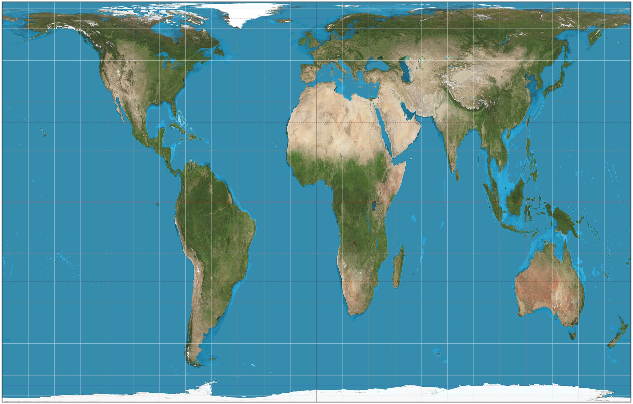
Which projection is this?
a)
Peter's
b)
Robinson
c)
Mercator
d)
Goode's
37.
Which projection is this?
a)
Lambert
b)
Mercator
c)
Goode's Homolosine
d)
Robinson
38.
Which projection is this?
a)
Robinson
b)
Mercator
c)
Eckert IV
d)
Goode's Homolosine
39.
Which map projection makes land near the poles seem gigantic (like Antarctica and Greenland)?
a)
Lambert
b)
Mercator
c)
Robinson
d)
Eckert IV
40.
Which projection is this?
a)
Lambert
b)
Mercator
c)
Goode's Homolosine
d)
Robinson
41.
Type of Map?
a)
Topographic
b)
Weather
c)
Thematic
d)
Choropleth
42.
This is what type of map?
a)
Mercator
b)
Robinson
c)
Cartogram
d)
Homoloseine
43.
This is what type of map?
a)
Cartogram
b)
Dot
c)
Choropleth
d)
Political
44.

Which stage of the Demographic Transition Model do demographers agree most of Europe is in?

a)

Stage 1

b)

Stage 2

c)

Stage 3

d)

Stage 4

45.

The Dust Bowl in the Great Plains is the best example of which push or pull factor?

a)

Political pull factor

b)

Economic push factor

c)

Environmental push factor

d)

Economic pull factor

46.
The portion of the Earth’s surface occupied by permanent human settlement is called _______________.
a)
Arable land
b)
Occupied land
c)
Ecumene
d)
Megalopolis
47.

Comparing the charts, maps, and other data on the world population growth in this chapter, one can deduce that after the Ice Age, approximately 10,000 years ago Earth's human population...

a)

changed little because of the availability of food from massive land animals.

b)

began a long period of near stagnation, following a heretofore unprecedented period of rapid growth.

c)

had not yet appeared on the surface of the planet.

d)

began to increase at a heretofore unprecedented rate, following millennia of near stagnation.

e)

increased at unprecedented rates for two centuries, then declined again.

48.

Land suited for agriculture is called...

a)

popuolation density

b)

agricultural density

c)

physiological land

d)

arid land

e)

arable land

49.

What significant population problem does the United States, as well as other MDCs, face?

a)

High infant mortality rate

b)

High CDR

c)

High CBR

d)

An aging population

50.

Immigrants to the United States since 1960 have come increasingly from

a)

Eastern and Southern Europe

b)

Sub-Saharan Africa and South Asia

c)

Northern and Western Europe

d)

Asia and Latin America

51.

According to the 1986 Immigration Reform and Control Act, undocumented immigrants were

a)

no longer eligible for public services in the US

b)

increasingly deported if caught

c)

permitted to become legal residents

d)

denied voting rights in the US

52.
Which of the following is NOT one of the four major population concentrations found on the Earth?
a)
Southeast Asia
b)
West Africa
c)
Europe
d)
South Asia
53.
total population / total land area = _______
This is the formula for which of the following?  
a)
arithmetic population density
b)
physiological population density
c)
agricultural population density
54.

Which of the following is the BEST definition of the term crude birth rate?

a)

The total number of births in a year

b)

The number of births in a year divided by 1000

c)

The average number of births per 1000 people

d)

The total number of births per year per 1000 people

55.

Which of the following is the BEST definition of the term crude death rate?

a)

The total number of deaths in a year

b)

The average number of deaths per 1000 people

c)

The total number of deaths per year per 1000 people

d)

The number of deaths in a year divided by 1000

56.
Replacement level, the number of births needed to keep a population at a stable level without immigration, requires a total fertility rate (TFR) of
a)
a) 10
b)
b) 2.1
c)
c) 3.5
d)
d) 5.0
57.
Which region of the world is largely BELOW replacement level?
a)
a) Sub-Saharan Africa
b)
b) South America
c)
c) South Asia
d)
d) Europe
58.
What stage?
-Death rate drops due to medical advances
-Population increases greatly
a)
Stage 1
b)
Stage 2
c)
Stage 3
d)
Stage 4
59.
What stage?
-Birth rate drops due to more urbanization/rising quality of life
-Population continues to rise but slowly
a)
Stage 1
b)
Stage 2
c)
Stage 3
d)
Stage 4
60.
Why does Egypt have a very high physiological density?
a)
very little land is arable
b)
it is a small country
c)
it does not have many people
d)
it has a low carrying capacity
61.
A pronounced gender imbalance is most recognizable in
a)
Denmark
b)
India
c)
Singapore
d)
Japan
62.
What happened in the 1750s that led population growth?
a)
Industrial Revolution
b)
Agricultural Revolution
c)
Neolithic Revolution
d)
2nd Agricultural Revolution
63.
the average number of children per woman
a)
birth rate
b)
fertility rate
c)
family rate
d)
census
64.

Which are needed to figure the demographic equation?

a)

natural increase + net migration

b)

natural increase + age dependency

c)

sex ratio + net migration

d)

total fertility rate + net migration

65.
Canada's projected 2050 population pyramid shows a country in stage ____ of the demographic transition model.
a)
2
b)
3
c)
4
d)
5
66.
This population pyramid shows a ____________ population.
a)
rapidly growing
b)
rapidly declining 
c)
stable
d)
economically thriving
67.

The number of people that are too young or too old to work on a population pyramid.

a)

Sex Ratio

b)

Dependency Ratio

c)

Demographic Ratio

d)

Population Ratio

68.

The Population Pyramid shown is most likely which country?

a)

Canada

b)

Japan

c)

Zimbabwea

d)

Algeria

69.

The population pyramid shown is most likely which country?

a)

Nigeria

b)

China

c)

Germany

d)

Japan

70.

Which stage of the Demographic Transition Model is Chile currently in?

a)

Stage 2

b)

Stage 3

c)

Stage 4

d)

Stage 5