Wayground logo

Free Printable Worksheets

Font size

S
M
L
XL
Worksheets

Review for 8th Science FCAT (Plate Tectonics)

Total questions: 22

Worksheet time: 43mins

Name
Class
Date
1.
What is the name of the single landmass that began to break apart 200 million years ago?
a)
Panthalassa
b)
Laurasia
c)
Gondwanna
d)
Pangaea
2.
The movement of fluid, caused by differences in temperature, that transfers heat from one part of the fluid to another is _____________.
a)
Convection current
b)
Seismic waves
c)
Sea-floor spreading
d)
Conduction current
3.
What is an undersea mountain chain where new ocean floor is produced?
a)
Rift valley
b)
Deep-ocean trench
c)
Mid-ocean ridge
d)
Transform bounda
4.
A __________ is a deep valley along the ocean floor beneath which oceanic crust slowly sinks toward the mantle.
a)
deep-ocean trench
b)
rift valley
c)
sea-floor spreading
d)
mid-ocean ridge
5.
What is the process by which oceanic crust sinks beneath a deep-ocean trench and back into the mantle at a convergent plate boundary?
a)
Subduction
b)
Induction
c)
Abduction 
d)
Reduction
6.
_____________ is a plate boundary where two plates move away from each other.
a)
Convergent boundary
b)
Transform boundary
c)
Divergent boundary
d)
Insurgent boundary
7.
_____________ is when two plates move toward each other.
a)
Convergent boundary
b)
Allegiant boundary
c)
Transform boundary
d)
Sliding boundary
8.
A _____________ is when two plates move past each other in opposite directions.
a)
emergent boundary
b)
divergent boundary
c)
transform boundary
d)
convergent boundary
9.

The movement of the tectonic plates is caused by

a)

the rotation of the Earth.

b)

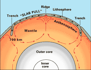
convection currents in the Asthenosphere

c)

the gravity of the iron-nickel core.

d)

the Moho discontinuity.

10.

In some areas of the world, like California and Japan, earthquakes are a common occurrence. How can this best be explained?

a)

The strong ocean currents are undermining both areas causing earthquakes.

b)

Both areas are located near the edge of the Pacific Ocean, the unstable sand causes earthquakes.

c)

Both areas are subjected to strong ocean wind and waves that causes earthquakes.

d)

Both areas are on the boundary of active plates, the motion of the plates causes earthquakes.
11.
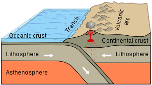
Subduction zones occur on Earth where dense oceanic crust dives under more buoyant continental crust. These boundaries are characterized by a deep ocean trench next to a high continental mountain range, large numbers of earthquakes and volcanoes. All of this is further evidence for the
a)
big bang theory.
b)
theory of plate tectonics.
c)
origin of the species.
d)
theory of natural selection.
12.
There are three types of plate boundaries. Which choice is NOT a type of plate boundary?
a)
convergent
b)
thrust
c)
divergent
d)
transform
13.

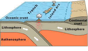
Observe this diagram of a plate boundary. One statement BEST describes what is happening. It is that

a)

the oceanic crust is melting.

b)

the denser ceanic crust is subducting under the less dense oceanic crust

c)

volcanic islands are forming.

d)

the tectonic plates are moving away from each other.
14.

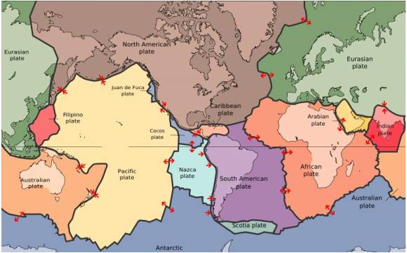
The map in the picture shows tectonic plate boundaries. This map would be useful in predicting the location of future

a)

droughts

b)

hurricanes

c)

earthquakes

d)

tornadoes

15.
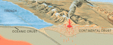
What geological forces might be responsible for this range of mountains?
a)
diverging tectonic plates
b)
erosion of the land by the ocean
c)
converging tectonic plates
d)
deposition of sediments by the ocean
16.

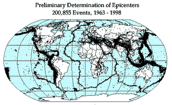
Earthquake epicenters (center of where the earthquakes started) were mapped for a 35 year period in the diagram above. The black dots indicate these epicenters. The black dots appear along what feature on Earth?

a)

hot spots

b)

plate boundaries

c)

rift zones

d)

sea floor spreading

17.
The Earth’s surface is not a solid surface but is divided into
a)
several oceanic plates.
b)
continental and crustal plates.
c)
seven continental plates.
d)
continental and oceanic plates.
18.

The 2004 Indian Ocean tsunami was caused by a shift in two plates that pushed one section of the sea floor under another section of the sea floor by 5 meters. What type of boundary is this?

a)

divergent

b)

convergent

c)

transform

d)

metamorphic

19.
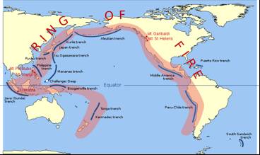
The image shows the Pacific Ring of Fire, a region of high tectonic activity. What evidence supports the theory that the tectonic activity of the region is due to the subduction of tectonic plates?
a)
The region is bound by many oceanic trenches.
b)
North America seems to be colliding with Asia at the north of the ring.
c)
The Asia-Pacific region is dotted by many small and large islands
d)
The landmasses look like they would fit together like the pieces of a jigsaw puzzle.
20.

___________ currents in the Earth's asthenosphere cause plate to shift at their boundaries. This movement also causes earthquakes and volcanic activity.

a)

conduction

b)

convection

c)

radiation

d)

ocean

21.

What is the source of energy that drives plate movement?

a)

the subducton of the sea floor

b)

the different densities of the oceanic and crustal plates

c)

convection currents in the asthenosphere

d)

the friction force between the plates that move past each other

22.

The diagrams shows a stack of rock layers. Layer T contains a well-know index fossils that is 120 million years old. Layer R contains a different index fossil that is 100 million years old. Based on this information and the principle of superposition, how old is Layer M?

a)

either 20 million or 220 milllion years old

b)

between 100 million and 120 million years old

c)

younger than 100 milion years

d)

older than 120 million years