
 Worksheets
Geography
Total questions: 50
Worksheet time: 31mins
Name
Class
Date
1.

Which of the following is a cardinal direction?
a)
northwest
b)
east
c)
southeast
d)
lake
2.

Map scale shows what?
a)
directions
b)
cities
c)
distance
d)
time
3.

We live on which continent?
a)
North America
b)
South America
c)
Europe
d)
Australia
4.

If one inch is equivalent to five miles. How many miles is ten inches?
a)
60
b)
20
c)
50
d)
100
5.

What does a compass rose show?
a)
Key
b)
Distance
c)
Directions
d)
States
6.
Name the imaginary line which divides Northern and Southern hemispheres
a)
Cardinal Direction
b)
South
c)
North
d)
Equator
7.

Which two continents are located entirely in the Western Hemisphere?
a)
Europe and Africa
b)
Asia and Antarctica
c)
North America and Australia
d)
North America and South America
8.

What does a map’s scale compare?
a)
direction on a map with direction on Earth
b)
distance on a map with distance on Earth
c)
location on a map with location on a globe
d)
distortion on a map with distortion on a globe
9.
imaginary line found at zero degrees latitude
a)
Isthmus
b)
Border
c)
Prime Meridian
d)
Equator
10.
the term for one-half of a globe or one-half of the planet Earth
a)
Sphere
b)
Legend
c)
Prime Meridian
d)
Hemisphere
11.
imaginary line found at zero degrees longitude
a)
Prime Meridian
b)
Equator
c)
Longitude
d)
Latitude
12.
a tool on a map that shows cardinal directions and sometimes intermediate directions
a)
Compass Rose
b)
Rose Graph
c)
Legend
d)
Map Key
13.

Latitude and Longitude are measured in ________.
a)
inches
b)
Feet
c)
Degrees
d)
Grams
14.
What are the physical and human features of a location?
a)
perception
b)
place
c)
perspective
d)
landscapes
15.
What are lines on a globe drawn in an east-west direction and measured in degrees?
a)
longitude
b)
latitude
c)
grid
d)
equator
16.
What are lines on a globe drawn in a north-south direction and measured in degrees?
a)
longitude
b)
latitude
c)
grid
d)
prime meridian
17.
What is an imaginary line drawn from the North Pole through Greenwich, England to the South Pole?
a)
longitude
b)
latitude
c)
equator
d)
prime meridian
18.
The study of the people, their environment, and their resources is known as
a)
Biology
b)
Archaeology
c)
Geology
d)
Geography
19.
Using the idea of PLACE, why would a person living in a thick forest most likely live in a home made out of wood?
a)
There is a lot of trees and lumber to build his/her home
b)
Amazon Prime delivers wood houses in two days
c)
Homes made out of bricks would be too expensive
d)
Homes made out of fish would be too smelly
20.
What is movement?
a)
Tells us how people, goods, recourses, and ideas move from one place to another
b)
Tells us what makes an area special and what makes it different from every other area
c)
Tells us ways in which the places in an area are alike.
21.
Cutting down trees to build houses is an example of which?
a)
Location
b)
Place
c)
Human-Environment Interaction
d)
Movement
22.
People leaving their homes in Syria and travelling to Turkey to avoid ISIS is an example of which?
a)
Human-Environment Interaction
b)
Movement
c)
Absolute Location
d)
Relative Location
23.
The fact that Africa is south of Europe is an example of which?
a)
Movement
b)
Absolute Location
c)
Relative Location
d)
Place
24.
The states in the area known as the "Southwest" of the United States are often grouped together because they are very hot and dry desert-like areas.
a)
Region
b)
Location
c)
Human Environment Interaction
d)
Movement
25.
What is the acronym to remember the Five Themes of Geography?
a)
MAD
b)
MRHELP
c)
PIG
d)
COW
26.
Using lines of latitude and longitude to find an exact location is...
a)
Absolute Location
b)
Relative Location
c)
Prime Meridian
d)
Place
27.
Wilson Memorial High School is at 189 Hornet Rd, Fishersville, VA 22939
a)
Absolute Location
b)
Relative Location
c)
Place
d)
Region
28.
Washington D.C. is at 38.8 North Latitude and 77 West Longitude
a)
Relative Location
b)
Place
c)
Absolute Location
d)
Region
29.
Florida has very hot and humid summers.
a)
Location
b)
Place
c)
Region
d)
Movement.
30.
Many species of birds travel south in the winter to be near warmer temperatures and then return north in the spring and summer.
a)
Human Environment Interaction
b)
Movement
c)
Region
d)
Place
31.
The Hoover Dam was built to control flooding in the Southwest United States, however it also provides people in that area with a source of fresh water and electricity.
a)
Human Environment Interaction
b)
Location
c)
Movement
d)
Place
32.
Southwest Asia and North Africa are generally referred to as "The Middle East" because the people there have a shared language, religion and similar cultures.
a)
Region
b)
Location
c)
Place
d)
Human Environment Interaction
33.

Which theme of geography tells your WHERE something is?
a)
Location
b)
Place
c)
HEI
d)
Movement
34.
What are the 5 Themes of Geography?
a)
Region, Human-Environment Interaction, Location, Climate, and Place
b)
Region, Human-Environment Interaction, Movement, Place, and Location
c)
Place, Movement, Location, Region, and Human-Alien Interactions
d)
Absolute Location, Relative Location, Climate, Vegetation, and Movement
35.

A political map shows you.....
a)
politicians in the area
b)
political parties
c)
country boundaries
d)
the states that Trump said voted illegally
36.

Which map would you use if you are not interested in humans, only the shape of the earth through rivers and mountains?
a)
political
b)
physical
c)
road
d)
historical
37.

The Pacific Ocean is located at which #?
a)
9
b)
10
c)
11
d)
12
38.

Asia is located at #?
a)
1
b)
2
c)
3
d)
4
39.

What is the continent that is light green?
a)
North America
b)
South America
c)
Africa
d)
Australia
40.

What is the continent that is yellow?
a)
Africa
b)
Australia
c)
Asia
d)
Antarctica
41.

What is the continent that is dark green?
a)
North America
b)
South America
c)
Europe
d)
Australia
42.

What is the continent that is dark red?
a)
North America
b)
Europe
c)
Africa
d)
Australia
43.

What is the continent that is blue?
a)
Africa
b)
Australia
c)
Antarctica
d)
Asia
44.

What is the continent that is pink?
a)
North America
b)
South America
c)
Asia
d)
Oceania/Australia
45.

Which continent is located at 60° N and 120° E
a)
North America
b)
South America
c)
Asia
d)
Europe
46.
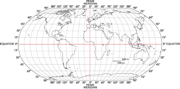
Which continent is located at 30° S and 135° E
a)
North America
b)
Australia
c)
Asia
d)
Europe
47.
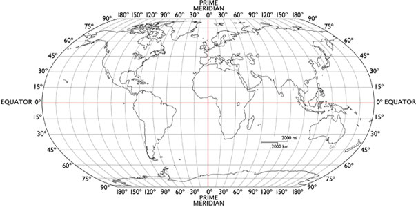
Which continent is located at 60° N and 120° W
a)
North America
b)
South America
c)
Asia
d)
Europe
48.
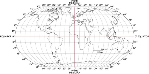
Which continent is located at 0° equator and 60° W
a)
North America
b)
South America
c)
Asia
d)
Europe
49.
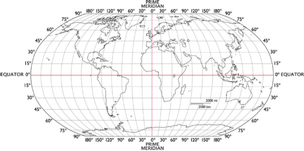
Which continent is located at 45° N and 30° E
a)
North America
b)
South America
c)
Asia
d)
Europe
50.
This type of map depicts features such as mountains, plains, and bodies of water.
a)
Topographic
b)
Resource
c)
Climate
d)
Physical
100 %

