
 Worksheets
Map Skills
Total questions: 27
Worksheet time: 14mins
Name
Class
Date
1.
Measures distance from the equator. These lines run east and west and measure north and south.
a)
Cardinal Directions
b)
Latitude Lines
c)
Longitude Lines
d)
Intermediate Directions
2.
__________ identifies distances on a map. It refers to the relationship (or ratio) between distance on a map and the matching distance on the earth.
a)
Map Scale
b)
Cardinal Directions
c)
Intermediate Directions
d)
Symbols
3.
__________ directions are northeast, southeast, southwest, and northwest.
a)
Latitude
b)
Cardinal
c)
Intermediate
d)
Longitudinal
4.

This type of map shows physical features of the land, including valleys, canyons, plains, and mountains.
a)
Political
b)
Physical
c)
Time Zones
d)
Map Key
5.

A _________ is used to represent real objects on the map such as a building, road, lake, tree, mountain, etc.
a)
Symbol
b)
Compass Rose
c)
Map Scale
d)
Merdian
6.

__________ measures distance from the Prime Meridian. These imaginary lines run from the north pole to the south pole. These lines run north and south and measure east or wes
a)
Latitude
b)
Longitude
c)
Lines
d)
Equator
7.

A __________ is used to identify the direction of north, south, east, and west.
a)
Compass Rose
b)
Map Scale
c)
Latitude Lines
d)
Longitude Lines
8.

The __________ directions are north, east, south, and west.
a)
cardinal
b)
intermediate
c)
map
d)
most imprtant
9.

This type of map shows governmental boundaries of countries, states, and/or counties. It sometimes includes cities, roads, and significant bodies of water.
a)
Physical
b)
Political
c)
Product
d)
Map
10.

A __________ is used to identify what the symbols on the map stand for. The meaning of the symbol may be explained using this.
a)
Physical Map
b)
Map Key
c)
Compass Rose
d)
Map
11.

The red question mark is located to the _________ of the compass rose.
a)
North
b)
South
c)
East
d)
West
12.

The red question mark is located to the _________ of the compass rose.
a)
Northeast
b)
Southeast
c)
Northwest
d)
North
13.

The red question mark is located to the _________ of the compass rose.
a)
Southwest
b)
Southeast
c)
South
d)
West
14.

The red question mark is located to the _________ of the compass rose.
a)
North
b)
Northeast
c)
Northwest
d)
East
15.

The red question mark is located to the _________ of the compass rose.
a)
North
b)
South
c)
Southeast
d)
Southwest
16.
This line measures 0 degrees longitude:
a)
Equator
b)
International Date Line
c)
Meridians
d)
Prime Meridian
17.
The 0 degree line of latitude is the ___________.
a)
Equator
b)
Prime Meridian
c)
International Date Line
d)
Contour line
18.

What is the reason why latitude lines NEVER intersect?
a)
They converge at the poles
b)
They are cool
c)
They are vertical lines
d)
They are parallel
19.

What kind of map is this?
a)
Physical
b)
Political
c)
Globe
20.
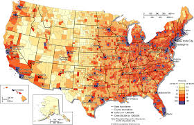
Identify this map.
a)
Population density map
b)
Physical Map
c)
Road map
21.

What type of map is this?
a)
Political
b)
Physical
c)
Economic Activity
22.

This map element tells the purpose of the map
a)
Title
b)
Scale
c)
Legend
d)
Key
23.

What is the map element that tells what symbols on the map mean?
a)
Key/Compass
b)
Key/Legend
c)
Legend/Scale
d)
Inset/Scale
24.

Which map element is a smaller map that shows a "larger" area of land around the map.
a)
Title / Scale
b)
Key / Legend
c)
Inset Map
d)
Compass Rose
25.

This element gives measurements and shows distance between objects on the map
a)
Legend
b)
Key
c)
Title
d)
Scale
26.
Latitude and Longitude are measured in ________.
a)
inches
b)
feet
c)
degrees
d)
grams
27.
Relative location is...
a)
how to get to a place
b)
finding the location of a place by describing its location from another place
c)
not a real thing
d)
exactly where something is located
100 %

