Wayground logo

Free Printable Worksheets

Font size

S
M
L
XL
Worksheets

6th grade 5 themes of geo

Total questions: 73

Worksheet time: 3hrs 37mins

Name
Class
Date
1.
The Five Themes of Geography are the Following:
a)
Place, Region, Interaction, Land-forms, Movement
b)
Place, Region, Interaction, Location, Movement
c)
People, Race, Interaction, Location Movement
d)
Power, Region, Interaction, Location Movement
2.
The picture best represents which of the following?
a)
Movement pull factor
b)
Physical place
c)
Human Environmental Interaction
3.
The picture best represents which of the following?
a)
Movement push factor
b)
Absolute Location
c)
Human Environmental Interaction good
4.
This picture best represents which of the following?
a)
Movement
b)
Place
c)
Relative Location
5.
What is a question geographers ask?
a)
Where is it?
b)
What time is it?
c)
When did it happen?
d)
Why did it happen
6.
The equator divides the earth into what hemispheres?
a)
Southern and Eastern Hemispheres
b)
Eastern and Western Hemispheres
c)
Northern and Western Hemispheres
d)
Northern and Southern hemispheres
7.
The study of people and places on earth is called?
a)
Erosion 
b)
tectonic plates
c)
geography
d)
geometry
8.
What is a region?
a)
an object that shows exact location
b)
an area that is defined by certain features
c)
an area where most things are different?
d)
an area that does not change over time
9.
True or False: The Appalachian Mountains were formed by humans traveling over them.
a)
true
b)
false
10.
An examples of a natural resource is
a)
plastic and buildings
b)
water, fish, trees
c)
glass, chemicals
d)
fire, cans
11.
Absolute location is
a)
the specific address of a place
b)
where something is in relation to another place
c)
talking about if something is close to a restaurant or school
d)
how far something is from a landmark
12.
What does a compass rose tell you on a map?
a)
what the symbols mean
b)
lines of latitude and longitude
c)
directions such as north, east, south, west
d)
the roads on a map
13.
Examples of human characteristics:
a)
trees, mountains
b)
river, lakes
c)
buildings, bridges, roads
d)
desert, snow
14.
Examples of physical characteristics
a)
mountains, lakes, rivers
b)
white house, mount rushmore
c)
schools, resturants
d)
factory, bridges
15.
Why did large cities grow along rivers?
a)
provides land for houses
b)
because they like water
c)
provides water for drinking and farming, and could transport good on river
d)
that's where they first landed when they came to America
16.
What are the 5 themes of geography?
a)
movement, history, region, location, place
b)
movement, region, human/interaction, location, place
c)
geology, human/interaction, location, place, latitude
d)
region, place, longitude, geography, movement
17.

Place and Location are two of the five _______ of Geography.

a)

Units

b)

Characteristics

c)

Themes

d)

Mr. Lips

18.

If we buy clothes from China, what kind of movement is it?

a)

People

b)

Goods

c)

Ideas

d)

The Floss

19.

Geography studies how __________ interact with their environment.

a)

Cats

b)

Factories

c)

Cars

d)

Humans

20.

Which of these moves through the internet?

a)

People

b)

Ideas

c)

Memes

d)

Location

21.

The area that has a feature that makes it different from surrounding areas is called what?

a)

Busch Gardens

b)

Place

c)

Location

d)

Region

22.

What is the purpose of Geography?

a)

To look at cool mountains

b)

To study maps

c)

To describe the Earth as a physical object and a human place

d)

To torture 5th graders

23.

Are you going to study for your test tonight?

a)

Yes, because I want to be ready!

b)

Aw man, studying?

c)

No, I'm going to play Fortnite.

d)

What's studying?

24.
These are features made by man.  (Examples:  schools, lighthouses, pier, fountains)
a)
physical
b)
place
c)
human
d)
location
25.
These are features that occur naturally.  (Examples: rivers, lakes, dunes, mountains)
a)
human-environment interaction
b)
physical
c)
human
d)
region
26.
The pattern of weather in a place over many years is called
a)
environment
b)
climate
c)
precipitation
d)
horizon
27.
Which of the following is the  imaginary line found at zero degrees latitude?
a)
Isthmus
b)
Border
c)
Prime Meridian
d)
Equator
28.
Name the Five Themes of Geography
a)
Movement, Region, HEI, Location, Place
b)
Ask, Acquire, Analyze, Organize, Answer
c)
Global, Inter-regional, Regional, Local, Cities
d)
none of the above
29.
What are the two major parts of geogrpahy?
a)
Physical and Human Geography
b)
Physical and Natural Geography
c)
Maps and Globes
d)
Spatial Scales and The Five Themes of Geography.
30.
Which of The Five Themes of Geography does this statement describe: "How people shape, change, and depend on the environment."
a)
Location
b)
Place
c)
HEI
d)
Movement
31.
Which themes describes how humans change a particular place?
a)
Location
b)
Place
c)
Human-Environment Interaction
d)
Movement
32.

Which theme of geography am I referring to when I say: "Arkansas is located south of Missouri"?

a)

Place

b)

Region

c)

Movement

d)

Location

33.
When we say we live in the South where more days and sunny and warm, we are describing our:
a)
Place
b)
Movement
c)
Region
d)
Location
34.
Which theme is represented in the following image?
a)
Region
b)
Place
c)
Human/ Environment Interaction
d)
Movement
35.
When humans change the environment, we are doing which type of Human/Environment Interaction?
a)
Depend
b)
Adapt
c)
Modify
36.

Which theme is the following an example of?

a)

Place

b)

Region

c)

Location

d)

Movement

37.
What type of movement is being illustrated in the following images?
a)
These images do not show movement
b)
Human
c)
Goods
d)
Ideas
38.
Which theme groups areas by similiar characteristics?
a)
Place
b)
Movement
c)
Region
d)
Human/ Environment Interaction
39.
Bill moved to a beach house in Florida.  His new house is on stilts so that when it floods, the water will not damage the house.  This is an example of which type of Human/ Environment Interaction?
a)
Depend
b)
Adapt
c)
Modify
40.
Which type of human/ environment interaction is represented in the following statement?
a)
Depend
b)
Adapt
c)
Modify
41.
Social media is one way that we...
a)
use GPS
b)
understand the unique characteristics of an area
c)
spread ideas around the world
42.
A climate map is one way to show areas with similar characteristics.  This represents which of the five themes?
a)
Location
b)
Region
c)
Place
d)
Human/ Environment
43.
A general location of one place to another described with direction or distance words is...
a)
absolute location
b)
relative location
44.
Which theme includes how humans adapt, modify or depend on the environment?
a)
movement
b)
place
c)
region
d)
human environment interaction
45.
What hemisphere do you live in?
a)
Canadian
b)
Northern
c)
Southern
d)
Mexican
46.
What Continent do you live on?
a)
South America
b)
Europe
c)
North America
d)
Australia
47.
The four main points of the compass North, South, East, and West.
a)
Compass Rose
b)
Cardinal Directions
c)
Intermediate Directions
d)
Map Scale
48.
This type of map shows physical features of the land, including valleys, canyons, plains, and mountains.
a)
Political
b)
Physical
c)
Time Zones
d)
Map Key
49.
 A __________ is used to identify the direction of north, south, east, and west.
a)
Compass Rose
b)
Map Scale
c)
Latitude Lines
d)
Longitude Lines
50.
__________ measures distance from the Prime Meridian.  These imaginary lines run from the north pole to the south pole.  These lines run north and south and measure east or wes
a)
Latitude 
b)
Longitude
c)
Lines
d)
Equator
51.
 This type of map shows governmental boundaries of countries, states, and/or counties.  It sometimes includes cities, roads, and significant bodies of water.
a)
Physical
b)
Political
c)
Product
d)
Map
52.
 A __________ is used to identify what the symbols on the map stand for.  The meaning of the symbol may be explained using this.
a)
Physical Map
b)
Map Key
c)
Compass Rose
d)
Map
53.
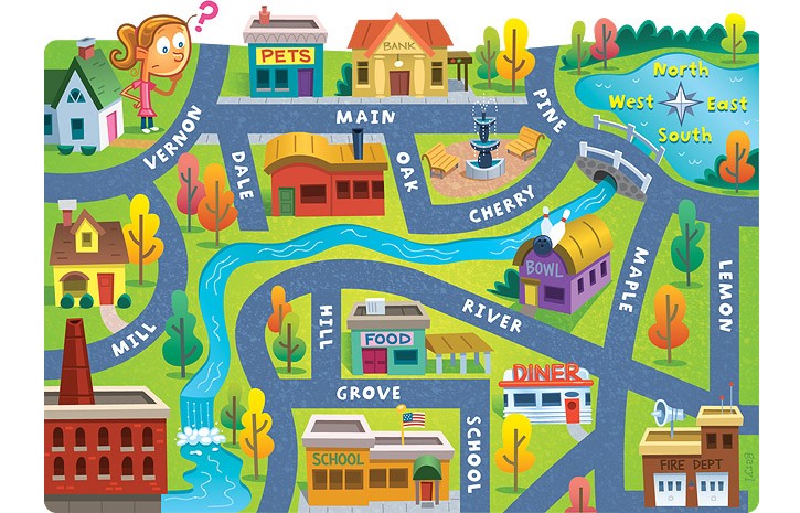
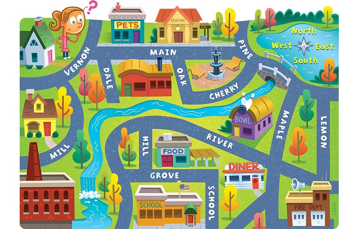
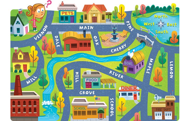
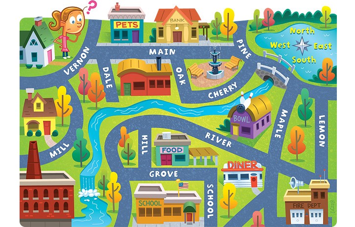
 The red question mark is located to the _________ of the compass rose.
a)
Northeast
b)
Southeast
c)
Northwest
d)
North
54.
What type of map is this?
a)
Political
b)
Physical 
c)
Economic Activity
d)
Population
55.
What type of map is this?
a)
Population 
b)
Physical
c)
Political
d)
Climate 
56.
Lake Plains are _____ of the Appalachian Plateaus.
a)
Southwest
b)
Northwest
c)
Northeast
d)
Southeast
57.
Relative location is...
a)
how to get to a place
b)
finding the location of a place by describing its location from another place
c)
not a real thing
d)
exactly where something is located
58.
This type of map shows kinds of land and bodies of water
a)
Physical map
b)
political map
c)
historical map
59.
The closer you are to the Equator, the _________ it is.
a)
colder
b)
hotter
c)
longer
60.
The school is ____ of the pet store.
a)
North
b)
South
c)
East
d)
West
61.
The fire dept. is ______ of the school.
a)
South
b)
East
c)
North
d)
West
62.
The bank is ____ of the pet store.
a)
East
b)
North
c)
West
d)
South
63.
Lemon street runs _____________.
a)
East and West
b)
North and South
c)
South and West
d)
North and East
64.
Continent F is ________.
a)
Antarctica
b)
Australia
c)
Europe
d)
North America
65.
Name Continent C!
a)
Antarctica
b)
Europe
c)
Asia
d)
North America
66.
Continent G is ________.
a)
Asia
b)
Antarctica
c)
North America
d)
Europe
67.
Name Ocean #1!
a)
Indian
b)
Pacific
c)
Atlantic
d)
Southern
68.
Ocean #4 is ________.
a)
Indian
b)
Atlantic
c)
Pacific
d)
Southern
69.
Which continent is touched by the Prime Meridian?
a)
North America
b)
Africa
c)
Australia
70.
A _______________ is exactly half of the earth.
a)
Equator
b)
Hemisphere
c)
Tropic of Cancer
d)
Arctic Circle
71.

On the following map, what do the grey triangles represent?

a)

Sources of fuel

b)

Gold mines

c)

Areas where precious gems can be found

d)

Areas where nonmetals can be found

72.

On the map the circles, triangles, and squares are all examples of:

a)

Legends

b)

Keys

c)

Roses

d)

Symbols

73.
This element gives measurements  and shows distance between objects on the map
a)
Legend
b)
Key
c)
Title
d)
Scale