
 Worksheets
Geogrpahy Review
Total questions: 31
Worksheet time: 28mins
Name
Class
Date
1.
What is the name of the symbol that shows cardinal and intermediate directions?
a)
Key
b)
Scale
c)
Title
d)
Compass Rose
2.
On a map, what shows the relationship between actual distance and distance shown on a map?
a)
Map Key
b)
Map Scale
c)
Symbol
d)
Compass Rose
3.
What kind of map would you use to find mountain ranges?
a)
Political
b)
Population
c)
Physical
d)
Climate
4.

What is geography?
a)
the study of Earth
b)
the study of fossils
c)
the study of people
d)
the study of history
5.

Which of the following is a cardinal direction?
a)
northwest
b)
east
c)
southeast
d)
lake
6.

Map scale shows what?
a)
directions
b)
cities
c)
distance
d)
time
7.

We live on which continent?
a)
North America
b)
South America
c)
Europe
d)
Australia
8.

An atlas is a book of what?
a)
maps
b)
people
c)
bodies of water
d)
regions
9.

What is the continent that is yellow?
a)
Africa
b)
Australia
c)
Asia
d)
Antarctica
10.

What is the continent that is dark green?
a)
North America
b)
South America
c)
Europe
d)
Australia
11.

These lines run east and west but the measure distances of the earth north and south of the equator.
a)
longitude
b)
latitude
c)
equator
d)
location
12.
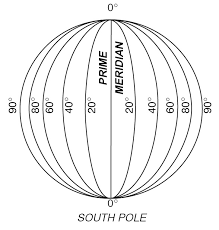
These lines run north and south but they measure distances of the earth east and west of the Prime Meridian.
a)
longitude
b)
latitude
c)
equator
d)
location
13.

Which continent is EAST of Europe?
a)
North America
b)
Africa
c)
Antarctica
d)
Asia
14.
A map showing boundaries of countries is what type of map?
a)
Political
b)
Physical
c)
Thematic
d)
Nothing
15.
A map showing bodies of water, lakes, and islands is what type of map?
a)
Political
b)
Physical
c)
Thematic
d)
Nothing
16.
A _____ tells us what the map is about.
a)
Summary
b)
Story
c)
Title
d)
Conclusion
17.

Type of Map?
a)
Weather
b)
Australian
c)
Choropleth
d)
Political
18.
What map would you use to locate the largest body of fresh water in the world?
a)
Political
b)
Physical
c)
Resource
d)
Road
19.
What does "geo" mean?
a)
earth
b)
water
c)
stone
d)
None of these
20.
The change in shape, size, or location of a place when shown on a map.
a)
Map Projection
b)
Distortion
21.
A way of representing the spherical Earth on a flat surface.
a)
Map Projection
b)
Distortion
22.
All map projections are somehow incorrect.
a)
True
b)
False
23.

What is the name of this line at 0 degrees latitude?
a)
Prime Meridian
b)
Equator
c)
North Pole
d)
South Pole
24.

What is the name of the line at zero degrees longitude?
a)
Equator
b)
Prime Meridian
c)
North Pole
d)
South Pole
25.

What is the approximate location of letter B?
a)
80oN, 0o
b)
0o, 80oW
c)
80oS, 0o
d)
0o, 80oE
26.

a)
The map show the lines of longitude.
b)
The map shows the lines of latitude.
27.

a)
The map shows lines of longitude.
b)
The map shows lines of latitude.
28.

Which STATE is located at...
105°W, 47°N
105°W, 47°N
a)
MT
b)
SD
c)
UT
d)
AZ
29.
Which way does longitude go on a map?
a)
Up and down
b)
Side to side
c)
In a circle
d)
To infinity and beyond
30.
Which way does latitude go on a map?
a)
Up and down
b)
Side to side
c)
In a circle
d)
To infinity and beyond
31.

To locate a place on the earth, you need to look at...
a)
where the lines of latitude and longitude meet
b)
the lines of latitude only
c)
the lines of longitude only
d)
the compass rose
100 %

