
 Worksheets
Using a map
Total questions: 15
Worksheet time: 45mins
Name
Class
Date
1.

What is north of the picnic area?
a)
woods
b)
soccer field
c)
swimming pool
d)
playground
2.

What is south of the woods?
a)
soccer field
b)
playground
c)
swimming pool
d)
picnic area
3.

What is west of the ice cream stand?
a)
playground
b)
swimming pool
c)
picnic area
d)
woods
4.

What is east of the jogging path?
a)
woods
b)
swimming pool
c)
playground
d)
ice cream stand
5.
What can maps tell you?
a)
how an area sounds
b)
how an area feels
c)
how an area looks
d)
how an area smells
6.
What is the key on the map?
a)
pictures of mountains and rivers
b)
to unlock the door
c)
a plus sign
d)
it is a box explaining what each picture on the map is trying to show
7.
Each letter on the compass shows a direction. The letters N, S, E, W are on the compass. What do those letters stand for?
a)
Never eat soggy waffles
b)
North, South, East, West
c)
Never eat sour worms
d)
NEWS
8.

North Dakota (ND) is ______ of
Texas (TX).
Texas (TX).
a)
North
b)
East
c)
South
d)
West
9.

Florida (FL) is ______ of
Washington (WA).
Washington (WA).
a)
Northeast
b)
Southwest
c)
Northwest
d)
Southeast
10.
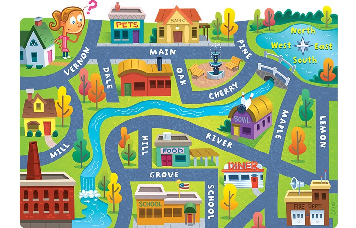
The school is ____ of the pet store.
a)
North
b)
South
c)
East
d)
West
11.
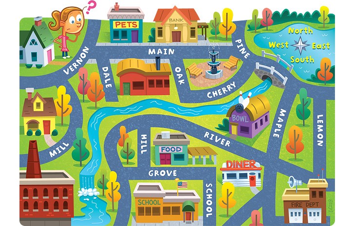
The bank is ____ of the pet store.
a)
East
b)
North
c)
West
d)
South
12.

What country is NORTH of the United States of America?
a)
Mexico
b)
Canada
13.

Name the part of the map labeled with a "C."
a)
Key
b)
Title
c)
Compass Rose
14.
What is a ruler that measures distance?
a)
compass rose
b)
index
c)
scale
d)
inset map
15.
A list that explains the symbols on a map.
a)
legend (key)
b)
compass rose
c)
inset map
d)
cardinal directions
100 %

