
 Worksheets
Map Tools and Skills
Total questions: 31
Worksheet time: 18mins
Name
Class
Date
1.

Which of the following is a cardinal direction?
a)
northwest
b)
east
c)
southeast
d)
lake
2.

Map scale shows what?
a)
directions
b)
cities
c)
distance
d)
time
3.

We live on which continent?
a)
North America
b)
South America
c)
Europe
d)
Australia
4.

If one inch is equivalent to five miles. How many miles is ten inches?
a)
60
b)
20
c)
50
d)
100
5.
Name the imaginary line which divides Northern and Southern hemispheres
a)
Cardinal Direction
b)
South
c)
North
d)
Equator
6.
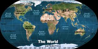
How would you describe Europe's location in relation to Asia
a)
Europe is located east of Aisa.
b)
Europe is located west of Asia.
c)
Europe is located south of Asia.
d)
Europe is located north of Asia
7.
Which example best describe absolute location.
a)
Evans school is close to PSA
b)
My house next to the LA Zoo
c)
I live next to Walmart
d)
Australia is 23.5° S and 135° E
8.

These lines run east and west but the measure distances of the earth north and south of the equator.
a)
longitude
b)
latitude
c)
equator
d)
location
9.
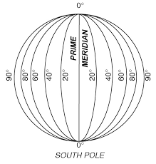
These lines run north and south but they measure distances of the earth east and west of the Prime Meridian.
a)
longitude
b)
latitude
c)
equator
d)
location
10.

Which continent is located at 60° N and 120° E
a)
North America
b)
South America
c)
Asia
d)
Europe
11.
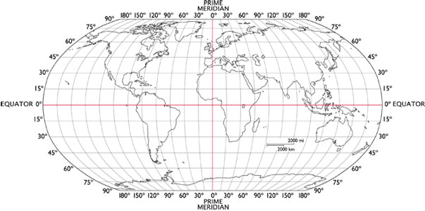
Which continent is located at 30° S and 135° E
a)
North America
b)
Australia
c)
Asia
d)
Europe
12.
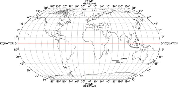
Which continent is located at 60° N and 120° W
a)
North America
b)
South America
c)
Asia
d)
Europe
13.
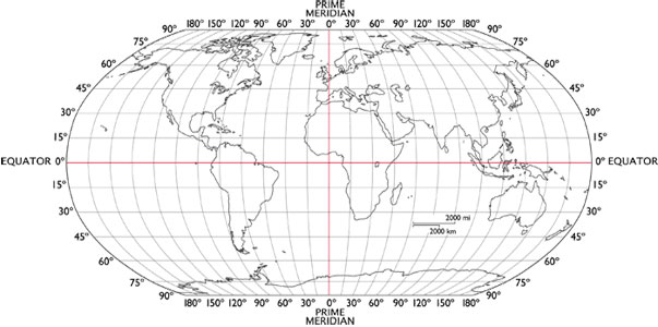
Which continent is located at 0° equator and 60° W
a)
North America
b)
South America
c)
Asia
d)
Europe
14.
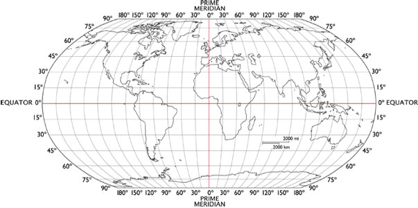
Which continent is located at 45° N and 30° E
a)
North America
b)
South America
c)
Asia
d)
Europe
15.

Which continent is directly east of North America?
a)
Europe
b)
South America
c)
Antarctica
d)
Australia
16.

Which continent is South of Europe?
a)
North America
b)
South America
c)
Africa
d)
Asia
17.

Which continent is EAST of Europe?
a)
North America
b)
Africa
c)
Antarctica
d)
Asia
18.

A model of the Earth, used to avoid distortions in spatial relations on the world is called
a)
a globe
b)
a map
c)
Sim City
d)
an atlas
19.

Latitude measures......
a)
East and West of the Prime Meridian
b)
North or South of the Equator
c)
East or West of the Equator
d)
North or South of the Prime Meridian
20.

Longitude measures
a)
East or West of the Prime Meridian
b)
North or South of the Equator
c)
East or West of the Equator
d)
North or South of the Prime Meridian
21.

Which two continents are located entirely in the Western Hemisphere?
a)
Europe and Africa
b)
Asia and Antarctica
c)
North America and Australia
d)
North America and South America
22.

What does a map’s scale compare?
a)
direction on a map with direction on Earth
b)
distance on a map with distance on Earth
c)
location on a map with location on a globe
d)
distortion on a map with distortion on a globe
23.
imaginary line found at zero degrees longitude
a)
Prime Meridian
b)
Equator
c)
Longitude
d)
Latitude
24.
a tool on a map that shows cardinal directions and sometimes intermediate directions
a)
Compass Rose
b)
Rose Graph
c)
Legend
d)
Map Key
25.

Which hemisphere is shaded dark on the map?
a)
northern hemisphere
b)
southern hemisphere
c)
eastern hemisphere
d)
western hemisphere
26.

Which side of this map is west?
a)
top
b)
bottom
c)
left
d)
right
27.
What imaginary line determines time?
a)
Prime Meridian
b)
Equator
c)
Tropic of Cancer
d)
Tropic of Capricorn
28.
What imaginary line determines climate?
a)
Tropic of Cancer
b)
Prime Meridian
c)
Equator
d)
Tropic of Capricorn
29.

A _________ is used to represent real objects on the map such as a building, road, lake, tree, mountain, etc.
a)
Symbol
b)
Compass Rose
c)
Map Scale
d)
Merdian
30.
How many continents are there?
a)
4
b)
1
c)
5
d)
7
31.

What is the approximate location of letter B?
a)
80oN, 0o
b)
0o, 80oW
c)
80oS, 0o
d)
0o, 80oE
100 %

