Wayground logo

Free Printable Worksheets

Font size

S
M
L
XL
Worksheets

Map Skills

Total questions: 80

Worksheet time: 4hrs 50mins

Name
Class
Date
1.
What is the map element that tells what symbols on the map mean?
a)
Key/Compass
b)
Key/Legend
c)
Legend/Scale
d)
Inset/Scale
2.
This map element tells the purpose of the map
a)
Title
b)
Scale
c)
Legend
d)
Key
3.
This element gives measurements  and shows distance between objects on the map
a)
Legend
b)
Key
c)
Title
d)
Scale
4.
Which map element is a smaller map that shows a "larger" area of land around the map.
a)
Title / Scale
b)
Key / Legend
c)
Inset Map
d)
Compass Rose
5.
What map element has a directional arrow that shows cardinal and sometimes intermediate directions on a map?
a)
Compass Rose
b)
Inset Map
c)
Key Legend
d)
Title Scale
6.
Which continent is located at letter "A"?
a)
Antarctica
b)
Africa
c)
Australia
d)
Asia
7.
Which continent is located at letter "B"?
a)
North America
b)
South America
c)
Central America
d)
African America
8.
Which continent is located at letter "C"?
a)
North America
b)
South America
c)
Central America
d)
African America
9.
Which continent is located at letter "D"?
a)
Asia
b)
Africa
c)
Europe
d)
Australia
10.
Which continent is located at letter "E"?
a)
Africa
b)
Asia
c)
Australia
d)
Antarctica
Antarctica
11.
Which continent is located at letter "F"?
a)
Asia
b)
Africa
c)
Australia
d)
Antarctica
12.
Which continent is located at letter "G"?
a)
Asia
b)
Africa
c)
Australia
d)
Antarctica
13.
Which ocean is located at letter "I"?
a)
Atlantic
b)
Pacific
c)
Indian
d)
Arctic
14.
Which ocean is located at letter "H"?
a)
Atlantic
b)
Pacific
c)
Indian
d)
Arctic
15.
Which ocean is located at letter "J"?
a)
Atlantic
b)
Pacific
c)
Indian
d)
Arctic
16.
Which ocean is located at letter "K"?
a)
Atlantic
b)
Pacific
c)
Indian
d)
Arctic
17.
Measures distance from the equator. These lines run east and west and measure north and south.
a)
Cardinal Directions
b)
Latitude Lines
c)
Longitude Lines
d)
Intermediate Directions
18.
__________ identifies distances on a map.  It refers to the relationship (or ratio) between distance on a map and the matching distance on the earth.
a)
Map Scale
b)
Cardinal Directions
c)
Intermediate Directions
d)
Symbols
19.
__________ directions are northeast, southeast, southwest, and northwest.
a)
Latitude
b)
Cardinal
c)
Intermediate
d)
Longitudinal
20.
This type of map shows physical features of the land, including valleys, canyons, plains, and mountains.
a)
Political
b)
Physical
c)
Time Zones
d)
Map Key
21.
A _________ is used to represent real objects on the map such as a building, road, lake, tree, mountain, etc.
a)
Symbol
b)
Compass Rose
c)
Map Scale
d)
Merdian
22.
__________ measures distance from the Prime Meridian.  These imaginary lines run from the north pole to the south pole.  These lines run north and south and measure east or wes
a)
Latitude 
b)
Longitude
c)
Lines
d)
Equator
23.
 A __________ is used to identify the direction of north, south, east, and west.
a)
Compass Rose
b)
Map Scale
c)
Latitude Lines
d)
Longitude Lines
24.
The __________ directions are north, east, south, and west.
a)
cardinal
b)
intermediate
c)
map
d)
most imprtant
25.
 This type of map shows governmental boundaries of countries, states, and/or counties.  It sometimes includes cities, roads, and significant bodies of water.
a)
Physical
b)
Political
c)
Product
d)
Map
26.
 A __________ is used to identify what the symbols on the map stand for.  The meaning of the symbol may be explained using this.
a)
Physical Map
b)
Map Key
c)
Compass Rose
d)
Map
27.
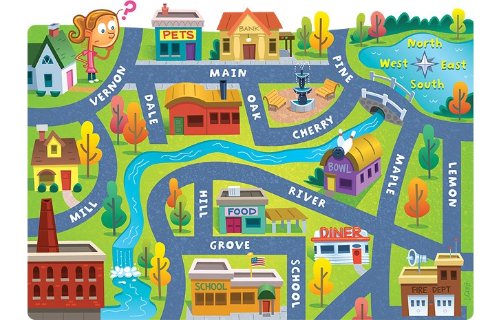
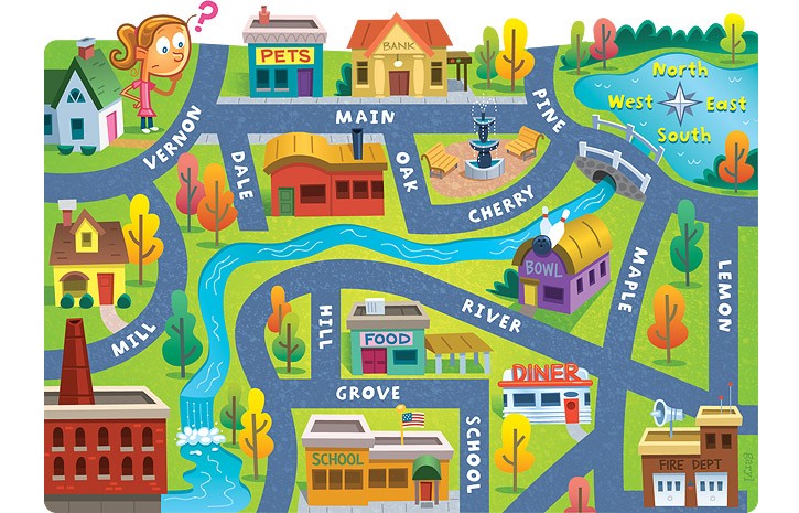
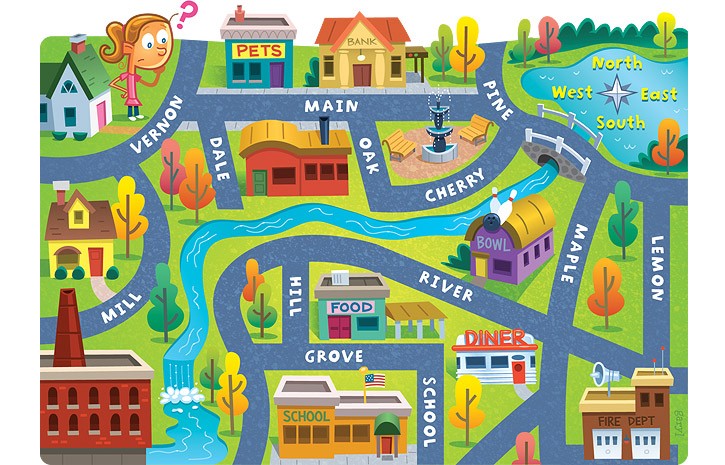
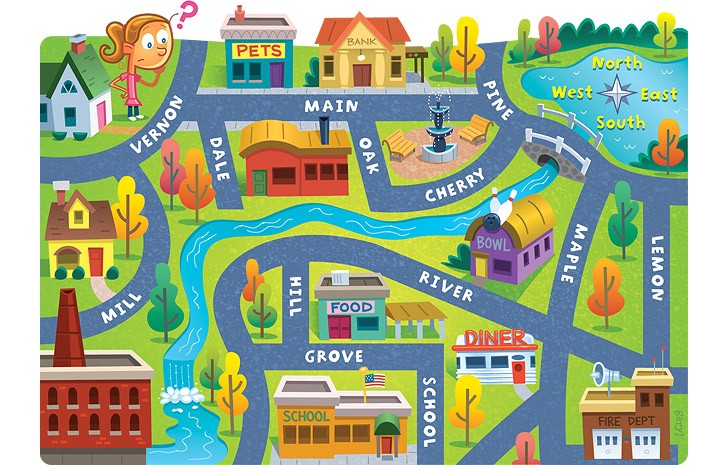
The red question mark is located to the _________ of the compass rose.
a)
North 
b)
South
c)
East
d)
West
28.
 The red question mark is located to the _________ of the compass rose.
a)
Northeast
b)
Southeast
c)
Northwest
d)
North
29.
 The red question mark is located to the _________ of the compass rose.
a)
Southwest
b)
Southeast
c)
South
d)
West
30.
The red question mark is located to the _________ of the compass rose.
a)
North
b)
Northeast
c)
Northwest
d)
East
31.
The red question mark is located to the _________ of the compass rose.
a)
North
b)
South
c)
Southeast
d)
Southwest
32.

What tool would you use to measure the distance between two places on a map?

a)

key

b)

legend

c)

scale

d)

grid

33.

The title of a map tells you...

a)

where you are

b)

how many people live there

c)

how many mountains

d)

what type of map is it

34.

Which part of a map shows you symbols and their meanings?

a)

mountains

b)

key or legend

c)

grid map

d)

island

35.

1 inch = 100 miles


What is the distance from Houston to Dallas if it measures 3 inches?

a)

150 miles

b)

200 miles

c)

275 miles

d)

300 miles

36.

1 inch = 50 miles


What is the distance between Sugar Land and Austin if it measures 4 and a half inches?

a)

100 miles

b)

225 miles

c)

250 miles

d)

300 miles

37.

The Rocky Mountains are what direction from the Great Plains?

a)

North

b)

South

c)

East

d)

West

38.
This line measures 0 degrees longitude:
a)
Equator
b)
International Date Line
c)
Meridians
d)
Prime Meridian
39.
The 0 degree line of latitude is the ___________.
a)
Equator
b)
Prime Meridian
c)
International Date Line
d)
Contour line
40.
What is the reason why latitude lines NEVER intersect? 
a)
They converge at the poles
b)
They are cool
c)
They are vertical lines 
d)
They are parallel
41.
What is this object known as?
a)
map symbol
b)
map key
c)
map scale
d)
compass rose
42.
Ocean #4 is ________.
a)
Indian
b)
Atlantic
c)
Pacific
d)
Southern
43.
Name Ocean #1!
a)
Indian
b)
Pacific
c)
Atlantic
d)
Southern
44.

What kind of map is this?

a)

Physical

b)

Political

c)

Globe

45.
Which of the following is NOT a continent?
a)
Africa
b)
North America
c)
Germany
d)
Europe
46.

What type of map is this?

a)

Political

b)

Physical

c)

Economic Activity

47.
How many continents are there?
a)
4
b)
1
c)
5
d)
7
48.

What horizontal lines show the distance north or south of the equator?

a)

prime meridian

b)

tropics

c)

latitude

d)

longitude

49.

What vertical lines show distance east or west of the prime meridian?

a)

prime meridian

b)

longitude

c)

equator

d)

Tropic of Cancer

50.

What name is given to the portion of Earth located ABOVE the equator?

a)

Northern hemisphere

b)

Eastern hemisphere

c)

Western hemisphere

d)

Southern hemisphere

51.

What name is given to the portion of Earth located BELOW the equator?

a)

Northern hemisphere

b)

Eastern hemisphere

c)

Western hemisphere

d)

Southern hemisphere

52.

What imaginary line represents zero (0º) degrees longitude?

a)

prime meridan

b)

longitude

c)

equator

d)

Tropic of Cancer

53.

What name is given to a scale model representation of the Earth?

a)

tellurion

b)

planetarium

c)

globe

d)

observatory

54.

What type of map shows landforms like mountains and deserts?

a)

political map

b)

physical map

c)

resource map

d)

climatic map

55.

What type of map shows governmental boundaries such as countries, counties, and cities?

a)

political map

b)

physical map

c)

resource map

d)

climatic map

56.
What are these lines known as?
a)
latitude
b)
longitude
c)
relative location
d)
absolute location
57.
What  are these lines known as ?
a)
latitude
b)
relative location
c)
longitude
d)
absolute location
58.
Which direction normally is pointing to the top of the page on a map?
a)
North
b)
South
c)
East
d)
West
59.
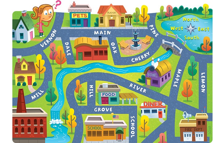
The bank is on what street?
a)
Main
b)
Maple
c)
Lemon
d)
River
60.
The school is ____ of the pet store.
a)
North
b)
South
c)
East
d)
West
61.
Lemon street runs _____________.
a)
East and West
b)
North and South
c)
South and West
d)
North and East
62.
The fire dept. is ______ of the school.
a)
South
b)
East
c)
North
d)
West
63.
The bank is ____ of the pet store.
a)
East
b)
North
c)
West
d)
South
64.
Where would you find the symbol that indicates which city on the map is the capital city?
a)
map scale
b)
map legend
c)
map elevation
d)
map title
65.
What type of map is this?
a)
Population 
b)
Physical
c)
Political
d)
Climate 
66.
Using lines of latitude and longitude to find an exact location is...
a)
Absolute Location
b)
Relative Location
c)
Prime Meridian
d)
Place
67.
Relative location is...
a)
how to get to a place
b)
finding the location of a place by describing its location from another place
c)
not a real thing
d)
exactly where something is located
68.
What is the measure of how far north or south a place is from the Equator called?
a)
Latitude
b)
Longitude
c)
Prime Meridian
69.
What is the measure of how far east or west a place is from the Prime Meridian called?
a)
Latitude
b)
Longitude
c)
Equator
70.
Latitude and Longitude are measured in ________.
a)
inches
b)
feet
c)
degrees
d)
grams
71.

a large land mass that is part of the Earth’s crust; geographers identify seven of them

a)

globe

b)

earth

c)

continent

d)

map

72.

a flat drawing that shows all or part of the earth’s surface

a)

globe

b)

earth

c)

continent

d)

map

73.

the distance north or south of the Earth’s equator

a)

prime meridian

b)

latitude

c)

longitude

d)

equator

74.

the half of the globe between the prime meridian and 180 degrees longitude that includes most of Africa and Europe as well as Asia, Australia, and the Indian Ocean

a)

southern hemisphere

b)

northern hemisphere

c)

eastern hemisphere

d)

western hemisphere

75.

the half of the globe between 180 degrees and the prime meridian that includes North and South America and the Pacific and Atlantic oceans

a)

southern hemisphere

b)

northern hemisphere

c)

eastern hemisphere

d)

western hemisphere

76.

an imaginary line that runs through Greenwich, England at 0 degrees longitude

a)

prime meridian

b)

equator

c)

northern hemisphere

d)

hemisphere

77.
Which of the following is an intermediate direction?
a)
North
b)
South
c)
Northwest
d)
Northsouth
78.
Which STATE is located at...
120°W, 45°N
a)
WA
b)
OR
c)
UT
d)
ND
79.
Which STATE is located at...
100°W, 48°N
a)
NM
b)
ND
c)
SD
d)
CO
80.
How many miles would 4 inches be equal to?
a)
2
b)
400
c)
4000
d)
4