

wayground logo

Free Printable Worksheets

NEW

Font size

S
M
L
XL
Worksheets

Maps Review Set

Total questions: 35

Worksheet time: 1hrs 9mins
Name
Class
Date
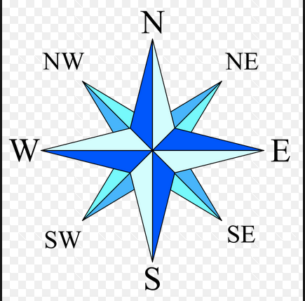
1.
What is this object known as?
a)
map symbol
b)
map key
c)
map scale
d)
compass rose
2.

How do you know what the purpose of a map is?

a)

Read the title

b)

Look at the map key

c)

Look at the compass rose

d)

Read the scale bar

3.

An imaginary line or meridian measuring east or west of the prime meridian tells you a location's ________.

a)

longitude

b)

langoustine

c)

latitude

d)

geography

4.
On which two hemispheres do we live?
a)
Northern and Eastern
b)
Eastern and Southern
c)
Western and Southern
d)
Northern and Western
5.
What is a scale bar for?
a)
to know the cardinal points
b)
to know the symbology of a map
c)
to know distances in a map
d)
to know the political divisions
6.

A pattern formed as parallels and meridians cross one another on a map.

a)

Compass

b)

Map scale

c)

Legend/key

d)

Grid

7.

Which one is not a basic component of a map?

a)

Title

b)

Compass

c)

Color Code

d)

Scale

8.
What is the name of this line at 0 degrees latitude?
a)
Prime Meridian
b)
Equator
c)
North Pole
d)
South Pole
9.
What is the name of the line at zero degrees longitude?
a)
Equator
b)
Prime Meridian
c)
North Pole
d)
South Pole
10.

_______ lines on a globe run from east to west but measure north to south.

a)

North Pole

b)

South Pole

c)

Latitude

d)

Longitude

11.

_______ lines on a globe run from North to South but measure east to west.

a)

North Pole

b)

South Pole

c)

Latitude

d)

Longitude

12.
The Equator divides Earth into which two hemispheres
a)
Northern and Western
b)
Northern and Southern
c)
Eastern and Western
d)
Southern and Western
13.

Parallels and meridians together form a ________

a)

global map

b)

global grid

c)

global course

d)

global world

14.

The ARCTIC CIRCLE can be found at the bottom of the Earth.

a)

True

b)

False

15.

A locator globe _______________

a)

provides you with directions so you know which way to go.

b)

tells you the city you are looking at on map

c)

is a map that zooms in on the physical features of a location.

d)

is a picture of a globe that shows you where in the world the map is located.

16.

Imaginary lines that run north and south meeting at the pole but measure in degrees east and west

a)

latitude

b)

parallels

c)

longitude

d)

primes

17.
Is the Tropic of Cancer ABOVE the Equator or BELOW the Equator?
a)
Above
b)
Below
18.
What city is located at about 39 degrees North latitude and 108 degrees West longitude?
a)
Durango
b)
Delta
c)
Boulder
d)
Denver
19.
Lines of Longitude measure how far from the _______ a place is located.
a)
Equator
b)
International Date Line
c)
Prime Meridian
d)
Tropic of Cancer
20.
Lines of Latitude can be measured up to what degree?
a)
150 degrees
b)
180 degrees
c)
90 degrees
d)
100 degrees
21.
Antarctica, Australia, and most of South America are in what hemisphere? 
a)
Northern 
b)
Southern 
c)
Western 
d)
Eastern
22.
Lines of latitude are also called  __________.
a)
hemispheres
b)
Parallels
c)
Meridians
d)
Tropics
23.
Lines of longitude are also called  ____________.
a)
Hemispheres
b)
Meridians
c)
parallels
d)
International Date Lines
24.

Location D is located at which coordinates?

a)

30oN, 90oW

b)

90oN, 30oW

c)

10oN, 40oW

d)

30oN, 90oE

25.

Location H is located at which coordinates?

a)

60oN, 120oE

b)

90oN, 30oE

c)

10oS, 40oW

d)

30oN, 90oE

26.

Which point is located at 30oS, 30oE?

a)

K

b)

D

c)

E

d)

G

27.

Which point is located at 30oS, 150oE?

a)

K

b)

D

c)

E

d)

G

28.

Which point is located at 45oN, 30oE?

a)

K

b)

D

c)

E

d)

G

29.
What is the approximate location of letter B?
a)
80oN, 0o
b)
0o, 80oW
c)
80oS, 0o
d)
0o, 80oE
30.
a)
The map show the lines of longitude.
b)
The map shows the lines of latitude.
31.
a)
The map shows lines of longitude.
b)
The map shows lines of latitude.
32.
To locate a place on the earth, you need to look at...
a)
where the lines of latitude and longitude meet
b)
the lines of latitude only
c)
the lines of longitude only
d)
the compass rose
33.

The map below shows three locations, labeled A, X, and B, on Earth's surface.

Which table correctly indicates the solar times at locations A and B when it is 12 noon at location X?

a)
b)
c)
d)
34.

Approximately how wide is each time zone, in degrees?

a)

5o

b)

10o

c)

15o

d)

20o

35.

When considering time zones, true or false, west is less and east increase?

a)

True

b)

False





