
Font size
 Worksheets
World geography Assessment 1
Total questions: 114
Worksheet time: 1hrs 5mins


What is the name of the yellow continent?
Australia
North America
The United States
Australia
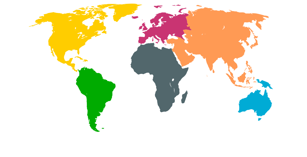
What is the name of the grey continent?
North America
South America
Africa
Asia

What is the name of the green continent?
North America
Brazil
South America
Africa

What is the name of the blue continent?
Africa
Asia
Australia
Orange

What is the name of the orange continent?
Europe
Asia
Russia
China

What is the name of the pink/red continent?
Europe
Asia
North America
Australia

Which continent is South of North America?
Mexico
South America
Africa
Brazil

Which continent is directly North of Australia?
Asia
Africa
North America
Europe
Which of the following countries is in North America?
Canada
Chile
Greece
Japan
True or False: Spain is a country in Europe.
True
False
True or False: The U.S. is a country in North America.
True
False
True or False: Mexico is a country in South America
True
False
Which Country is not in North Africa?
Sudan
Iran
Algeria
Morocco
Which Country is located in South West Asia
Iran
Sudan
Algeria
Morocco
A civil war in this country has forced millions to flee their homes and become refugees.
Syria
Algeria
Saudi Arabia
Iraq
This is the name of the Jewish holy book.
The Torah
The Bible
The Quran
The New Testament

These ancient wonders were used...
As a burial site for Pharaohs and Royals in Ancient Egypt
A way of sending a message to other civilizations
For astronomical study
To store food
The longest river in the world is the
Nile
Amazon
Congo
Mississippi
What figure founded Christianity?
Jesus
Mohammed
Moses
Mark
Petroleum is a very important global resource. It is also more commonly known as
Oil
Vaseline
Fossils
Uranium

This language uses symbols in place of words and was widely used in Ancient Egypt
Hieroglyphics
Greek
Sanskrit
Klingon
What is the connection between Christianity, Judaism, and Islam?
Abraham, Monotheism, Sacred Books
Easter, Abraham, Ten Commandments
Mecca, Jerusalem, Saudi Arabia
Santa, Easter Bunny, Tooth Fairy
What geographic feature of North Africa may have caused it to develop differently from Southern Africa?
Sahara Desert
Arabian Sea
Congo River Basin
Great Rift Valley

The study of Earth, its people, places, and environments
Geology
Geography
Geneaology
Anthropology

How far above sea level a feature is
Landforms
Landscapes
Elevation
Environment

The natural surroundings of a place
Landscapes
Landforms
Climate
Environment

A material that can used to create a crop or other products.
Climate
Product
Lumber
Resource

The average weather of a place over a period of time.
Climate
Region
Seasons

A natural feature found on land
Landscape
Environment
Resources
Landforms

Portion of the Earth's surface that can be viewed at one time from one location.
Resources
Landforms
Lanscape
Environment

Which of the following is a Geographer most likely to study?
Events that occur over time and how events are connected
People and the world in which they live
Production, distribution, and consumption of goods/servicesThis is a wrong answer
How living things survive and relate to one anotherThis is a wrong answer

Why do geographers study specific regions?
To describe the physical beauty and complexity of places
To understand the most general physical features of places
To identify the broad patterns of larger areas
To analyze the location and size of things

Name for the unique locations on Earth that defined by both human and physical characteristics.
Places
Environments
Vistas
Landscapes

Why do geographers study more than a places location and dimensions?
To gain a better understanding of what the place it like
To explain how it differs from other places
To describe kinds of meanings the place holds for people
ALL OPTIONS ARE CORRECT
What is the chief disadvantage of maps?
Maps show less information than globes
Maps are flat and are not round like globes
Maps distort physical reality, or show it incorrectly
Maps show a part of the whole planet

Lines on a globe that run North to South; also called meridians.
Latitude
Longitude

Starting point for measuring Longitude; starting point is 0 degrees.
Equator
Prime Meridian

East west lines on a globe; also called parallels
Longitude
Latitude

Starting point for measuring Latitude; starting point is 0 degrees.
Equator
Prime Meridian


Biggest landmass on the globe. There are 7.
map scale
northern hemisphere
continent
map

The imaginary line around the middle of the earth. VERY
northern hemisphere
legend
compass rose
equator

What is geography?
the study of Earth's physical features and human activity
the study of fossils
the study of history


What continent is this?
Africa
South America
Australia
Antarctica

What continent is this?
Eurasia
North America
South America
Australia

Which ocean is this?
Arctic
Pacific
Indian
Atlantic

Which ocean is this?
Arctic
Pacific
Indian
Atlantic
How many oceans are there?
3
4
5
6

These maps show country and state boundaries, as well as the location of capitals, other major cities, and bodies of water.
Political map
Climate map
Physical map
Historical map
Lines of longitude measure
Distance in degrees east and west of the Prime Meridian
Distance in degrees north and south of the Equator
The distortion on a map
The population density of an area
This helps you determine the distance between two points on a map
Large scale map
Scale of miles and kilometers
Prime meridian
Per capital GDP
These lines measure distance in degrees north and south of the equator.
Lines of longitude
Scale of miles/kilometers
Tropic of Cancer
Lines of latitude
Hemispheres are half spheres.
True
False
What does GDP stand for?
Gross National Product
Grand Domestic Product
Gross Domestic Product
Giant Domestic Product
Since when has the world been using time zones?
The late 19th century
The early 19th century
The late 20th century
The early 18th century
A map that shows the average number of people per square mile in a particular area is called
A climate map
A small scale map
A historical map
A population density map
What kind of map would you look at if you wanted to find different heights above sea level?
Climate map
Elevation map
Population density map
Historical map
What does per capita mean?
Per square mile
Per caption
Per person
Per percentage
Which of the following modes of transportation was the reason why time zones were created?
Airplanes
Boats/ships
Automobiles
Railroads
This map provides information about the past.
Historical map
Climate map
Population density map
Elevation map
Which of the following maps is a Mercator projection?


What is the imaginary line that runs east and west around the center of the Earth?
Prime meridian
Tropic of Cancer
Equator
Tropic of Capricorn
Which of the following is a climate map?


Which of the following is a climate map?
What does a compass rose do?
Shows population per square mile.
Shows an area’s elevation.
Shows the climate.
Shows direction (north, south, east, west).

