Worksheets
6th Grade Geography Review
Total questions: 93
Worksheet time: 59mins
characteristics or features in a particular place (e.g., amount of rainfall or number of trees)
Connections
Conditions
Physical Geography
Human Geography
natural or human-made links between two places (e.g., a river, a highway)
Connections
Conditions
Defense
cropland
land which can be used to grow plants that people use (e.g., corn for food or cotton for fiber)
cropland
grow land
connections
conditions
study of where people have decided to live and what they have chosen to build and do in different parts of the the Earth.
Human Geography
Physical Geography
Biology
Psychology
study of the Earth's land, air, and water (including mountains and soils, weather and climate, rivers, lakes, and oceans)
Human Geography
Physical Geography
Awesome Geography
Biology with Geography
Water Supply
water that people can use to drink or to raise plants and animals
place that had an especially large population and a large number of public buildings and private homes early in human history
a place next to water (ocean, lake, river) where ships or large boats can safely unload or load goods and people onto the land.
land that is usually covered by shallow water that plants grow in
a line of latitude that is near the South Pole; also called the 66.5 degree south latitude line
Arctic Circle
Antarctic Circle
a line of latitude that is near the North Pole; also called the 66.5 degree north latitude line
Antarctic Circle
Arctic Circle
a line of latitude that is halfway between the North Pole and the South Pole; also called the zero(0) degree latitude line
Tropic of Cancer
Tropic of Capricorn
Equator
Prime Meridian
refers to the whole world
Global
Regional
Territorial
District
the months during a year when temperatures are high enough for plants (especially crops that provide food for people) to grow
Cropland
Growing Season
Harvest Moon
a set of lines that geographers draw on the earth because they want to describe locations in relation to the Equator and the North and South Poles.
Latitude
Longitude
a group of places that are alike in some way AND also are near each other
Region
District
Pattern
Area
refers to the size of an area that geographers are studying; can vary from looking at the whole world (a global scale) to zooming in on smaller areas inside the world (for example, a continent, a country inside a continent, a city inside a country)
Region
Movement
Spatial Scale
a line of latitude that is north of the Equator, but closer to the Equator than to the North Pole; also called the 23.5 degree north latitude line
Tropic of Cancer
Tropic of Capricorn
Equator
Prime Meridian
a line of latitude that is south of the Equator, but closer to the Equator than to the South Pole; also called the 23.5 degree south latitude line
Tropic of Cancer
Tropic of Capricorn
Equator
Prime Meridian
half of the globe (e.g., the half that is north of the Equator is the Northern Hemisphere; the half that is south of the equator is the Southern Hemisphere).
Tropic of Cancer
Tropic of Capricorn
Equator
Hemisphere

Which regions of long life expectancy (80 or more years)
United States- North America
Japan, Korea - Asia
Nigeria- Africa
Brazil - South America
Which regions of short life expectancy (less than 60 years).
Majority of African countries
Majority of Asian countries
South America
Europe

Which region of low infant mortality (10 or lower).
India, Asia
Brazil, South America
Great Britain, Europe
Mexico, North America
Find regions of high infant mortality (41 or more).
India, Asia
Brazil, South America
Great Britain, Europe
Mexico, North America

Find regions of low percentages who have access to electricity (60% or less).
Which continents are they in? Choose 2
Europe
Asia
Australia
Africa

Find regions where moms have the most children (4.1 or more).
Which continents are they in
North America
South America
Europe
Africa
Find regions where moms have the fewest children (1.7 or less).
Which continents are they in
Australia
South America
Europe
Africa

Find regions where percentages for children are high (40% or more).
Which continents are they in?
South America
North America
Australia
Africa
Find regions where percentages for children are low (20% or less).
Which continents are they in? Choose 2
South America
North America
Australia
Africa

Find regions where lower percentages of adults are literate (70% or less).
Which continents are they in? Choose 2
Asia
Africa
Australia
Europe
Find regions where high percentages of adults are literate (99% or more).
Which continents are they in? Choose 2
South America
Africa
Australia
Europe
What is the world's most populous country?
India
China
U.S.
Mexico
One reason the world is growing so quickly is because...
The world has infinite resources for everyone
Birth rate is higher than death rate
There are more and more places for people to live
Death rate is higher than birth rate
Most of the world's population lives in...
North America
Europe
Africa
Asia

average number of children a woman will have in her lifetime for a given area
birth rate
fertility rate
infant rate
rate of natural increase
Which type of agriculture is mainly practiced in developed nations?
hunting and gathering
subsistence agriculture
commercial agriculture
fishing
Those 0-14 and 65+ are usually classified as?
Dependents
Working Group - Independents
Working Age
Baby Boomers
Those 15 - 65 are usually classified as?
Dependents
Working Group - Independents
Facilitators
Baby Boomers
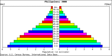


As a country slows in population growth, its pyramid shape will:
Become wider at the base and narrower at the top
Be inverted
Become more rectangular
Bulge in the middle

Growing/Increasing Population
Stationary Population
Declining Population

Those 0-14 and 65+ are usually classified as?
Dependents
Working Group - Independents
Working Age
Baby Boomers

Which type of population is illustrated by this population pyramid?
Fast growing
Slow growing
Stationary (not growing or shrinking)
Negative growth (shrinking)
As a country slows in population growth, its pyramid shape will:
Become wider at the base and narrower at the top
Be inverted
Become more rectangular
Bulge in the middle
In an advanced stage of industrialization, a country will exhibit which set of characteristics?
Low birth and death rates, stable population, good living conditions, long life expectancy.
High birth and death rates, stable population, poor living condition, short life expectancy.
High birth rate and low death rate, growing population, good living conditions, long life expectancy.
High birth and death rates, stable population, harsh living conditions, short life expectancy
Which population pyramid would be encouraging immigration?


What is 1
Great Plains grass region
Southern cotton/pine region
Central American
and Caribbean
hot and hilly region
Western mountain region
Great Lakes farm region
What is 3
Great Plains grass region
Southern cotton/pine region
Central American
and Caribbean
hot and hilly region
Western mountain region
Great Lakes farm region
What is 2
Northern cold region
Southern cotton/pine region
Central American
and Caribbean
hot and hilly region
Western mountain region
Great Lakes farm region
What is 6
Northern cold region
Southern cotton/pine region
Central American
and Caribbean
hot and hilly region
Western mountain region
Great Lakes farm region
What is 5
Northern cold region
Southern cotton/pine region
Central American
and Caribbean
hot and hilly region
Western mountain region
Great Lakes farm region
What is 4
Northern cold region
Southern cotton/pine region
Central American
and Caribbean
hot and hilly region
Western mountain region
Great Lakes farm region

The surroundings or conditions in which a person, animal or plant lives or operates
Terrain
Climate
Environment
the process and time it takes a person to integrate into a new culture and feel comfortable within it.
Criterion
Culture Shock
Rationalization
Cultural Adaptation
a group of places and peoples controlled by one powerful government
Umpire
Empire
region
place
dry places that receive little rainfall, have no trees, have few or no plants; tropical deserts are located 20 to 30 degrees north and south of the Equator
Savanna
Dry Grassland
Swamp
Desert
places with tall trees, warm temperatures in all months, and rainfall at least 10 months; located about 0 to 5 degrees north and south of the Equator
Equatorial rain-forest
Desert
Dry Grassland
Savanna
places where most plants are short (short grasses, not trees) because they need only small amounts of water; tropical grasslands are located 15 to 20 degrees north and south of the Equator
Equatorial rain-forest
Desert
Grassland
Savanna
the physical environment (plants, animals, soils, climate) in a place
Place
Region
Habitat
State
a disease that occurs in places that are warm and have rainfall most of the year; spread by mosquitoes
Small Pox
Malaria
Polio
Chicken Pox
a plant with seeds that people use for food; it grows in warm dry areas (e.g. grasslands)
Millet
Oatmeal
Barely
Quaker's Oats
water in the form of rain, snow, sleet or hail that falls on the land
Prescription
Precipitation
Hydrosphere
Perception
an animal that hunts and eats other animals
predator
Prey
places near the Equator that receive more than 4 inches of rain in most months of the year
Sun Belt
Rainy Belt
Bread Belt
lack of rain to meet the needs of plants (e.g. the difference between the rain that trees need and the amount that actually falls in a month)
surplus
deficit
a special graph that shows average temperatures and average precipitation for each month at a place
Climate Graph
Regional Graph
Bar Graph
more than enough rain to meet the needs of particular plants (enough rainfall each month for trees to grow in a place)
surplus
deficit



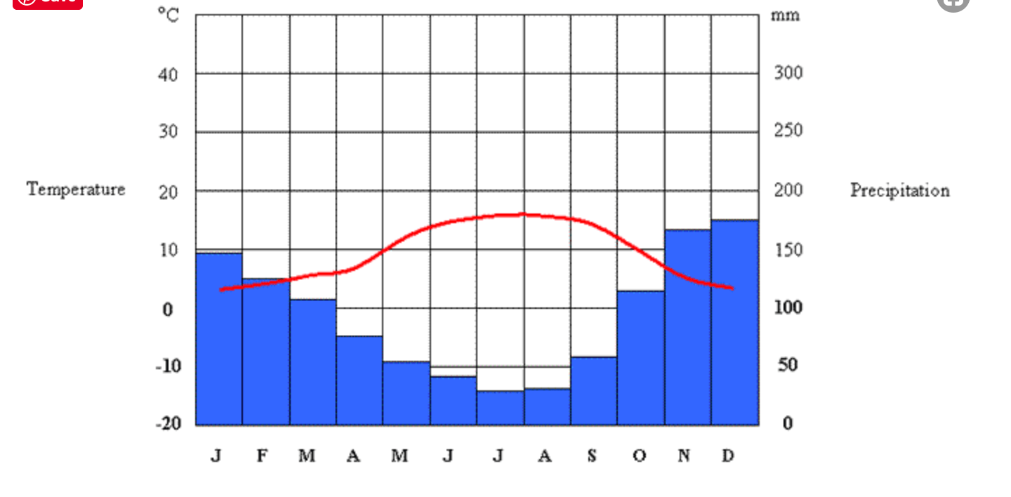
This graph shows the hottest temperatures (red line) in:
June, July and August
January, February, March
October, November, December