Wayground logo

Free Printable Worksheets

Font size

S
M
L
XL
Worksheets

Europe Map Test

Total questions: 50

Worksheet time: 26mins

Name
Class
Date
1.
Which country is 1?
a)
England (United Kingdom)
b)
France
c)
Germany
d)
Spain
2.
Which country is 2?
a)
Russia
b)
Poland
c)
Italy
d)
Spain
3.
Which country is 3?
a)
England (United Kingdom)
b)
Italy
c)
France
d)
Spain
4.
Which country is 4?
a)
Russia
b)
Poland
c)
Germany
d)
France
5.
Which country is 7?
a)
Russia
b)
France
c)
Italy
d)
Poland
6.
Which body of water lies between the United Kingdom and mainland Europe?
a)
Arctic Ocean
b)
Atlantic Ocean
c)
Rhine River
d)
English Channel
7.
Which body of water can be found to the south of Europe?
a)
Atlantic Ocean
b)
Arctic Ocean
c)
English Channel
d)
Mediterranean Sea
8.
What is the name of this tiny country?
a)
France
b)
Germany
c)
Russia
d)
Belgium
9.
Which major geographic feature is highlighted on this map?
a)
The Alps Mountains
b)
The Pyrenees Mountains
c)
Mediterranean Sea
d)
English Channel
10.
Which major geographic feature is highlighted on this map?
a)
Iberian Peninsula
b)
The Alps Mountains
c)
The Ural Mountains
d)
European Plain
11.
-What country is this?
a)
Portugal
b)
Germany
c)
Spain
d)
Italy
12.
-What country is this?
a)
Greece
b)
Lightning
c)
Poland
d)
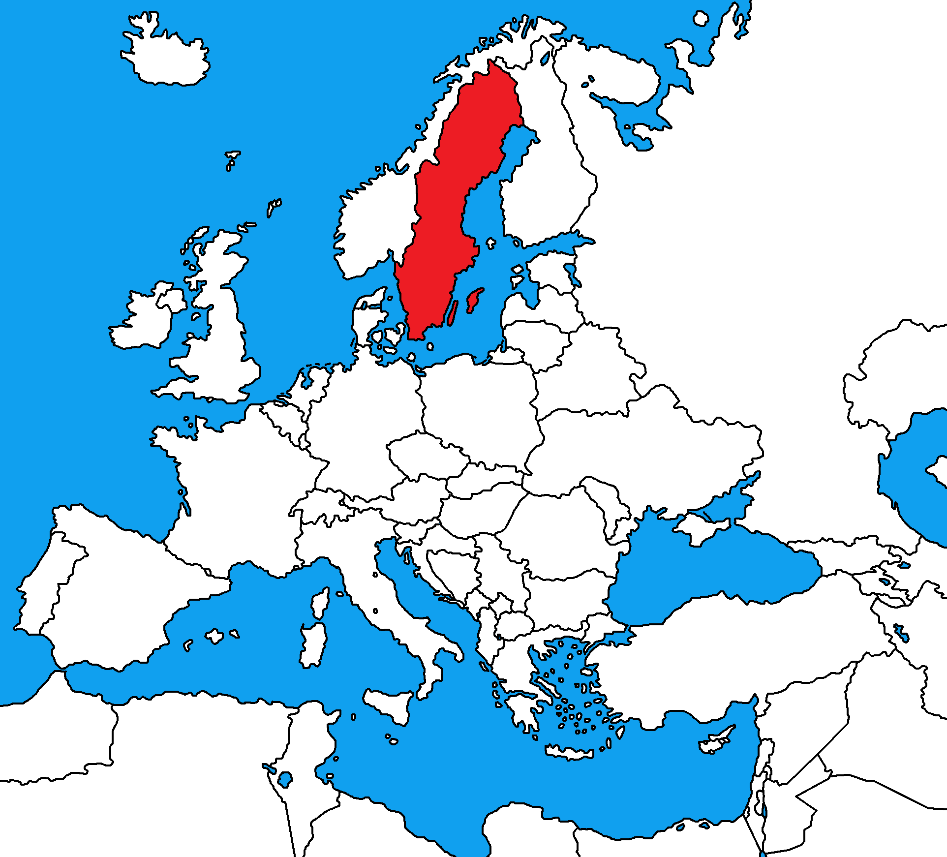
Italy
13.
What country is this?  
a)
Norway 
b)
Finland
c)
Sweden
d)
Germany 
14.
What country is this? 
a)
Austria
b)
France 
c)
Greece 
d)
Norway 
15.
What country is this?  
a)
France
b)
Austria
c)
Spain 
d)
Switzerland 
16.
What country is this?  
a)
France
b)
Portugal
c)
Greece 
d)
Finland 
17.
What sea is located in-between Sweden and Finland?
a)
Mediterranean Sea
b)
Black Sea
c)
Baltic Sea
18.
What beautiful sea inlet lined with high cliffs is located on the western coastline of Norway?
a)
Norwegian Fjords
b)
Norwegian Desert
c)
Norwegian Sea
d)
Norwegian Forest
19.

Which body of water is circled?

a)

Mediterranean Sea

b)

North Sea

c)

Atlantic Ocean

d)

Black Sea

20.

What country is this?

a)

Finland

b)

Belarus

c)

Iceland

d)

Sweden

21.

What country is this?

a)

Germany

b)

France

c)

Hungary

d)

Italy

22.

What country is this?

a)

Russia

b)

Romania

c)

Poland

d)

Spain

23.

What country is this?

a)

France

b)

Poland

c)

Sweden

d)

Iceland

24.

Which body of water is circled?

a)

North Sea

b)

Atlantic Ocean

c)

Mediterranean Sea

d)

Black Sea

25.

What country is this?

a)

Iceland

b)

Norway

c)

United Kingdom

d)

Italy

26.

What country is this?

a)

Hungary

b)

Germany

c)

Italy

d)

Czech Republic

27.
True or False: The Pyrenees Mountains create a natural border between France and Spain. 
a)
True
b)
False
28.
The Mediterranean Sea separates Europe and __________________.
a)
Asia
b)
Africa
c)
Australia
d)
South America 
29.
Europe's ____________________creates opportunities to trade and increase tourism.
a)
Long coast lines
b)
Cruise ships
c)
Theme Parks
d)
Double Decker Bus System
30.
What is the major European mountain range?
a)
Alps
b)
Pyranese
c)
Appalachian 
d)
Balkan
31.

What country is I?

a)

Croatia

b)

Bulgaria

c)

Kosovo

d)

Macedonia

32.

What country is this?

a)

Greece

b)

Iceland

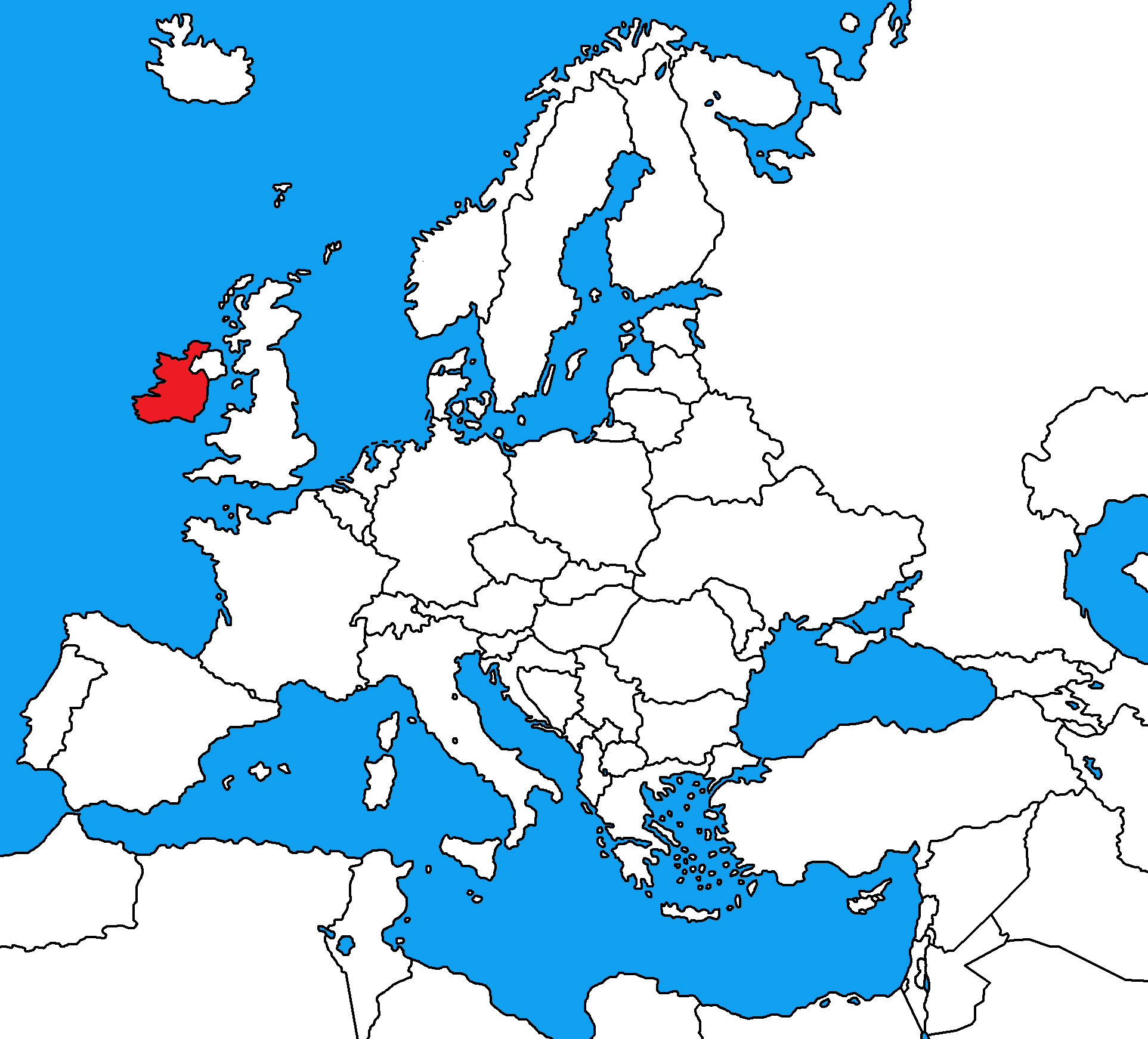
c)

Ireland

d)

United Kingdom

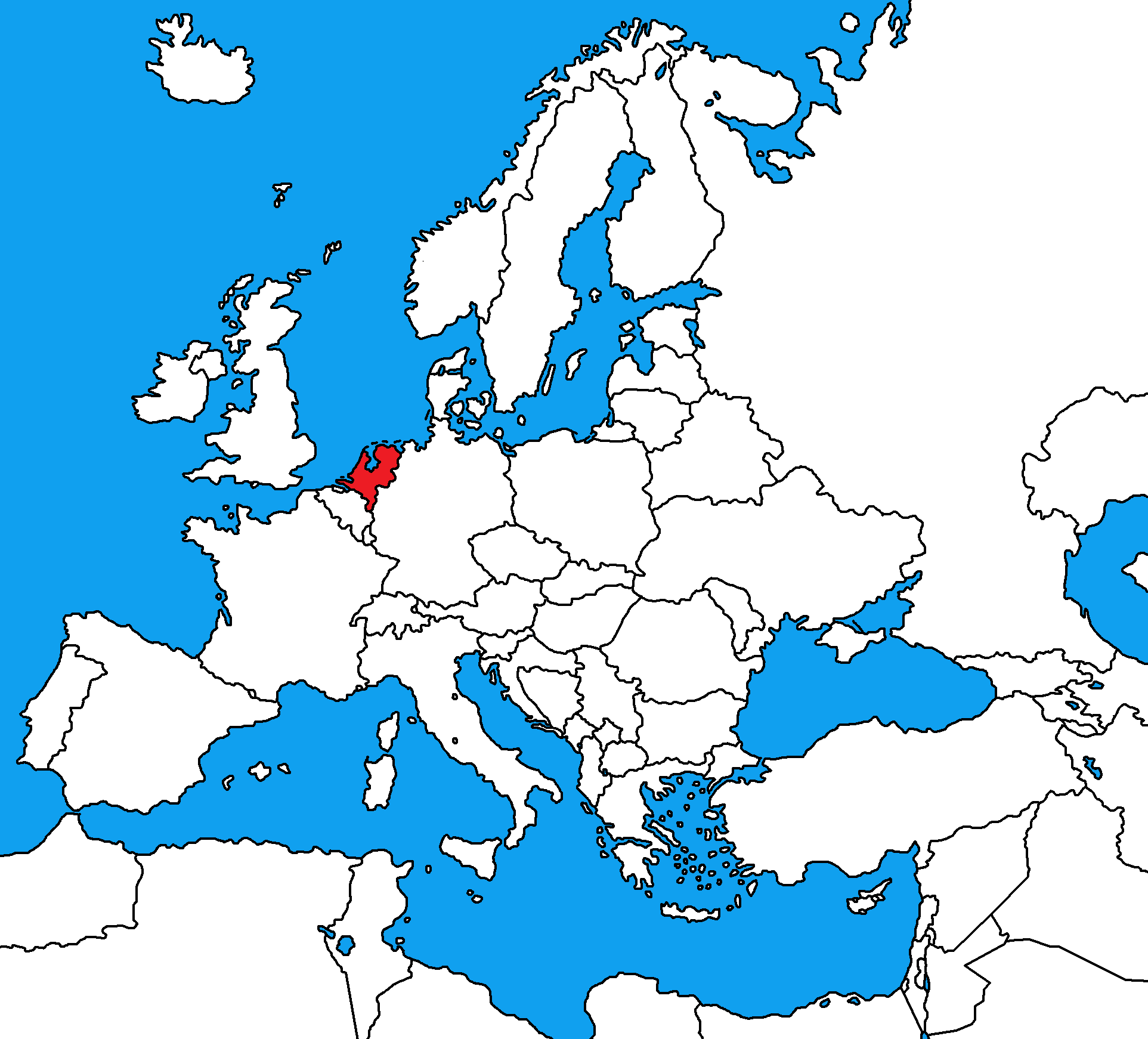
33.

What country is this?

a)

Belgium

b)

France

c)

Netherlands

d)

San Marino

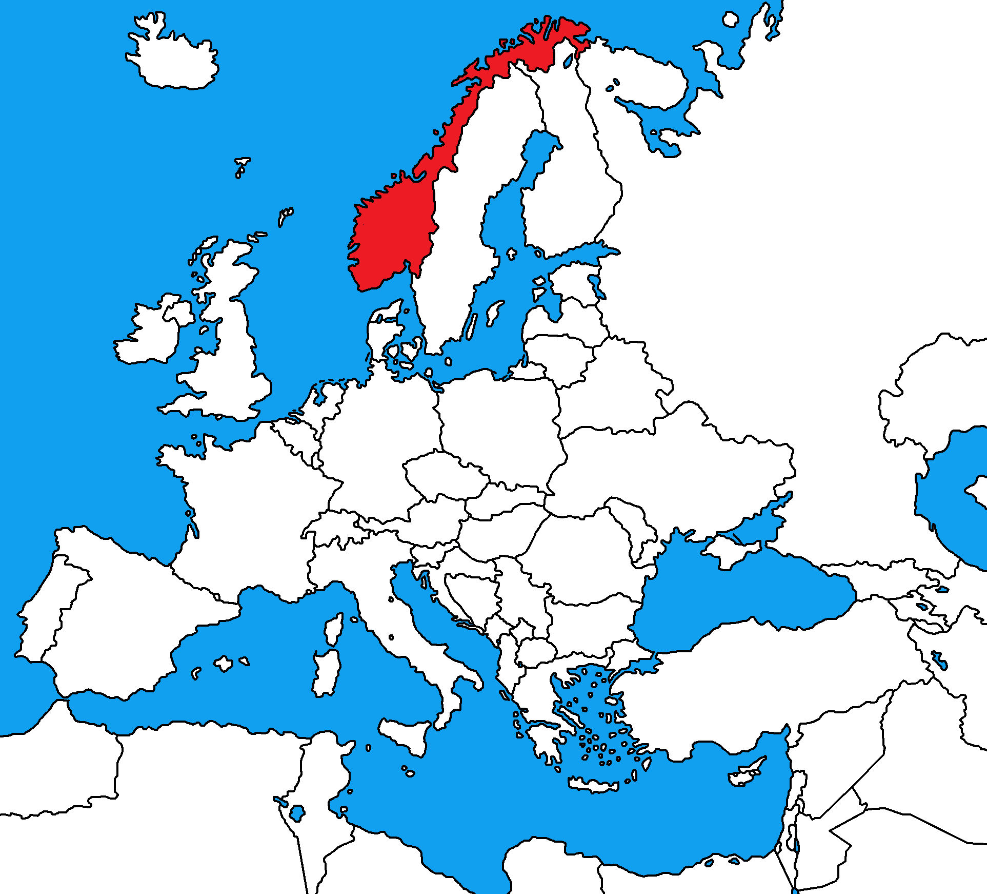
34.

What country is this?

a)

Denmark

b)

Finland

c)

Norway

d)

Sweden

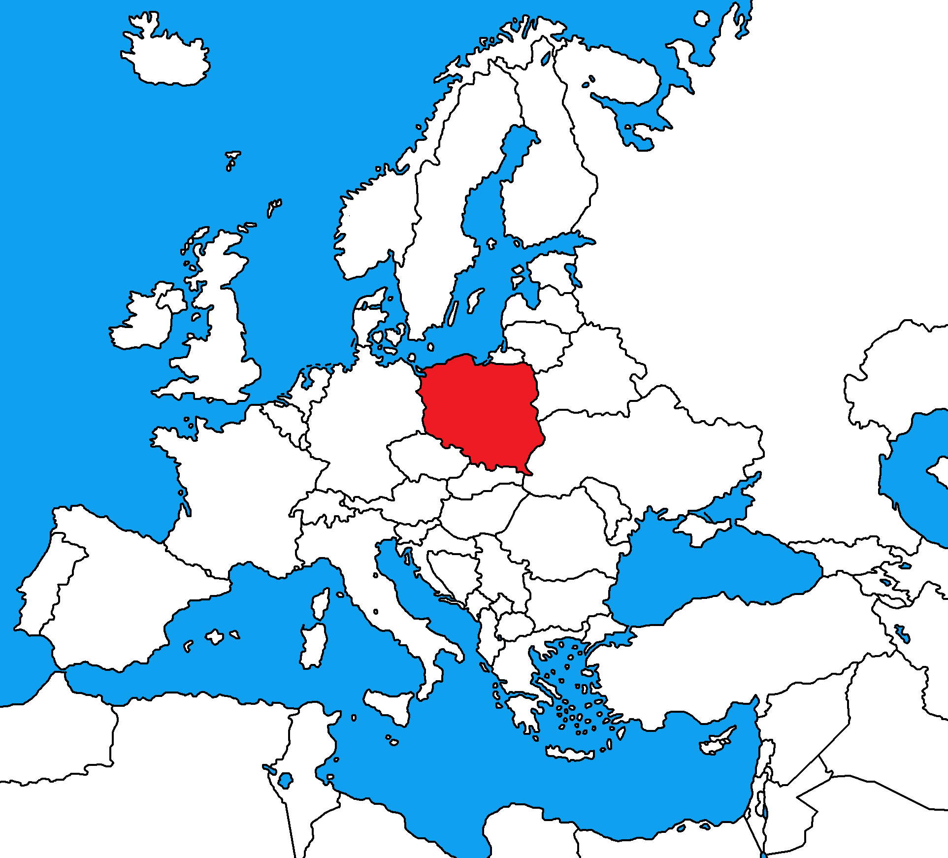
35.

What country is this?

a)

France

b)

Germany

c)

Poland

d)

Ukraine

36.

What country is this?

a)

Denmark

b)

Finland

c)

Norway

d)

Sweden

37.
Which physical feature is represented by number one?
a)
Pyrenees Mountains
b)
Alps Mountains
c)
Ural Mountains
d)
Rocky Mountains
38.
Which physical feature is represented by number four?
a)
English Channel
b)
Mediterranean Sea
c)
Danube River
d)
Rhine River
39.
Which physical feature is represented by number eight?
a)
English Channel
b)
Mediterranean Sea
c)
Danube River
d)
Rhine River
40.
Which physical feature is represented by number nine?
a)
Iberian Peninsula
b)
Scandinavian Peninsula
c)
Ural Mountains
d)
Alps Mountains
41.
Which number represents Europe?
a)
1
b)
6
c)
7
d)
8
42.
Which number represents the Atlantic Ocean?
a)
2
b)
3
c)
4
d)
9
43.

What is the center line of Latitude

a)

Prime meridian

b)

Meridians

c)

Latitude

d)

Equator

44.

What is the center line of longitude?

a)

Equator

b)

Prime meridian

c)

Longitude

d)

latitude

45.

The main directions on a compass rose are ....

a)

intermediate directions

b)

cardinal directions

c)

general directions

d)

directions

46.

What shows what a map is all about?

a)

Map title

b)

Map scale

c)

Legend or key

d)

Compass rose

47.

What tells us which direction to go?

a)

Map key

b)

Map Title

c)

Compass rose

d)

Scale

48.

What is the purpose of a map’s scale?

a)

to determine the weight of the map

b)

to determine cardinal directions

c)

to determine the depths of water bodies

d)

to determine distance between places

49.

A map key/legend is used to _________________.

a)

measure distance

b)

measure population

c)

explain map symbols

d)

learn cardinal directions

50.

The latitude of the equator is _________________.

a)

90°N

b)

0°

c)

180°

d)

50°