
 Worksheets
Southwest Asia/ North Africa Geography Quiz
Total questions: 20
Worksheet time: 12mins
Name
Class
Date
1.

Which letter indicates the nation of Iran?
a)
a
b)
b
c)
c
d)
d
2.
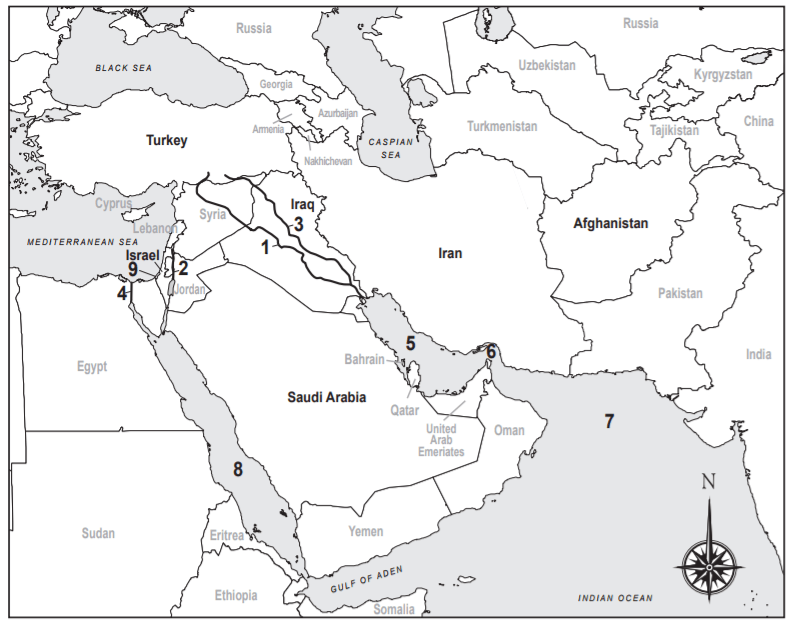
Which Marks the Suez Canal?
a)
1
b)
2
c)
3
d)
4
3.
Which marks the Red Sea?
a)
5
b)
6
c)
7
d)
8
4.
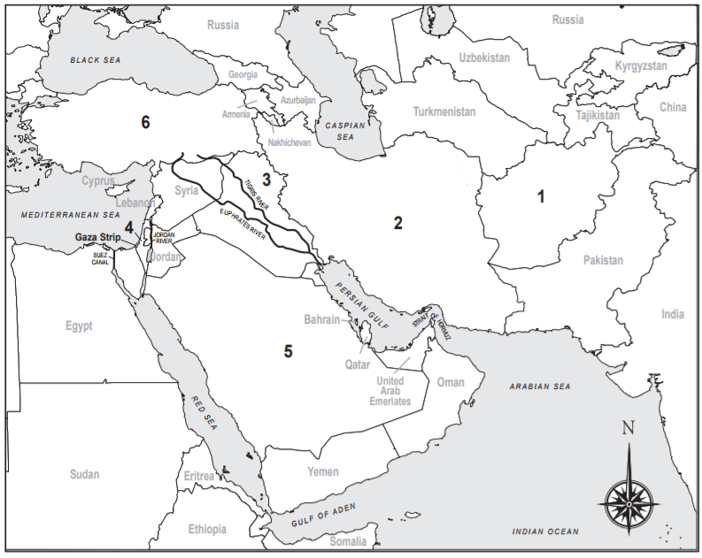
Which number marks Iraq?
a)
2
b)
3
c)
4
d)
6
5.
Which number marks Saudi Arabia?
a)
1
b)
4
c)
5
d)
6
6.
Which country is marked by a “6”?
a)
Iran
b)
Turkey
c)
Jordan
d)
Afghanistan
7.
Which number marks Israel?
a)
1
b)
2
c)
3
d)
4
8.

What feature is represented by the letter H?
a)
Arabian Sea
b)
Pacific Ocean
c)
Persian Gulf
d)
Red Sea
9.

What country is represented by number one?
a)
Iran
b)
Iraq
c)
Afghanistan
d)
Israel
10.

Which body of water is this?
a)
Red Sea
b)
Persian Gulf
c)
Strait of Hormuz
d)
Mediterranean Sea
11.

What country is this?
a)
Iraq
b)
Iran
c)
Israel
d)
Egypt
12.

What country is highlighted in red?
a)
Iraq
b)
Iran
c)
Syria
d)
Kuwait
13.

Where is the Arabian Peninsula?
a)
B
b)
A
c)
M
14.

Where is the Nile River?
a)
E
b)
K
c)
P
15.

Where is the Mediterranean Sea?
a)
O
b)
X
c)
A
16.

Where is the Caspian Sea?
a)
H
b)
R
c)
X
17.

Where is the Persian Gulf?
a)
A
b)
H
c)
O
18.

Where is the Sahara Desert?
a)
B
b)
M
c)
V
19.

Where is the Red Sea?
a)
O
b)
D
c)
H
20.

What dam controls the flow of the Nile River?
a)
Hoover Dam
b)
Aswan High Dam
c)
Falbo Dam
d)
South Fork Dam
100 %

