wayground logo

Free Printable Worksheets

Font size

S
M
L
XL
Worksheets

Map Skills

Total questions: 100

Worksheet time: 1hrs 28mins

Name
Class
Date
1.
Which state borders Ohio to the West?
a)
California
b)
Indiana
c)
Pennsylvania
d)
Michigan
2.
Which state is on the Southwest border of Ohio?
a)
Kentucky
b)
West Virginia
c)
New York
d)
Florida
3.
West Virginia would be considered in which intermediate direction to Ohio?
a)
South
b)
Southeast
c)
North
d)
Southwest
4.
What hemisphere do you live in?
a)
Canadian
b)
Northern
c)
Southern
d)
Mexican
5.
What Continent do you live on?
a)
South America
b)
Europe
c)
North America
d)
Australia
6.
The four main points of the compass North, South, East, and West.
a)
Compass Rose
b)
Cardinal Directions
c)
Intermediate Directions
d)
Map Scale
7.
A circle showing the principal directions printed on a map or chart.
a)
A Point
b)
Compass Rose
c)
Map Scale
d)
Direction
8.
Shows the relationship between a unit of length on a map and the corresponding length
a)
Map Scale
b)
Hemisphere
c)
Compass Rose
d)
Continent
9.
The relative location of a place relative to other places (eg., northwest or downstream)
a)
Relative Location
b)
Compass Rose
c)
Cardinal Directions
d)
Intermediate Directions
10.

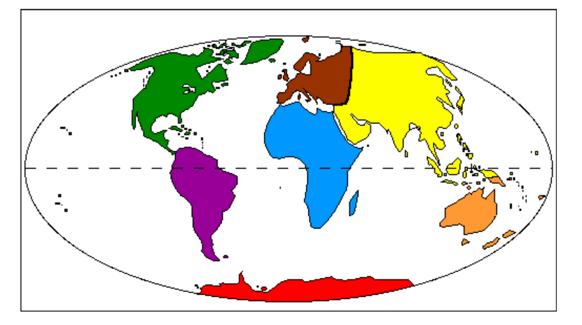
What is the name of the purple continent?

a)

North America

b)

South America

c)

Africa

d)

Europe

11.

What is the name of the green continent?

a)

South America

b)

North America

c)

Australia

d)

Europe

12.

What is the name of the brown continent?

a)

Antarctica

b)

Europe

c)

Africa

d)

South America

13.

What is the name of the yellow continent?

a)

Africa

b)

Europe

c)

Australia

d)

Asia

14.

What is the name of the blue continent?

a)

Asia

b)

Africa

c)

Antarctica

d)

Australia

15.

What is the name of the red continent?

a)

South America

b)

Australia

c)

Antarctica

d)

Asia

16.

What is the name of the orange continent?

a)

Australia

b)

Antarctica

c)

Africa

d)

North America

17.

What is the name of the imaginary line that runs from east to west, and separates the Northern and Southern Hemispheres?

a)

Equator

b)

Prime Meridian

c)

Longitude

d)

Latitude

18.

What is the name of the imaginary line on the globe that runs north to south, and separates the Eastern and Western Hemispheres?

a)

Equator

b)

Prime Meridian

c)

Latitude

d)

Longitude

19.

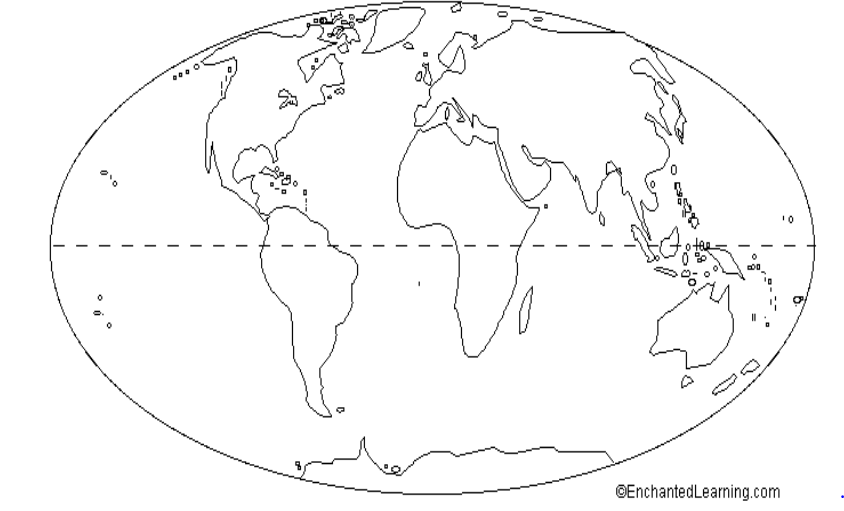
What is the name of the ocean labeled with a letter A?

a)

Indian Ocean

b)

Arctic Ocean

c)

Atlantic Ocean

d)

Pacific Ocean

20.

What is the name of the ocean labeled with a letter B?

a)

Arctic Ocean

b)

Southern Ocean

c)

Indian Ocean

d)

Atlantic Ocean

21.

What is the name of the ocean labeled with a letter C?

a)

Pacific Ocean

b)

Indian Ocean

c)

Arctic Ocean

d)

Atlantic Ocean

22.

What is the name of the ocean labeled with a letter D?

a)

Atlantic Ocean

b)

Indian Ocean

c)

Pacific Ocean

d)

Southern Ocean

23.

What is the name of the ocean labeled with a letter E?

a)

Indian Ocean

b)

Arctic Ocean

c)

Southern Ocean

d)

Pacific Ocean

24.

How many continents and oceans are there in the world?

a)

7 continents and 4 oceans

b)

8 continents and 4 oceans

c)

7 continents and 5 oceans

d)

8 contents and 5 oceans

25.
What is the map element that tells what symbols on the map mean?
a)
Key/Compass
b)
Key/Legend
c)
Legend/Scale
d)
Inset/Scale
26.
This map element tells the purpose of the map
a)
Title
b)
Scale
c)
Legend
d)
Key
27.
This element gives measurements  and shows distance between objects on the map
a)
Legend
b)
Key
c)
Title
d)
Scale
28.
Which map element is a smaller map that shows a "larger" area of land around the map.
a)
Title / Scale
b)
Key / Legend
c)
Inset Map
d)
Compass Rose
29.
Tells the subject of a map
a)
map key
b)
map scale
c)
map title
30.
The 0 degree latitude line that divides the Northern and Southern Hemispheres.
a)
Prime Meridian
b)
time zone
c)
equator
d)
International Dateline
31.
Lines of longitude are called this.
a)
meridian
b)
parallel
c)
equator
d)
longitude
32.
North, South, East, and West are referred to as the _________directions.
a)
raven
b)
bluejay
c)
cardinal
d)
robin
33.
Where would you find the symbol that indicates which city on the map is the capital city?
a)
map scale
b)
map legend
c)
map elevation
d)
map title
34.
Longitude and Latitude lines intersect to form the _________.
a)
graph paper
b)
global grid
c)
crisscross applesauce
d)
map scale
35.
NE, SE, NW, SW are these type of directions.
a)
cardinal
b)
intermediate
c)
main
d)
subterrain
36.
What type of map is this?
a)
Political
b)
Physical 
c)
Economic Activity
d)
Population
37.
What type of map is this?
a)
Population 
b)
Physical
c)
Political
d)
Climate 
38.
Using lines of latitude and longitude to find an exact location is...
a)
Absolute Location
b)
Relative Location
c)
Prime Meridian
d)
Place
39.
What map feature can help you determine the approximate distance between two locations?
a)
map scale
b)
key
c)
title
d)
distance calculator
40.
Lake Plains are _____ of the Appalachian Plateaus.
a)
Southwest
b)
Northwest
c)
Northeast
d)
Southeast
41.
Relative location is...
a)
how to get to a place
b)
finding the location of a place by describing its location from another place
c)
not a real thing
d)
exactly where something is located
42.
Lines of latitude are called this.
a)
tropic zone
b)
parallel
c)
polar zone
d)
meridian
43.
What is the measure of how far north or south a place is from the Equator called?
a)
Latitude
b)
Longitude
c)
Prime Meridian
44.
What is the measure of how far east or west a place is from the Prime Meridian called?
a)
Latitude
b)
Longitude
c)
Equator
45.
What  are these lines known as ?
a)
latitude
b)
relative location
c)
longitude
d)
absolute location
46.
What are these lines known as?
a)
latitude
b)
longitude
c)
relative location
d)
absolute location
47.
This type of map shows cities, states, and countries
a)
physical map
b)
political map
c)
historical map
48.
This type of map shows kinds of land and bodies of water
a)
Physical map
b)
political map
c)
historical map
49.
Latitude and Longitude are measured in ________.
a)
inches
b)
feet
c)
degrees
d)
grams
50.

The area at the top or bottom of a globe is called a ....

a)

point

b)

tip

c)

spot

d)

pole

51.

What is the study of the Earth?

a)

biology

b)

geography

c)

agriculture

d)

zoology

52.

What are the largest areas of land on Earth called?

a)

mountain

b)

plain

c)

continent

d)

country

53.

What are pictures on a map called?

a)

symbols

b)

photos

c)

pixels

d)

signs

54.

What is half of the Earth?

a)

piece

b)

half circle

c)

slice

d)

hemisphere

55.

What is the largest continent on Earth?

a)

Asia

b)

Africa

c)

Europe

d)

Australia

56.

What is the smallest continent?

a)

Europe

b)

South America

c)

North America

d)

Australia

57.

What does a map scale do?

a)

shows how big the map is

b)

shows how much a map weighs

c)

shows how tall a building is in real life

d)

shows how far away a place is in real life

58.

Which type of map shows the height of the land?

a)

physical

b)

political

c)

population

d)

elevation

59.

Which direction do lines of longitude run?

a)

North to South

b)

East to West

c)

Left to Right

d)

Around and Around

60.

Which line is just slightly north of the equator?

a)

Prime Meridian

b)

Tropic of Capricorn

c)

Tropic of Cancer

d)

North Pole

61.

What is another name for lines of longitude?

a)

Meridians

b)

Curves

c)

Circles

d)

Parallels

62.
What is the reason why latitude lines NEVER intersect? 
a)
They converge at the poles
b)
They are cool
c)
They are vertical lines 
d)
They are parallel
63.
Which letter would you find at 15oS, 60oW?
a)
A
b)
C
c)
L
d)
H
64.
Which ocean meets the coast of South Carolina?
a)
Pacific Ocean
b)
Atlantic Ocean
c)
Arctic Ocean
d)
Indian Ocean
65.
Which continent is touched by the Prime Meridian?
a)
North America
b)
Africa
c)
Australia
66.
What is the latitude of New Orleans?
a)
90*W
b)
30*N
c)
30*W
d)
90*E
67.

This photo best represents...

a)

H. E. I.

b)

Location

c)

Region

d)

Movement

68.

Explains how people, ideas & animals move from one place to another.

a)

Place

b)

Location

c)

Movement

d)

Human-Environment Interaction

69.

This photo best represents...

a)

Movement

b)

H. E. I.

c)

Region

d)

Location

70.

Describes the CHARACTERISTICS of a location. 

a)

Place

b)

H. E. I.

c)

Movement

d)

Region

71.

Provides a way of locating places. Absolute location is the exact point where a place is located, such as GPS (Global Positioning System) coordinates.

a)

Location

b)

Movement

c)

Place

d)

Region

72.

Explains how people affect the environment & how the environment affects people. 

a)

Movement

b)

Human-Environment Interaction

c)

Place

d)

Region

73.

This photo best represents...

a)

Movement

b)

Region

c)

Human Environment Interaction

74.

This photo best represents...

a)

Movement

b)

Location

c)

Region

75.

Which best describes Location?

a)

Where something is.

b)

The human and physical characteristics.

c)

Immigration

d)

Terrace farming

76.
What are the 5 Themes of Geography?
a)
Region, Human-Environment Interaction, Location, Climate, and Place
b)
Region, Human-Environment Interaction, Movement, Place, and Location
c)
Place, Movement, Location, Region, and Human-Alien Interactions
d)
Absolute Location, Relative Location, Climate, Vegetation, and Movement 
77.
Syrian refugees fleeing the Middle East into Europe and sanctuary countries around the world is an example of which of the 5 Themes of Geography?
a)
Place
b)
Location
c)
Movement
d)
Human-Environment Interaction
78.
Latitude lines run
a)
East/West
b)
North/South
79.
Longitude lines run _________.
a)
East/West
b)
North South
80.
Which of the following are examples of the human features of a place?
a)
traditions and population
b)
occupations and language
c)
education and cultures
d)
all of the above
81.

What theme does physical characteristics belong to? (Mountains, valleys, canyons, lakes, etc.)

a)

Place

b)

Location

c)

Region

d)

Movement

82.

What is the difference between place and location?

a)

Location is where something is, and place is the characteristics of it.

b)

There isn't a difference.

c)

Place is the location of something, and location is the characteristics of it.

d)

Location has to do with movement, and place has to do with interaction.

83.

Which is NOT one of the Five Themes of Geography

a)

Location

b)

Language

c)

Movement

d)

Region

84.

Place can be described as _____ something is, like a building or area.

a)

Who

b)

What

c)

Where

d)

Why

85.

Place can be described by both physical and _____ characteristics.

a)

Regional

b)

Human

c)

Logistical

d)

Weather

86.

A positive example of how the world impacts us is...

a)

A Tornado

b)

An Earthquake

c)

A Flood

d)

A gentle Spring rain

87.

A negative way we impact the world around is...

a)

pollution.

b)

mining all the resources.

c)

deforestation.

d)

All of the examples

88.

Sammaria takes a trip to Europe with her family. She notices that fashions in Europe are very different than they are in the United States so she decides to send Darertu a picture message showing and communicating to her some of the crazy outfits.

a)

Location

b)

Movement

c)

Human Environment Interaction

d)

Region

e)

Place

89.

Depend on, Adapt to, and Modify/Change the Environment

a)

Place

b)

Location

c)

Human Environement Interaction

d)

Region

e)

Movement

90.
_______________ Text identifying when the map was made and/or updated.
a)
Orientation
b)
Date
c)
Grid 
d)
Scale
91.
_____________ A north arrow is a symbol indicating the direction in which north lies; a compass rose is a symbol indicating the cardinal directions (N, S, E, W).
a)
Date
b)
Grid
c)
Scale
d)
Orientation
92.
_______________ Intersecting lines (called a “coordinate system”) drawn on a map to pinpoint location.
a)
Orientation
b)
Grid
c)
Scale
d)
Title
93.
____________ The relationship between distance on a map and actual distance on the earth,
a)
Title
b)
Scale
c)
Date
d)
Author
94.
________________ Text identifying where the map’s information comes
a)
Author
b)
Index
c)
Legend
d)
Source
95.
_________ A listing of the places on the map and where to find them using grid coordinates— either latitude-longitude (77°53’W, 38°02’N).
a)
Text
b)
Index 
c)
Author
d)
Scale
96.
___________ Text identifying the cartographer or organization responsible for making the map
a)
Author
b)
Date
c)
Text
d)
Scale
97.
Text explaining what the map is supposed to portray: what is happening, where, and when
a)
Text
b)
Date
c)
Title
d)
Source
98.

The acronym used to remember the most common map elements.

(a)  

99.

The final questions: A geographer who makes maps:

a)

Cartographer

b)

Distortion

c)

Projection

100.

The final questions: The change in shape, size, or location of a place when shown on a map.

a)

Map Projection

b)

Distortion