
 Worksheets
Biomes
Total questions: 101
Worksheet time: 1hrs 16mins
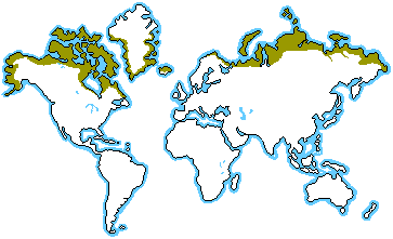


Which biome is the driest? It receives less than 10 inches of rain a year.
desert
grassland
deciduous forest
tropical rain forest

In which biome would you find giraffes and elephants?
desert
deciduous forest
savanna
tundra

In which biome would you find the best soil? It is called the “Breadbasket of the United States.
grassland
tundra
desert
tropical rain forest

Which biome is the largest land biome?
coniferous forest (taiga)
desert
tundra
tropical rain forest

Which biome has the greatest amount of biodiversity? (the most different kinds of organisms)
tundra
grassland
desert
tropical rain forest

In which biome would I find prairie dogs, is also known as “Tornado Alley”, and is flat with lots of grasses?
desert
grassland
tundra
tropical rain forest

Which biome has all four seasons and they are distinct? (you can tell which season it is)
tropical rain forest
desert
deciduous forest
grassland



TRUE or FALSE?
Each biome also has a characteristic set of organisms that are adapted to living there.
true
false


Rosa's neighborhood is only allowed to water their lawns on Tuesdays and Thursdays. What is the most likely explanation for why Rosa's neighborhood can only water their lawns two days a week?
Water is a renewable resource that needs to be conserved.
Water is a nonrenewable resource that needs to be conserved.
Water erodes the soil, and soil is a renewable resource that needs to be conserved.
Water corrodes the soil, and soil is a nonrenewable resource that needs to be conserved.
Atlanta often has smog warnings during the summer. The city cautions citizens against being outside too long when smog levels are high. How can the city of Atlanta reduce smog levels?
by increasing the use of fossil fuels
by decreasing the use of solar power
by decreasing the number of individual cars and increasing the number of buses
by increasing the number of individual cars and decreasing the number of buses
The citizens of a small fishing town are meeting to discuss a proposed new power plant. Paul, a local reporter, recorded the number of people who spoke at the meeting and what their top priorities were. Paul's data is shown.
Priorities:
Must be renewable- 10
No visible machines- 2
Must not hurt the fishing industry- 5
Must not pollute the air- 8
No dangerous waste products- 5
Paul plans to write a story about the town's preferences for the newspaper. Based on the data, what should the headline of Paul's story be?
Town wants coal, coal, and more coal!
Onward to the future, town to go nuclear!
Sunny days ahead, the people want solar!
Get caught in the current with hydropower!
How does population growth affect natural resources?
The more people on the planet, the less natural resources that are available for each person.
The less people on the planet, the less natural resources that are available for each person.
The more people on the planet, the more natural resources that are available for each person.

What is the theme of the Lorax
To protect the Earth's natural resources.
To waste the Earth's natural resources.
About how things change over time.
What were two ways the environment was harmed in the story of the Lorax
They cut down the trees without growing them back. And they were dumping waist into the ponds.
Nothing happened-the environment was fine.
The only thing that happened was water got a little dirty and a few trees were cut down.
What 3 environmental problems did the story of the Lorax illustrate? (Choose 3 answers)
Deforestation
Water Pollution
Air Pollution
Nuclear Pollution
Light Pollution
Which zone has the the coldest place on earth?
Tropical
Temperate
Polar
The climate zone that is between the Tropic of cancer and the Tropic of Capricorn
Tropical zone
Polar zone
Temperate Zone
In the temperate zone, there are ------ distinct seasons
four
five
three
six

What is climate?
the condition of the atmosphere at any given time and place
cloud cover and temperature
precipitation and humidity at a given time and place
weather conditions in an area over a long period of time
Climate is affected by many factors including:
latitude, elevation, and closeness to bodies of water
tides and currents
wind
snow and sleet
What is elevation?
the depth of the ocean
the height of the atmosphere
the depth of a lake
the height above sea level
What are the three main climate zones?
tropical, thermal, polar
tropical, temperate, polar
cold, super hot, blah
polar, tropical, humid
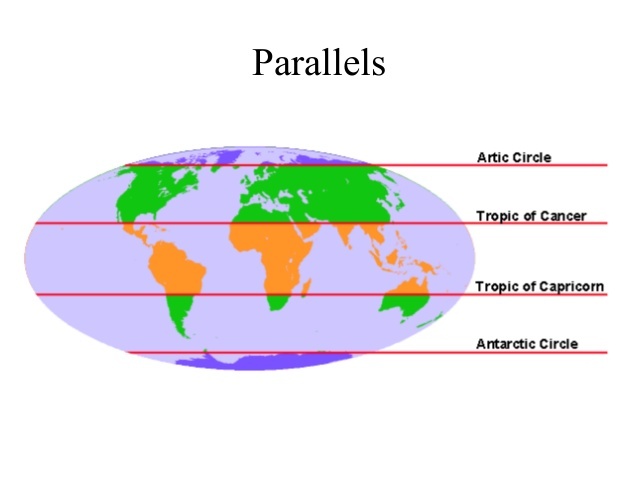
Which climate region is in green/in between the tropics and the poles
Hot
Polar
Temperate
None of the above
The movement of the tectonic plates is caused by
the rotation of the Earth.
convection currents in the Asthenosphere
the gravity of the iron-nickel core.
the Moho discontinuity.
In some areas of the world, like California and Japan, earthquakes are a common occurrence. How can this best be explained?
The strong ocean currents are undermining both areas causing earthquakes.
Both areas are located near the edge of the Pacific Ocean, the unstable sand causes earthquakes.
Both areas are subjected to strong ocean wind and waves that causes earthquakes.
Both areas are on the boundary of active plates, the motion of the plates causes earthquakes.
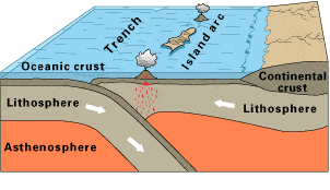
Observe this diagram of a plate boundary. One statement BEST describes what is happening. It is that
the oceanic crust is melting.
the denser ceanic crust is subducting under the less dense oceanic crust
volcanic islands are forming.
the tectonic plates are moving away from each other.
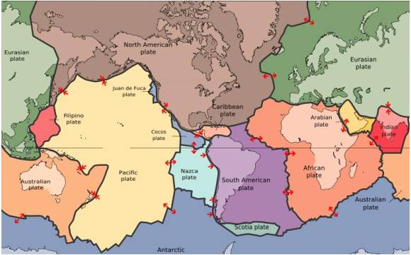
The map in the picture shows tectonic plate boundaries. This map would be useful in predicting the location of future
droughts
hurricanes
earthquakes
tornadoes
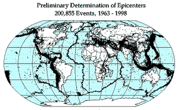
Earthquake epicenters (center of where the earthquakes started) were mapped for a 35 year period in the diagram above. The black dots indicate these epicenters. The black dots appear along what feature on Earth?
hot spots
plate boundaries
rift zones
sea floor spreading
The 2004 Indian Ocean tsunami was caused by a shift in two plates that pushed one section of the sea floor under another section of the sea floor by 5 meters. What type of boundary is this?
divergent
convergent
transform
metamorphic
What type of map shows boundaries and capitals/cities?
Political map
Absolute map
Physical map
Special Purpose Map
What type of map shows the topics, vegetation, and land use?
Political Map
GPS Map
Special Purpose Map
Physical Map
My house is 4 blocks from Spann Elementary. What type of location is being described?
GPS location
coordinates
Absolute location
Relative location
1. What elements of study do human and physical geography have in common?
They are trying to solve the problem of how to manage the global birth rate.
They are trying to solve the problem of how to manage the natural environment.
They are concerned with where things occur and why they occur where they do.
They both focus primarily on natural phenomena such as earthquakes and rivers.
Multiple "layers" of spatial information are stored in a computer system known as a(n):
GPS (Global Positioning System).
API.
remote sensing.
GIS (Geographic Information Systems).

A natural feature of the earth's surface shaped by processes that push the earth's crust up or wear the earth down
Biosphere
Landform
Body of Water
Atmosphere
A natural feature of the earth's surface shaped by processes that push the earth's crust up or wear the earth down
Biosphere
Landform
Body of Water
Atmosphere

Large area of flat or gently rolling land
plateau
valley
plain
mesa

large, mostly flat area that rises above the surrounding land
plain
canyon
ravine
plateau

An area that rises above surrounding land and has a rounded top; lower and less steep than a mountain
hill
basin
flood plain
valley

Landform that rises steeply at least 2,000 feet above surrounding land; usually wide at the bottom and rising to a narrow peak or ridge
hill
mountain
plateau
volcano

Low stretch of land between mountains or hills
valley
basin
flood plain
bay

Flows downhill, usually emptying into a larger body of water
lake
downpour
gulf
river

Long chain of mountains that lie close together
mountain pass
mountain top
mountain of food
mountain range

deep valley with steep sides and a flat bottom; often has a stream flowing through it
peninsula
canyon
cliff
ravine

landform that runs parallel to the coast
beach
butte
basin
bay

Land surrounded by water on all sides
island
isthmus
peninsula
strait

Area of land surrounded by water on three sides
glacier
isthmus
plain
peninsula

plain at the mouth (end) of a river, often triangular in shape
triangle
basin
flood plain
delta

group of islands
archipelago
beach
peninsula
chain

Layer of gases that surrounds the earth
atmosphere
hydrosphere
lithosphere
biosphere

the life-sustaining part of the earth
atmosphere
hydrosphere
lithosphere
biosphere

The solid part of the earth (includes crust, upper mantle, landforms)
atmosphere
hydrosphere
lithosphere
biosphere

Watery part of the earth's surface
atmosphere
hydrosphere
lithosphere
biosphere

A mound of sand deposited by wind
island
peninsula
dune
archipelago
What it's like in a particular place
Conditions
Connections
What it is like around a particular place that affects you
Conditions
Connections

Highest mountain in the world
Mt.Denali
Mt. St. Helens
Mt. Kilimanjaro
Mt. Everest
Which statement best explains why early civilizations were located in large river valleys/
Rivers contributed the resources needed for widespread agriculture to develop.
River valleys provided the natural obstacles needed to protect against conquest.
River valleys had the kind of temperate climate that humans are adapted to the best.
Rivers made it easier for people to travel the long distances needed to trade with others.
A _______ is where people build their homes.
Homes
Society
Settlements
Sea

What are homes of ice called?
Ice homes
Igloos
Eskimos
Homes in the snow
None of these
Transport is the means by which _________ can move.
People and goods
Animals and cotton
Laptops and sweets
Invention of the ___________ made transport easy.
Plane
Wheel
Steam engine
None of these

